

I know I said yesterday’s post would be my last for a while, but a quick follow-up is in order, by way of elaboration on my statement that “for now, hurricane trackers can (probably) take a deep breath for a little while” as we head into an expected quiet period. (It’s the calm before the storms; the season’s peak is on its way.) Why the follow-up? Because the Capital Weather Gang has a pretty awesome post about the reason for the forthcoming calm period: a giant cloud of dust from Africa has emerged over the Atlantic, and will almost certainly choke out any potential for tropical development in the immediate future. Here’s what it looks like from NASA’s Terra satellite:
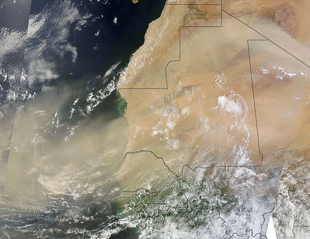
Cool! Think of it as a haboob of epic, oceanic proportions. :) Or not; I just love saying the word “haboob.” Almost as much as I love referencing Sharknado. (“Haboobnado”?)
Anyway, enough silliness. “Gang” member Jason Samenow explains what’s going on:
Africa sneezed, and the tropical Atlantic is choking.
An intense, sprawling dust storm exited the African west coast earlier this week, effectively squashing any tropical storm formation in adjacent Atlantic waters for days to come. …
Over the Atlantic ocean, the storm has formed a highly concentrated layer of atmospheric dust, known as the SAL (Saharan Air Layer). It is characterized by extremely dry air, which acts to suffocate the development of thunderstorms and the organization of tropical weather systems.
More #science in a moment, but first, how about an awesome GIF?
Here’s a nifty 5-day animation, courtesy of CIMSS:

The yellows, oranges, reds and pinks represent dry air and/or Sarahan dust.
Notice, at the beginning of the GIF, how you can see Tropical Storm Dorian on the center-left side of the image. The first frame is from when Dorian was dying, and then you can watch the storm “exit stage left” as he proceeds through his various undead, re-dead and zombiewave phases. As you watch, notice how, in those early frames, tiny scattered pixels of yellow and orange represent the “dry air” that doomed Dorian.
Then notice how, right around the time when ex-Dorian is disappearing off the map on the left-hand side, a massive clump of red and pink explodes off the African coast in the middle of the GIF. That, of course, is our dust cloud — and it makes the “dry air” that killed off Dorian look positively puny by comparison. No wonder these dust clouds suppress development! Yikes!
This dust cloud is expected to cover all the lands with a second darkness span the entire tropical ocean from the coast of Africa to Puerto Rico by the weekend, and then keep moving west from there:
So… why is dust bad for hurricanes, anyway? Dr. Jeff Masters brings the #science:
Saharan dust can affect hurricane activity in several ways:
1) Dust acts as a shield which keeps sunlight from reaching the surface. Thus, large amounts of dust can keep the sea surface temperatures up to 1°C cooler than average in the hurricane Main Development Region (MDR) from the coast of Africa to the Caribbean, providing hurricanes with less energy to form and grow. Ocean temperatures in the MDR are currently 0.7°F above average, and this anomaly should cool this week as the dust blocks sunlight.
2) The Saharan Air Layer (SAL) is a layer of dry, dusty Saharan air that rides up over the low-level moist air over the tropical Atlantic. At the boundary between the SAL and low-level moist air where the trade winds blow is the trade wind inversion–a region of the atmosphere where the temperature increases with height. Since atmospheric temperature normally decreases with height, this “inversion” acts to but the brakes on any thunderstorms that try to punch through it. … The dust in the SAL absorbs solar radiation, which heats the air in the trade wind inversion. This makes the inversion stronger, which inhibits the thunderstorms that power a hurricane.
Dr. Masters adds a third possible affect as well: when dust particles are the right size to serve as “condensation nuclei” capable of assisting in cloud formation, this can have uncertain impacts — potentially positive or negative, depending on the circumstances — which are still being studied. But the overarching theme certainly is that a massive dust cloud like this hurts hurricane formation.
Masters further explains that these oceanic dust clouds, which we tend to generically call “Saharan” (because #racism?), actually come from two different dust-storm-producing regions in west Africa: the southwestern Sahara Desert and the northwestern Sahel region. Sarahan dust “stays relatively constant from year to year,” but there is significant variability in the amount of Sahel dust. Research suggests that the most critical factor in this annual variability is “the level of drought experienced in the northwestern Sahel during the previous year.” Alas, 2012 was actually much wetter than usual in the northwestern Sahel — so, in the longer term, we should see “less dust than usual over the Atlantic this fall, increasing the odds of a busy 2013 hurricane season.”
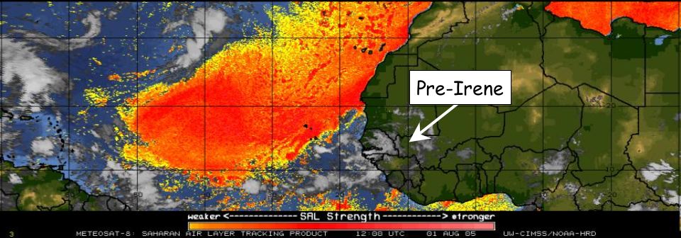
In other words, beware the fallacy that Michael Watkins warns of in a trio of tweets:
I find it fascinating that even experienced [meteorologists] look at current dry air in the Atlantic and project it to stay all season. #persistancebias … [Look at the] Saharan Air Layer outbreak image/analysis (pre-Irene) from August 1st, 2005 – these happen every year. … Full analysis of research experiment pre-Irene in 2005 – Atlantic systems develop between SAL’s.
So, even a mega-dusty SAL in early August doesn’t prevent, say, a Katrina in late August. Duly noted.
Still, in the immediate short term, this particular massive dust storm — which Dr. Masters says is pretty typical for the peak dust-storm months of June and July — “will sharply reduce the odds of tropical storm formation during the first week of August.” The dust largely explains why “none of the reliable computer models is predicting Atlantic tropical cyclone formation” in that time frame. (Read the whole thing.)
So, in conclusion, this blog should have nothing to write about for a little while. Also, per Jim Cantore, get ready for some gorgeous sunsets in the Caribbean and Florida.
Anyway, I’m out. Like I said last time, this will be my last Weather Nerd post until something else pops up that warrants attention, from the perspective of a possible U.S. threat. In the mean time, follow me on Twitter!


Join the conversation as a VIP Member