

This morning’s biggest “storm” might be the Chris Christie–Rand Paul civil liberties feud — and the most exciting “weather forecast” might be the announcement that Sharknado is coming to theaters next Friday at midnight — but there’s also still some noteworthy action in the tropical Atlantic, barely. Tropical Storm Dorian is still chugging west-northwest at 21 mph with estimated top winds of 50 mph. Yesterday I called Dorian a “survivor,” but today, it’s clear that it’ll take all the strength he has not to fall apart, as he tries hard to mend the pieces of his broken circulation’s heart. (Sorry.)
The storm is continuing to struggle mightily against dry air:
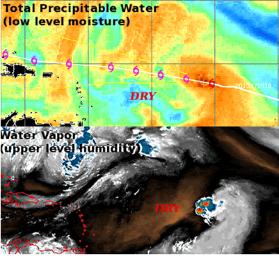
Image credit: CIMSS and NOAA, via the Capital Weather Gang. As CGW explains, warm colors on the top map indicate moisture, while cool colors indicate it’s too dry for a tropical cyclone (primarily in the lower atmosphere); brown colors on the bottom map represent dry air (primarily in the upper atmosphere).
The NHC explains:
VISIBLE SATELLITE IMAGES SHOW THAT THE CLOUD PATTERN OF DORIAN IS RATHER DISORGANIZED…WITH LITTLE OR NO EVIDENCE OF BANDING FEATURES. WATER VAPOR IMAGERY AND TOTAL PRECIPITABLE WATER DATA [i.e., the maps above] INDICATE THAT DORIAN WILL BE ENCOUNTERING DRY AIR OVER THE NEXT DAY OR SO AND THIS…ALONG WITH MODERATE WEST-SOUTHWESTERLY SHEAR…SHOULD CAUSE SOME WEAKENING OF THE TROPICAL CYCLONE. … AN ALTERNATIVE SCENARIO…WHICH IS CERTAINLY POSSIBLE…IS THAT DORIAN COULD DEGENERATE INTO A TROPICAL WAVE WITHIN THE NEXT COUPLE OF DAYS.
The Capital Weather Gang characterizes the situation thusly: “The increased vertical wind shear and persistent dry air have broken down tropical storm Dorian’s defenses.” Those “defenses” were initially quite strong — creating the impression of Dorian as a “survivor” — in part because, as Levi Cowan notes in an exceptionally informative video update on his “Tropical Tidbits” blog, “Dorian is very small, and small systems like this are good at fighting dry air.” But there’s a lot of dry air ahead of Dorian, cutting off its moisture supply. That’s pretty typical for this still early stage of the hurricane season, as Hurricane Track’s Mark Sudduth noted yesterday:
It's not unusual for there to be quite a bit of drier, more stable air this time period of the hurricane season. No shock Dorian struggling.
— Mark Sudduth (@hurricanetrack) July 26, 2013
Anyway, dry air “is encroaching on the storm through a significant depth of the atmosphere” — at both upper and lower levels, as the map shows — which is largely why Dorian’s “has lost a lot of organization in the past day,” Capital Weather Gang writes. “And it’s probably not going to escape this hostile environment for a few more days.”
There are other factors, also worth mentioning, which are contributing to Dorian’s struggles as well. One is wind shear. As Ed Piotrowski explains, “because Dorian is moving so quickly, it’s creating its own wind shear that’s pushing storms away from the center.” That’s somewhat reminiscent of the even-faster-moving Chantal, leading my jokey comment yesterday that Dorian might be turning into “Chantal 2: Cape Verde Boogaloo.” But Levi Cowan says that’s not quite right: “This is not a Chantal situation. When Chantal was trying to keep a closed cirulation, she had strong trade wind flow everywhere around here. Right now, Dorian has a very strong trade wind flow just to his north, but the winds to his south…are much slower in speed.” As a result, even despite Dorian’s fast pace, the shear is only moderate. The trouble, as Cowan also notes, is that while small storms like Dorian are good at fighting dry air, “they’re terrible at fighting wind shear.”
Another factor contributing to Dorian’s weakening over the last 18-24 hours is the simple fact that the storm has moved further west, away from the moist “monsoonal flow” that’s blowing from southwest to northeast over the waters closer to Africa. As Cowan explains, that flow “shuts off” west of roughly 40 degrees west longitude, and trade winds resume, “so Dorian is now completely isolated from Intertropical Convergence Zone, and he is on his own.” Previously, the monsoonal flow and ITCZ were lending Dorian a helping hand, atmospherically speaking. Now, “it will be up to him, and him alone, to maintain himself off of the ocean water beneath him.”
Cowan further explains that yet another issue hampering Dorian right now is the rise in nearby barometric pressures. “Dorian is becoming isolated in an area of sinking and stabilizing air around him,” Cowan says. He illustrates this with a helpful map, but rather than re-posting it, let me just embed Cowan’s video, which is seriously worth the 8+ minutes it takes to watch. It really explains, succinctly and scientifically but with minimal jargon, what’s going on:
So, what’s next for Dorian? The first question is whether it will even survive the next day or two. As the NHC said, degeneration to a tropical wave — an “open wave” without a “closed” counterclockwise circulation — is distinctly possible. A “decoupling episode” last night, disrupting the synchronicity between the storm’s upper and lower level circulations, coupled with the ongoing dry-air entrainment, wind shear, and the other factors mentioned above, make this a perilous moment for Dorian. Says Cowan: “If he opens up today…and loses the convection, it could be good night to Dorian, and he may actually dissipate here.”
Cowan thinks Dorian will maintain a closed circulation, in part because (contra Chantal) the aforementioned trade-wind pattern — strong winds north of the storm, weaker winds south of it — is creating “an area of natural vorticity in front of” the storm. But it’s a very difficult question to confidently forecast. Charles Fenwick‘s take:
The question for Dorian is whether its environs are absolutely inhospitable for tropical cyclones or merely unfavorable for strengthening. The storm is being pushed along at a brisk pace, but not as fast as Chantal. The shear is there, but not in a debilitating quantity. The air is dry and that’s a negative too. Maybe it adds up to enough that the Hurricane Hunters fly on Sunday and don’t find a circulation. But for now, I am slightly biased towards the Dorian persisting for the duration. Still a bit of time for everyone to wait and see.
I guess we’ll find out in the next couple of days whether this storm really is a “survivor.”
If Dorian does survive the short-term threats to its survival as a tropical cyclone, the next major question will be that occurs when it reaches the area around Puerto Rico, Hispaniola and the Bahamas. Cowan points out a peculiar fact: the atmospheric environment in 4-5 days near those islands looks like it will “not the most unfavorable situation in the world” — indeed, it will have some favorable features, counterbalancing some potentially unfavorable ones (watch the video above for more) — yet although “the environment doesn’t look particularly unfavorable in the southwestern Atlantic, the models are now all pessimistic” about Dorian’s potential for development in that area. You can see that clearly by comparing the GFS model forecast for Dorian’s approach to Hispaniola with the GFS forecast from 2 days ago for Dorian at roughly the same longitude:
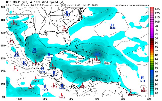
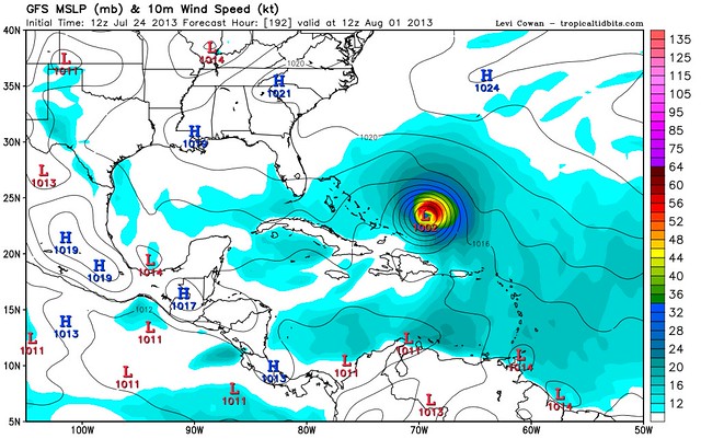
Cowan, for his part, thinks that something like the bottom forecast (from two days ago) is still possible, if Dorian’s survives intact as a closed circulation over the next few days. “Dorian could either become a hurricane, if he survives and strengthens like the GFS was showing a few days ago, or he could dissipate,” Cowan says. “It’s a little bit hard for me to believe that, if Dorian retains a closed circulation,” he will weaken as much as forecast. Part of the reason is that sea-surface temperatures will get progressively warmer as Dorian moves west, eventually as much as 1.5 to 2 degrees Celsius above what Dorian is traversing now. Thus, “if all else remains equal in his environment,” Dorian ought to strengthen. Cowan predicts: “If he retains a closed circulation, he should be able to be a little bit stronger [north of the Lesser Antilles] than what the GFS shows.”
He adds, though, that “the confidence, at least in my mind, for the intensity forecast [for] days 3-5 is lower than normal…because of all the balancing [of] negative and positive factors…and given Dorian’s small size. It’s always very hard to predict the intensity of tiny storms because they are very fragile, but they can also ramp up in a hurry due to warm water feedback. So this is going to be an interesting storm to track.” The storm could still be a “long-term threat” to become a hurricane, and eventually menace the U.S. East Coast sometime late next week, “but there is still a large, large degree of uncertainty.”
I haven’t said much yet about Dorian’s track yet. Here’s the official NHC forecast as of 11am EDT:
11am updated #Dorian track from the NHC. pic.twitter.com/UCjdaDxDtU
— Mike Hanson (@mikehanson28210) July 26, 2013
Ed Piotrowski explains:
Let’s assume Dorian survives. The track for the next 3-4 days is pretty straightforward. A huge ridge [of upper-level high pressure] to the north of the storm will steer it westward to a point near or north of Puerto Rico and Hispaniola. By early next week, it’s not as clear, since the long range models have been inconsistent with their tracks. For example, on Thursday morning, forecast tracks for Dorian ranged from a landfall near Houston, TX to curving out to sea near Bermuda. On Thursday night, many of the reliable forecast models shifted significantly farther south and are in much better agreement with no turn toward the southeast U.S. or Bermuda. Most of these tracks take Dorian over the Greater Antilles (Puerto Rico, Hispaniola and Cuba) and eventually into the Gulf of Mexico. The big difference? The trough [of upper-level low pressure] that could turn Dorian northward is weaker [than previously forecast], which allows the ridge of high pressure to build westward into Florida. This extension of the ridge protects the Carolinas by blocking a turn to the north. If this pans out, land interaction [with the Greater Antilles] could kill Dorian. While this is certainly encouraging, its not etched in stone. Let’s see if the models continue this trend over the coming days.
It’s worth adding that the possibility of Dorian going into the Gulf of Mexico is a good news/bad news thing. It’s bad news for folks on the Gulf coast, who thought they didn’t need to worry about this storm. But it’s good news in that it implies a weaker storm, as Capital Weather Gang explains: “[T]he longer it stays weak, the more westward it will move, since the low-level easterly trade winds will govern its motion as opposed to a stronger storm being steered by winds higher in the atmosphere.” Also, because the mountains of the Greater Antilles lie between Dorian and the Gulf of Mexico, a track that aims at the Gulf increases the likelihood of the storm’s tiny circulation being destroyed by interaction with mountainous land masses, as opposed a track through the Bahamas.
Anyway, as always, stay tuned. Check in here for periodic updates, and follow me on Twitter (@brendanloy) for more frequent tweets and RTs. Also check out Amy Sweezey’s “Wx Tweeps” Twitter list for frequent updates from various meteorologists and fellow weather nerds.


Join the conversation as a VIP Member