

Did I jinx Tropical Storm Dorian? No sooner did I declare the storm a “survivor” and an “overachiever” (and got Instalanched for it) than it began to struggle mightily. First, it started to look more ragged. Then, the computer models began to adjust their intensity expectations downwards, many calling for weakening or even outright dissipation:
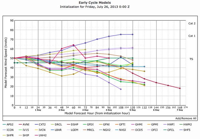
(Graphic via Tropical Atlantic, which is an awesome site, BTW.)
Then, the National Hurricane Center, in its 11pm EDT discussion, explained why the models were souring (again) on Dorian:
THE CONVECTIVE STRUCTURE OF DORIAN HAS NOT BEEN PARTICULARLY ORGANIZED THIS EVENING…AND RECENT MICROWAVE IMAGERY INDICATES THAT THE LOW-LEVEL CENTER LIES TO THE SOUTHWEST OF THE DEEP CONVECTION. … DORIAN HAS WEAKENED A BIT…AND THE INITIAL INTENSITY IS NOW [50 MPH, DOWN FROM 60 MPH]. …
DORIAN IS BEING DRIVEN QUICKLY WEST-NORTHWESTWARD BY A LOW- TO MID-LEVEL ANTICYCLONE OVER THE CENTRAL ATLANTIC…AND ITS ESTIMATED MOTION IS 285/17 KT. … DORIAN IS EMBEDDED IN AN ENVIRONMENT OF FAST EASTERLY LOW-LEVEL FLOW AND RELATIVELY LIGHT UPPER-LEVEL WINDS…WHICH APPEARS TO BE INDUCING SOME WESTERLY TO SOUTHWESTERLY SHEAR IN THE LAYER BELOW THE CIRRUS OUTFLOW. SINCE THE FORWARD SPEED OF THE CYCLONE IS NOT EXPECTED TO SLOW DOWN ANY TIME SOON…DORIAN COULD EXPERIENCE PERSISTENT SHEAR FOR THE NEXT FEW DAYS. ON TOP OF THAT…MID-LEVEL RELATIVE HUMIDITIES ARE EXPECTED TO DECREASE…AND THE DRY AIR COULD INHIBIT DEEP CONVECTION. NONE OF THE GUIDANCE SHOWS MUCH CHANGE IN INTENSITY DURING THE NEXT FEW DAYS…SO THE OFFICIAL FORECAST WILL KEEP THE WINDS FLATLINED AT 45 KT THROUGH DAY 3 WITH NOT MUCH STRENGTHENING THEREAFTER.
In other words, Dorian’s rapid forward speed may be starting to turn it into a scaled-back version of Chantal 2: Cape Verde Boogaloo. “A weaker Dorian’s low level center [is] outracing the thunderstorms…he will struggle to survive,” wrote Miami meteorologist John Morales.
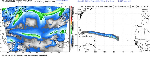
Meanwhile, that scourge of tropical cyclones — dry air — has finally cracked Dorian’s previously solid circulation, and begun to take its toll:
#Dorian’s #DOOM? RT @wxbrad: #Dorian is much weaker tonight & moving into a even more hostile environment. pic.twitter.com/DxebTLkuVc
— Brendan Loy (@brendanloy) July 26, 2013
Morales added that “days ago,” he had “mentioned 3 hurdles” to Dorians’ development: “(1) cool water, (2) dry air, (3) future shear. Whatever (1) didn’t do (2) is doing now.”
Meteorologist Michael Watkins of Hurricane Analytics summarized the sudden change this way:
8 hours ago it looked like #Dorian was thriving. Now, even at the diurnal max it's not holding up well due to the relative/mid level shear.
— Michael Watkins (@watkinstrack) July 26, 2013
Directional shear undercutting the outflow will disrupt much stronger systems than #Dorian esp. when pumping in dry, stable air.
— Michael Watkins (@watkinstrack) July 26, 2013
Watkins added that Dorian now looks a bit “wave-like” — in other words, its circulation may be losing some of its core organization.
North Carolina meteorologist Brad Panovich pointed out that both the GFDL and HWRF computer models — two of the most reliable American models, after the GFS — now “show Dorian dissipating as it gets into the Caribbean.”
A single run of those two models isn’t gospel, of course. (And the GFS, for its part, keeps Dorian intact long enough to slam Hispaniola — in which case the mountains would defeat it, probably.) But the overall trend in the models toward a more southerly track (i.e., closer to due west than WNW or northwest) is also indicative of weakening. If Dorian is a weak and disorganized system, it will be pushed more by lower-level steering currents, and will be unable to respond to shortwave troughs that could otherwise pull it more to the north. Thus, a more southerly track implicitly means a more disorganized storm.
Panovich comments: “The writing on the wall with this one.”
We’ll see. I’m not quite ready to give up on Dorian just yet. But a significant U.S. threat is certainly looking less likely tonight than it did this morning and afternoon.
Stay tuned. Follow me on Twitter (@brendanloy). Also check Amy Sweezey’s “Wx Tweeps” Twitter list for frequent updates from various meteorologists and assorted weather nerds.


Join the conversation as a VIP Member