

[NOTE: check the blog homepage and follow me on Twitter for the latest all weekend.]
* * * * *
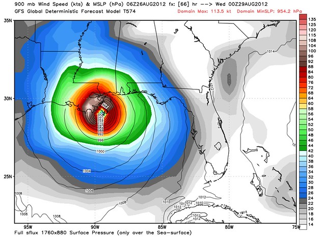
As Tropical Storm Isaac continues to churn–and struggle a bit–in the waters off Cuba, Hurricane Watches are up from southeastern Louisiana to the Big Bend of Florida, and the über-vulnerable city of New Orleans has moved inside the NHC’s cone of uncertainty. Three of the best American forecast models — the GFS, HWRF and GFDL — are in almost lockstep agreement this morning that Tropical Storm Isaac will track toward southeastern Louisiana over the next 60 or so hours. Here is what the GFS expects last Tuesday night — an intensifying, borderline Category 3-4 hurricane coming ashore on a near worst-case track for the Big Easy:
Despite all this, I get the sense that most people aren’t paying attention. Last night I noted that Drudge and NOLA.com still aren’t focusing on the New Orleans threat; well, they still aren’t. Moreover, Twitter searches for “New Orleans evacuation” and “Landrieu evacuation” (Mitch Landrieu is NOLA’s mayor) turn up almost literally no discussion. Not only have evacuations not been ordered yet, it seems nobody is even talking about the possibility. I keep seeing tweets from people who seem genuinely shocked when they learn New Orleans is under threat, like this is something nobody is discussing. Ugh.
Yet 48 hours from now, conditions could be starting to deteriorate in New Orleans. And pre-Katrina studies indicated it takes 48-72 hours to evacuate the city. WAKE UP, PEOPLE!! WAKE UP, MEDIA!! WAKE UP, GOVERNMENT!! This feels like 2005 all over again, in terms of the apathy and inattention at this stage. Isaac might not hit New Orleans — it might very well go elsewhere, I want to emphasize that — and it might very well not be as strong as feared (more on that below). But you don’t make preparations based on wishes and hopes. You make them based on realistic worst-case scenarios. The realistic worst-case scenario for New Orleans right now is really bad. People need to start paying attention to this!! If I lived in New Orleans, I’d already have packed my bags overnight and I’d be getting the Hell out of town this morning, as a precaution. The worst thing that can happen in an unnecessary evacuation is, you get a mini-vacation that proves to have been needless in retrospect because the storm doesn’t intensify much, or goes elsewhere. That’s a lot better than the worst thing that can happen if you stay (or wait too long to decide to leave), and the storm hits. New Orleans, remember, is largely a below-sea-level bowl. If you thought the levees breaking was bad, wait until you see what happens if a storm comes in on a sufficient worst-case track to overtop the levees. The long-studied worst-case scenarios for New Orleans are horrible.
Before I quote the NHC’s 5:00 AM advisory, I want to say a word about the uncertainty of this forecast, regarding the storm’s intensity in particular. Lest anyone believe I treat these computer model intensity projections as gospel, my personal feeling is that I’ll believe the modeled extreme strengthening when I see it actually begin to happen. Isaac has shown a tendency to underperform its intensity models thus far, and the waters in the Gulf aren’t as conducive to insanely rapid deepening as they were in 2005. I’d be pretty surprised if Isaac ever becomes a Cat. 4 or 5, and while I think Cat. 3 is very possible, I think a Cat. 1-2 type situation is also very possible. But again, planners, and folks in harm’s way, must assume the worst! I’m seeing some comments from folks dismissing the threat of a major hurricane as “nonsense,” or hype, given the storm’s current state. That’s ignorant. Don’t mistake your own suspicions and educated guesses for a scientifically unimpeachable forecast that people can rely upon when making life-or-death decisions. Isaac MAY VERY WELL NOT strengthen as much as forecast by the computer models, but that doesn’t mean we can dismiss and ignore those models. We must take them seriously, because what they’re predicting COULD occur. Rapid intensification can and does happen. Isaac wouldn’t be the first storm to look this disorganized, then be a major hurricane two days later. Will it happen? Again, we don’t know for sure, and I’ll fully believe it when I see it. But it’s not some crazy, hype-driven “nonsense” idea. To claim otherwise is not only ignorant but downright dangerous. That sort of false sense of security can literally kill people.
Anyway, from the NHC’s 5am EDT discussion… first, about intensity:
WHILE THE SATELLITE PRESENTATION OF ISAAC REMAINS SOMEWHAT UNIMPRESSIVE…WITH DEEP CONVECTION LIMITED TO A RATHER SMALL AREA NORTH AND EAST OF THE CENTER…AIRCRAFT DATA SUGGEST THAT THE CYCLONE HAS STRENGTHENED A LITTLE OVERNIGHT. PEAK 850-MB FLIGHT-LEVEL WINDS OF 69 KT IN THE NORTHEAST QUADRANT ADJUST TO AN INTENSITY OF 55 KT…WHICH IS THE VALUE FOR THIS ADVISORY. AIRCRAFT DATA INDICATE THAT THE MINIMUM PRESSURE HAS ALSO DROPPED A LITTLE…TO 995 MB. ISAAC STILL APPEARS TO BE BATTLING THE EFFECTS OF SOME LOW- TO MID-LEVEL DRY AIR IN THE WESTERN SIDE OF THE CIRCULATION…AS SEEN IN UPPER-AIR DATA FROM MIAMI AND KEY WEST. ASIDE FROM THIS…HOWEVER…CONDITIONS APPEAR FAVORABLE FOR STEADY INTENSIFICATION AS THE CYCLONE MOVE ACROSS THE FLORIDA STRAITS AND INTO THE EASTERN GULF OF MEXICO. WATERS ALONG THE FORECAST TRACK ARE VERY WARM…AND UPPER-LEVEL WINDS ARE FORECAST BY THE GLOBAL MODELS TO BECOME CONDUCIVE FOR STRENGTHENING.
NHC shows Isaac getting up to 105 mph — Category 2 — before landfall near Mobile, Alabama. But that track may shift further west at 11:00 AM or, more likely, 5:00 PM, depending in large part on whether the ECWMF (Euro) model, due out around 2:00 PM EDT, agrees with the GFS and other models. About the track:
ISAAC WILL MOVE GENERALLY WEST-NORTHWESTWARD OR NORTHWESTWARD AROUND THE WESTERN PERIPHERY OF THE ATLANTIC SUBTROPICAL RIDGE FOR THE NEXT 48 HOURS. BEYOND THAT TIME…THERE IS CONSIDERABLE SPREAD IN THE MODEL GUIDANCE. MOST OF THE MODELS…WITH THE EXCEPTION OF THE UKMET…NO LONGER SHOW ISAAC RECURVING AHEAD OF A SHORTWAVE TROUGH MOVING EASTWARD ACROSS THE EASTERN UNITED STATES. ONE CAMP OF GUIDANCE…INCLUDING THE GFS…HWRF…AND GFS ENSEMBLE MEAN SHOW A NORTHWESTWARD TRACK TOWARD THE CENTRAL GULF COAST AS THE SHORTWAVE BYPASSES ISAAC COMPLETELY. THE ECMWF AND GFDL SHOW HAVE MORE OF A WEAKNESS IN THE RIDGE AND SHOW ISAAC TURNING NORTHWARD TOWARD THE EASTERN GULF COAST. THE NEW NHC FORECAST IS FASTER THAN THE PREVIOUS ONE THROUGH MUCH OF THE PERIOD…BUT IS ALONG THE PREVIOUS TRACK THROUGH 36 HOURS. AFTER THAT TIME…A SIGNIFICANT WESTWARD ADJUSTMENT WAS MADE…AND THE NEW NHC TRACK IS CLOSE TO THE TVCA MULTI-MODEL CONSENSUS AND THE ECMWF…SHOWING A NORTH-NORTHWESTWARD AND NORTHWARD TURN AT DAYS 3 THROUGH 5. GIVEN THE LARGE SPREAD IN THE GUIDANCE…CONFIDENCE IN THE LONG-RANGE TRACK FORECAST IS QUITE LOW…AND IT IS TOO EARLY TO DETERMINE EXACTLY WHERE AND WHEN ISAAC WILL MAKE LANDFALL ALONG THE GULF COAST. FURTHER ADJUSTMENTS TO THE TRACK MAY BE NECESSARY LATER TODAY.
THROUGHOUT THE PERIOD…IT IS IMPORTANT NOT TO FOCUS ON THE EXACT FORECAST TRACK SINCE SIGNIFICANT HAZARDS EXTEND WELL AWAY FROM THE CENTER.
As I mentioned earlier, the GFDL has left the “Euro camp” and joins the “GFS camp.” (Mercifully, the GFDL shows a lot less strengthening the GFS or the HWRF.) If the Euro moves west too this afternoon, we’ll have a consensus forecast, and the confidence should increase in the 5pm discussion. Stay tuned.
For a schedule of forecasting-related events and links to watch today, see my previous post.
And again, check the blog homepage and follow me on Twitter for the latest.


Join the conversation as a VIP Member