

[Caveat: I just woke up, and have watched very little storm coverage in the media as of yet. This post is based entirely on tidal data, not damage reports.]
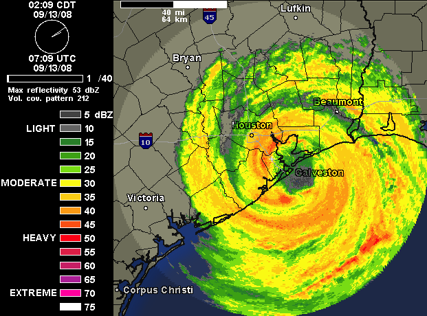
6:45 AM EDT: Hurricane Ike made landfall in Galveston at 3:10 AM EDT. Actually the center of the eye — which looked as impressive on radar at the moment of landfall as it ever has — passed over the narrow passageway between Galveston Island and the Bolivar Peninsula, not over the island’s West End as previously anticipated, thanks to some last-minute northward wobbles.
The Houston Chronicle‘s Eric Berger writes that, based on the landfall location, “the National Weather Service estimates that storm surge along the island will range from 14 feet on the island’s west end to 17 feet on the east end.” But as my tidal gauge data page shows, the surge appears to have peaked at between 9 and 10 feet at Galveston Pleasure Pier and Galveston Pier 21, both on the island’s east end, and the water level has been falling since shortly before the time of actual landfall.
Further up the coast, where computer models projected a surge of 20+ feet, the tidal gauge information is harder to definitively interpret. When Rollover Pass stopped reporting new data at around 2:00 AM EDT, the surge was at 11 feet and had not begun falling, although it looked like it was possibly beginning to plateau. The Sabine Pass North station is still reporting, and the surge there appears to have plateaued at around 10 feet, though the data looks somewhat sketchy. There are no NOAA tidal stations on the stretch of coastline in between Rollover Pass and Sabine Pass — where the heaviest surge would have been expected.
Nevertheless, it appears clear that Ike’s storm surge did not reach the catastrophic levels that experts had predicted. Before going to bed last night, I wrote, “I guess we can hope the surge projections are somehow flawed, due to the computer models failing to capture something about Ike’s bizarre structure, or whatever. In other words, we can hope against hope that things won’t be as bad as we presently fear. I don’t know that there’s any valid reason to hope that, but I’ll hope it anyway.” Initial indications are that these hopes were vindicated.
Alan Sullivan, who was a lone voice in the wilderness yesterday arguing against the computer models’ predictions of a supermassive surge, wrote yesterday morning, “Extreme surge scenarios are being propounded for this storm. I suspect we will learn that they are excessive. Ike is too broad and weak to follow models based on the tight core structure of a normal hurricane.” It seems he was right. Sullivan wrote at 3:30 AM this morning:
After viewing a lot of gauges, I can say the overall character of the surge fits my expectation so far. It is broader, but not as steeply pitched as models indicated. I do not think some of the extreme hypothetical values will be reached. But the surge is plenty bad nevertheless, and waves will exacerbate its damage, even on inland waters.
Sullivan is right: the light of day will undoubtedly reveal plenty of damage. I am certainly not intending to sound the “all clear.” Indeed, even as to Galveston itself, the Houston Chronicle reports at 5:31 AM EDT that “the east and west ends of Galveston Island are under water, and water [presumably from wave crests] is pouring over the seawall. Power and utilities are out. There are multiple fires; rain is helping extinguishing some.” Ike has delivered a heavy blow to the island, and its surge and waves will cut a wide and severe path of destruction in the bay and up the coast. How severe remains to be seen.
But, assuming the tidal gauges are reporting accurate data, it is clear that Ike’s storm surge was far less than feared, and for that, we should all be grateful.
P.S. Explanations of the discrepancy between the models and the reality will come later. It is premature to cry “hype,” and irresponsible to pretend that the threat was never real. That the storm surge apparently wasn’t as bad as the best scientific data, interpreted by the leading experts on the planet, had projected it would be, is cause for gratitude, not recrimination. Hindsight is 20/20, as always. The fear of a 20+ foot surge was genuine and, based on the available data, justified. Sullivan’s hunch that the surge would be lower than projected has evidently been vindicated, but that does not mean the dire warnings were uncalled for. Scientists must trust their data, and the data called for a Category 4 strength surge. Undoubtedly, Ike will lead to refinements in the models, and next time the data will be better. But as for this storm, the models’ inaccuracy is only certain in hindsight.
Moreover, to the extent Galveston & environs “dodged a bullet” with Ike (which remains to be seen; as I said, the damage will doubtless be plenty bad), this storm should be seen as a wake-up call, not a license to be cavalier with future storms. As even the hype-averse, Ike-deflating Sullivan writes: “One day there will be a category four storm arriving in this area at speed on a perpendicular course, and Houston will be devastated.” The threat to this metro area is real, regardless of whether Ike did less damage than feared. (Which, again, remains to be seen.) And the people in low-lying areas who refused to follow mandatory evacuation orders are still fools, even if they survived. (That, too, remains to be seen.) Next time they might not.
UPDATE: In comments, Jacflash writes, “Brendan, as you surely remember, at this moment with Katrina we thought NO had dodged a bullet, too. Let’s give it a few hours before we go too far down this line of thinking. Surges and tides are notoriously funny things.” He’s right, of course — that’s why I tried to emphasize that it remains to be seen what the damage will look like. It may look pretty terrible. We don’t know yet. But this post is about the tidal gauges. Those gauges say what they say, and I cannot imagine that a 20-foot surge will now suddenly materialize, with the storm moving inland and away from the coast.
UPDATE 2: Here’s Sullivan’s take. His title is “Overhyped After All,” which I object to as a matter of principle: it was either overhyped or it wasn’t, based on information available at the time; a storm cannot become “overhyped” in retrospect (“after all”). That’s 20/20 hindsight talking. Moreover, although Sullivan has license to crow a bit because of his correct prediction yesterday morning that the surge would be less than projected, he himself admitted this was only a “suspicion,” and last night he sounded about as alarmed as everybody else (recall “the most expensive hurricane in history”).
But I don’t mean to bash Sullivan. ;) He did a fine job blogging this storm, and was fundamentally right in his two core against-the-grain predictions: that Ike’s unusual structure meant it wouldn’t strengthen significantly, and that the storm surge would be lower than expected. Anyway, his latest post is worth reading. Money quote: “[Maximum storm surge] heights were only three to five feet above the levels everyone found so scary when the cameras were rolling yesterday. The early rise of the sea was not a harbinger of an excessive climax, but merely a measure of the storm’s breadth.”
UPDATE 3: Sullivan responds:
When it appeared for a few hours that landfall would be 20-30 miles SW of where it actually was — and I was fully persuaded of that — I was alarmed about Houston. This was the one place where I thought it was possible that model heights might be better justified. If the course of the eye had held NW for longer, onshore wind would have kept piling surge into the mouth of the bay, while flooding rains fell inland.
But as soon as it became apparent the eye was coming right over Galveston, that concern was alleviated.
As for the larger picture, my hive versus pimple analogy was plain common sense. I have learned in my sixty years that when somebody’s model defies common sense, it is usually best to ignore the model.


Join the conversation as a VIP Member