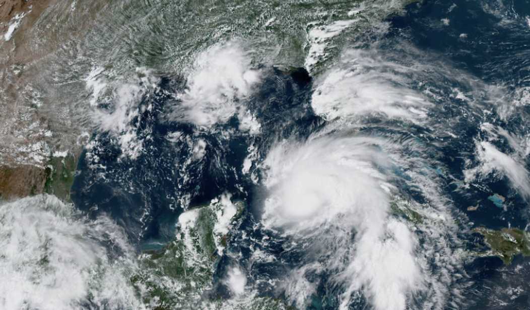
Early Monday morning, Tropical Storm Ian strengthened into a hurricane, according to the National Hurricane Center (NHC), and it now poses an increased risk to Florida and the eastern Gulf of Mexico.
The storm — expected to strengthen rapidly over the warm waters of the Gulf of Mexico — seems to have its eyes on Florida, though spaghetti models continue to shift the storm slightly east and west. As it closed in on the Gulf Monday morning, meteorologists indicated that the uncertainty regarding the storm’s track and strength is “higher than usual.”
Here are the 5 am Monday Key Messages for Hurricane #Ian. Latest information at https://t.co/tW4KeGdBFb pic.twitter.com/536aVhLwl5
— National Hurricane Center (@NHC_Atlantic) September 26, 2022
“Considerable flooding impacts are possible mid-to-late week in central Florida given already saturated antecedent conditions, and flash and urban flooding is possible with rainfall across the Florida Keys and the Florida peninsula through mid-week,” the NHC warned.
Regardless of location, all Floridians were asked to prepare for the worst, as large portions of the state will likely experience intense thunderstorm activity, possible tornadoes, and heavy flooding as Hurricane Ian makes its way to the U.S. mainland. The growing storm is expected to reach “major” hurricane status by Monday night. A major hurricane is a category 3 or higher on the Saffir-Simpson Hurricane Wind Scale.
As is typical under the threat of a hurricane, Floridians packed hardware stores and supermarkets over the weekend, buying up supplies just in case, even with the storm track’s uncertainty.
“Too soon to say if it’s going to be a southeast Florida problem or a central Florida problem or just the entire state,” said John Cangialosi, a senior hurricane specialist at the Miami-based NHC. “So at this point really the right message for those living in Florida is that you have to watch forecasts and get ready and prepare yourself for potential impact from this tropical system.”
CNN added:
After passing Cuba, Ian will track through the eastern Gulf of Mexico, bringing impacts to Florida as early as Tuesday.
Heavy rain, hurricane-force winds, and storm surge are expected across the Keys and the West Coast of Florida this week. The Florida Keys are forecast to see 4 to 6 inches of rain, west-central Florida is forecast to see 8 to 10 inches of rain with isolated totals up to 15 inches possible, and the remainder of the Florida Peninsula is forecast to see 3 to 8 inches.
Anticipating the storm’s effects later this week, a hurricane watch has been issued along the west coast of Florida from north of Englewood to the Anclote River, including Tampa Bay.
Gov. Ron DeSantis (R-Fla.) provided an update on Sunday regarding preparations the state is taking in anticipation of a high-level impact. The governor noted that the storm’s tracks are still uncertain but added that Floridians across the state should take measures to prepare for the worst.
“This storm has the potential to strengthen into a major hurricane and we encourage all Floridians to make their preparations,” DeSantis said in a statement, according to the AP. “We are coordinating with all state and local government partners to track potential impacts of this storm.”
Governor DeSantis Delivers Update on Tropical Storm Ian https://t.co/q4IRQRRh2N
— Ron DeSantis (@GovRonDeSantis) September 25, 2022
The Florida governor declared a state of emergency initially for a handful of counties, but given the shift in its predicted track, DeSantis expanded the state of emergency to cover the entire state. President Joe Biden has also declared a state of emergency for Florida at the federal level, which allows federal resources, such as those provided by FEMA, to get to affected areas as the storm makes its way inland. Biden also reportedly canceled a Tuesday trip to Florida because of the hurricane.
Additionally, Gov. DeSantis activated the Florida National Guard on Sunday. If Ian makes landfall in Florida as a major hurricane, which could happen as soon as early Wednesday morning, it will mark DeSantis’ first test of responding to a major hurricane impact during his first term as governor.


Join the conversation as a VIP Member