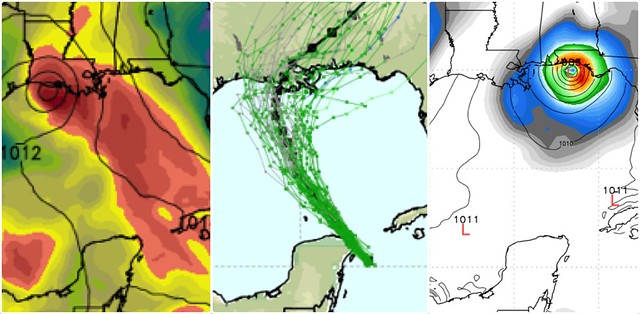
Tropical Storm Karen has formed in the Gulf of Mexico, and is expected to hit somewhere along the northern Gulf coast this weekend. Hurricane Watches are up from Louisiana to Florida.
The computer models are split on Karen’s likely landfall location, as you can see above. Shown are the Canadian model (left), the European model (center) and the American GFS model (right), via @RyanMaue. Here’s the official forecast from the not-shut-down-because-it’s-essential National Hurricane Center. But the bottom line is, forecasters aren’t sure yet where this thing is headed. One key point: the further east Karen goes, the stronger she’s likely to be. Conversely, further west = weaker.
The models agree, however, that Karen won’t get stronger than a Category 1 hurricane, and many models doubt she’ll ever graduate from tropical storm status. So this isn’t looking like a HELLSTORM OF DEATH worth hyping (not that that’ll stop Drudge & the cable newsies). But it certainly bears watching, and should be taken seriously by folks in the potentially affected areas. The storm is only ~2 days away, so the time to begin prudent preparations is now.
In order to avoid the massive time sink and brain damage of arguing with People Who Are Wrong On The Internet about the government shutdown and debt ceiling debate, and for other personal reasons, I’ve been on my own personal “shutdown” — an indefinite Twitter “hiatus” — this week, posting only the occasional Instagram and Tumblr link (totaling 2.5 tweets per day, vs. my normal pace of 100+ tweets per day), and avoiding Twitter interactions altogether. However, because of Karen, I will temporarily return to Twitter later tonight, and remain through the weekend before resuming my “hiatus.” You can follow me @brendanloy. I will also post a more complete update on Karen here on the blog later tonight.
In the mean time, here’s a reading list of weather-bloggers and tweeters who you should consider checking out.


Join the conversation as a VIP Member