10:43 AM EDT: A local National Weather Service official confirms what I reported earlier, based on the tidal gauges: Galveston experienced a “less severe storm surge” than anticipated, “only” 9 to 12 feet. And Eric Berger quotes UT engineer Gordon Wells as saying:
Damage from inundation caused by storm surge will be widespread across the region, but should not reach the catastrophic level that would have occurred, if several model predictions materialized. Heavy rains continue across the Houston metropolitan region, and bayou flooding may replace the storm surge threat, but if Ike exits the region on schedule, Southeast Texas will have escaped the worst.
Nevertheless, according to commenter Trent Telenko, local TV reports state that “most of Galveston Island is underwater, in some places 10-15 feet” — though Wells says the surge levels should translate to only “6-7 feet of water in the bayside area of the city, including UTMB and The Strand.” Whatever the exact amount, Houston Chronicle‘s Lindsay Wise confirms significant flooding:
The view from the 12th floor of the San Luis Hotel on the Galveston Seawall at 7:30 a.m. [CDT] was ominous. To the west, literally, was a lake.
Roofs were visible, and the the tops of trees. It looked like the Gulf had come on in.
Behind the hotel, to the northwest, most of the streets and parking lots were clear, and a car even drove by. But only the nearby area behind the wall could be seen; the continued rain and overcast cut visibility to less than a mile.
Seawall Boulevard was covered with broken glass and other debris, but was not under water, although tall waves continued to crash along it.
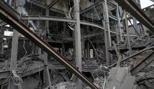
Meanwhile, although the surge was less severe than expected, it sounds like wind damage in Houston may have been worse than expected. The same NWS official mentioned earlier also said that “[a]s the hurricane approached the island, the winds were not as dramatic as earlier predicted… [but as] the eye of the storm moved further inland, the winds became more intense.” This is likely because of the circulation “tightening” due to interaction with land. And, as you can see in this archived radar loop, the western portion of the storm’s intense, tightening eyewall went right over downtown Houston.
Telenko has been watching local TV stations, and posting damage reports in comments. Among them:
There are trees down everywhere. More than 90% of Centerpoint Energy’s 2 million Houston area customers are without power. They are saying it will be weeks before all power is restored. . . . .
Channel 11 Houston just showed the east side of the JP Morgan tower — a 75 story sky scraper — and every window on the east side of the building has been blown out by wind.
Harris County also just briefed that only under ground power lines in Down Town Houston and the Texas Medical center survived the storm. All above ground electrical power lines are heavily damaged and inoperative in the Houston Area. . . .
Channel 11 Houston reports several square blocks of down town Houston are impassable to vehicles due to broken glass and other debris accumulated by winds between sky scrapers.
Alan Sullivan writes, “If Houston sustained this much damage in a cat 2 direct hit, imagine cat 4. It sounds as though local infrastructure needs review and upgrade. Maybe the city without zoning also lacks a building code, or fails to enforce the one it has.”
P.S. About that “bayou flooding” Wells mentioned, Berger has more detail:
White Oak Bayou: At 6 a.m. this morning White Oak Bayou had overtopped its banks. The bayou’s stage at Heights Boulevard was 37.6 feet, well above the flood stage of 32 feet. Forecasters say the bayou is expected to rise to 38 or 39 feet. That’s the level at which major lowland flooding occurs.
Buffalo Bayou: At 6 a.m. the stage was 23.1 feet, below the flood stage of 28 feet. Forecasters said the bayou should rise to near 29.5 feet this morning, a level which should produce moderate lowland flooding.
Greens Bayou: The bayou’s stage near U.S. 59 was at 52.1 feet on Saturday morning, below the flood stage of 55 feet. But the bayou was forecast to rise to near 56.2 feet this afternoon, which should produce some moderate lowland flooding.
UPDATE, 11:11 AM: The National Hurricane Center’s 11:00 AM EDT advisory is out. The discussion says:
ALTHOUGH IKE IS SPINNING DOWN AS A HURRICANE IN TERMS OF MAXIMUM WINDS…UNFORTUNATELY…ATMOSPHERIC CONDITIONS WILL GRADUALLY BECOME MORE FAVORABLE FOR TORNADOES TO DEVELOP ACROSS MUCH OF EASTERN TEXAS…WESTERN LOUISIANA…AND ARKANSAS THROUGH TONIGHT. LOCALLY HEAVY RAINFALL WILL ALSO BE A THREAT…AS WILL CONTINUED HIGHER THAN NORMAL TIDE LEVELS ALONG MUCH OF THE WESTERN LOUISIANA AND UPPER TEXAS COASTAL AREAS THROUGH AT LEAST THIS AFTERNOON.


Join the conversation as a VIP Member