

UPDATE: While it remains true that Felix “could have been worse” than it was, the damage to Puerto Cabezas was in fact worse than I initially believed. Dr. Jeff Masters writes: “Nearly every structure in Puerto Cabezas sustained at least roof damage, and many buildings were destroyed. Along the Moskito Coast of northeast Nicaragua, flooding and mudslides were reported, destroying many homes and blocking highways. The Government of Nicaragua declared the northern Caribbean coast a disaster area. At least 39 people have been reported dead–38 of them in Nicaragua, and one in Honduras (in a motor vehicle accident caused by heavy rain and landslides). However, dozens are missing (mostly at sea), and communications are difficult to impossible in many areas. At least 40,000 people have been affected and 9,000 houses destroyed, most of them in…Puerto Cabezas.” The good news is, the rain wasn’t as heavy as feared, so flooding and mudslides have not been widespread.
9:30 PM EDT
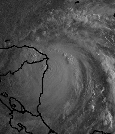
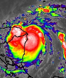
Hurricane Felix roared ashore in Nicaragua this morning, an unprecedented second Category Five hurricane in two weeks to hit Central America. Here is another pair of images of Felix making landfall at 7:45 AM EDT — at left, the visible satellite view as the sun rose; at right, the enhanced infrared shot:
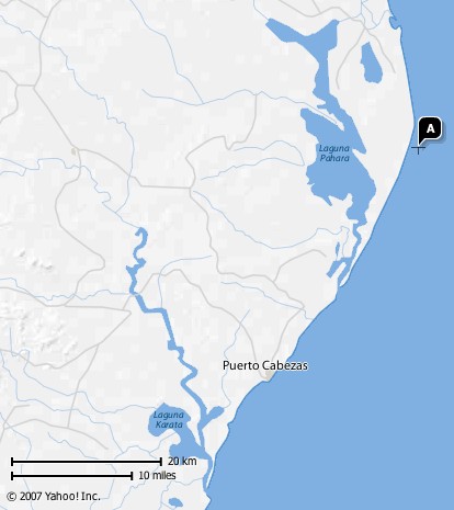
The center of Felix’s eye crossed land roughly 20 miles north-northeast of Puerto Cabezas, a city of 51,000 and the capital of Nicaragua’s Regi√≥n Aut√≥noma del Atl√°ntico Norte (RAAN). In the map below (courtesy of Yahoo), the “A” is the center of Felix, as pinpointed by the National Hurricane Center at 8:00 AM:
Incomplete and conflicting information abounds — call it “the fog of Felix” — but some reports indicate that at least two people died in the city. Red Cross official Claudio Vanegas said during the storm, “The winds are horrible. They send roofs flying through the air, so we aren’t going outside because it is too dangerous.”
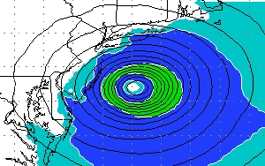
But while Puerto Cabezas clearly suffered some damage, the truly “horrible” winds — 160 mph sustained, with higher gusts (possibly much higher, since the storm was strengthening as it came ashore) — and the worst of the 18-foot storm surge were confined to the sparsely populated marshland regions along the Mosquito Coast north of the city. The southern side of Felix’s circulation, which hit the capital, was the smallest and weakest side, as this NOAA graphic demonstrates:
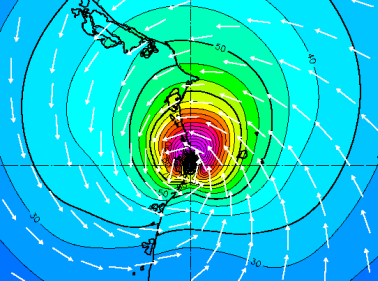
The three thick black lines represent, from outside to in, the boundary of tropical-storm force winds; of gale-force winds; and of hurricane-force winds. As you can see, Puerto Cabezas appears to have been just outside the hurricane-force wind radius.
Now, as of 8:00 PM, Felix has been downgraded to tropical-storm status, with 60 mph winds, and rapid weakening is expected as it continues to move inland over increasingly mountainous terrain. The main concern now is rain. According to Dr. Jeff Masters:
Felix’s rains will cause serious flooding and dangerous mudslides in Central America all along its path. But, it could have been much worse. … So far, satellite loops are showing that Felix has not yet tapped into the Pacific Ocean as a source of moisture. Both Hurricane Fifi of 1974 and Hurricane Mitch of 1998 were large and slow moving enough that they were able to draw in large quantities of warm, moist air from the Pacific over the mountains of Honduras. Felix just has Atlantic Ocean moisture to feed its rains, and this should prevent the storm from causing the kind of flooding catastrophe Fifi and Mitch did. With the eye of Felix over land and the storm weakening, I don’t believe the storm will be able to match the 20+ inch rainfall totals of those storms. Even so, the 5-10 inches of rain predicted by NHC will cause severe flooding and dangerous landslides throughout Honduras and portions of Nicaragua, Guatemala, Belize, El Salvador, and Mexico.
Meanwhile, as if one hurricane smacking Latin America wasn’t enough, a second made landfall just 9 hours later, over on the Pacific side. Hurricane Henriette hit the southern tip of Baja California, near San Jose Del Cabo, at around 5:00 PM EDT. Although Felix has grabbed all the headlines, thanks to its sexy and scary Category 5 status, Henriette is deadlier thus far, with seven deaths to Felix’s four. Of course, both death tolls could well rise.
Now, all eyes turn to the waters off the Southeastern U.S., where Tropical Depression Seven — and perhaps Tropical Storm Gabrielle — could soon form. The computer models disagree about whether “Invest 99L” will develop, and if so, where it will go. One of the more intriguing model forecasts, from the HRWF, brings “Gabrielle” into Long island and New England as a weak hurricane this Saturday:
Other models, as Dr. Masters points out, take the storm to North Carolina, South Carolina and Florida. The “spaghetti” computer model chart looks more like a squashed spider in this case:
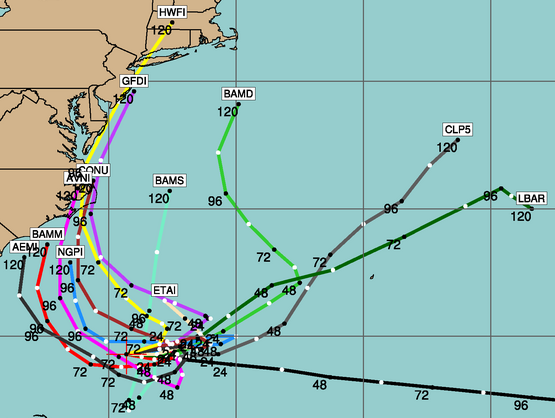
It’s way too early to draw any conclusions or make serious forecasts about 99L; indeed, it may never form into a depression. But stay tuned. It certainly bears watching — which probably explains why Dr. Masters, Eric Berger, Brian Neudorff and Alan Sullivan are all watching it.
Last but not least, I’ll conclude with one final note on Felix. Randy Bynon has posted some amazing pictures from his flight into Hurricane Felix yesterday morning on a Hurricane Hunter aircraft. If you’ve never seen what the moon rising over a Category Five hurricane’s eyewall looks like — I certainly never had — it’s well worth checking out.
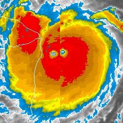
Satellite image of Felix at 4:45 AM PDT making landfall as a Category 5: It’s he first time in recorded history that two Atlantic-basin hurricanes have made landfall at Category 5 strength in the same season. And within two weeks of one another, no less. [Source]

4:56 am PDT:
Felix makes landfall in Nicaragua. (CNN)
3:49 am PDT:
Mere moments after I completed the post below, the National Hurricane Center issued the following statement, at 6:40 AM Eastern time: “SATELLITE IMAGERY INDICATES THAT HURRICANE FELIX HAS CONTINUED TO STRENGTHEN…AND HAS BECOME A POTENTIALLY CATASTROPHIC CATEGORY FIVE HURRICANE WITH MAXIMUM SUSTAINED WINDS OF 160 MPH…260 KM/HR…JUST OFF THE COAST OF NORTHEASTERN NICARAGUA.”
3:42 am PDT:
Hurricane Felix has re-strengthened overnight to the very threshold of Category Five status, with 155 mph winds gusting to at least 169 mph. The eye of the monster storm will come ashore in northern Nicaragua around 8:00 AM EDT — and it “could reach Category Five strength just as it crosses the coast,” according to the headline on the National Hurricane Center’s 5:00 AM advisory.
As I pointed out when Hurricane Dean was approaching Jamaica, “major hurricanes are worse when they are strengthening than when they’re stable or weakening; the greater instability of the intensification cycle leads to higher wind gusts and such. In other words, the only thing worse than a Category 5 hurricane making landfall is a strengthening Category 5 hurricane making landfall.” So this is bad news for Regi√≥n Aut√≥noma del Atl√°ntico Norte (RAAN), the Nicaraguan department that will bear the brunt of Felix’s wrath.
The good news, as I pointed out repeatedly yesterday, is that Felix will be coming ashore in a very sparsely populated area. However, things have gotten slightly worse in that regard over the last few hours. Earlier, it looked as if Felix’s compact circulation would remain safely north of Puerto Cabezas, the capital of RAAN with a population of 51,000 (map here). However, the satellite loop clearly shows that Felix’s eye was “wobbled” ever-so-slightly to the south over the last few hours, possibly bringing Puerto Cabezas into play. I’ve created the following graphic to demonstrate this; it shows the satellite images at 3:45 AM and at 5:15 AM, superimposed onto one another:
This is just a “trochoidal wobble,” common to intense hurricanes and generally irrelevant to their long-term tracks… but at this stage of the game, mere hours from landfall, wobbles can be crucial. A trochoidal wobble in 2005 kept Hurricane Katrina’s strongest winds just east of New Orleans; a trochoidal wobble last month assured that Hurricane Dean’s eyewall would remain south of Kingston, Jamaica. This wobble means that Felix’s outer eyewall could potentially pass over Puerto Cabezas, though it is difficult to say for sure whether it will.
Certainly, however, the strongest portion of the storm — the “right-front quadrant,” in this case the northwestern eyewall — will not hit the capital. It will ravage the marshy wetland region just to the north, which has undoubtedly seen many such hurricanes over the millennia, most of them appearing nowhere in our record books. We can only hope that any isolated inhabitants of that region have been adequately warned and have gotten out of harm’s way, because Felix will truly be a “hellstorm” there.
Felix’s wind field has expanded somewhat in the last 12 hours, mostly on the north side, as yesterday’s eyewall replacement cycle completed. Hurricane-force winds now extend out as far as 45 miles from the center, as compared to yesterday’s 30 miles. But this is still a very small circulation, and the mountains will likely tear it apart quickly once it moves inland. Alan Sullivan writes: “I feel sure that the northwestern part of Honduras and southern Belize will experience no worse than tropical storm conditions.”
Outside of Puerto Cabezas, flooding from heavy rainfall remains the chief concern. Felix has slowed slightly, from a peak forward motion of 21 mph yesterday to 16 mph now, and the NHC says a further “gradual decrease in forward speed is expected during the next 24 hours.” But Felix is still moving fast enough, and its circulation is small enough, that extreme flooding — like the rains that killed 11,000 in Hurricane Mitch and 8,000 in Hurricane Fifi — is relatively unlikely. Still, I echo Sullivan’s words: “I hope the local people [in the areas devastated by Mitch nine years ago] have not rebuilt so close to streams as they were before that much more serious and slow-moving storm.”
I’ll post an update on Felix this evening. In the mean time, say a prayer for the people in Nicaragua and Honduras. It’s going to be a rough day for them. However, there is reason to believe that Felix, like its predecessor Dean, will turn out to be another intense hurricane that “could have been worse.” Here’s hoping and praying that that belief becomes a reality.
Oh, and take a look at Brian Neudorff’s post about the potential for tropical (or sub-tropical) development off the U.S. East Coast later this week.


Join the conversation as a VIP Member