

[NOTE: For my latest updates on Hurricane Sandy, follow me on Twitter. You may also want to read my thoughts on potential election impacts from Hurricane Sandy. Additionally, I did radio interviews today for WCBS 880 AM in New York (listen here), KFAB 1110 AM in Omaha (listen here) and WBAL 1090 AM in Baltimore (no archive link yet).]
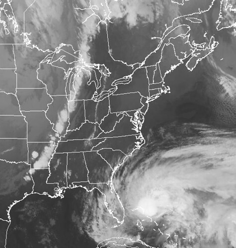
Above: The impending clash of titans — a strong trough of low pressure (a.k.a. cold front) that would probably have produced a powerful Nor’easter even if no hurricane were present, and Hurricane Sandy, which is expected to join forces with the trough to create an epic storm of historic proportions.
* * * * *
“The more data I see, the more I think we’re going to be talking about this storm for decades.”
That’s what meteorologist Nate Johnson said last night on the WeatherBrains live show about Hurricane Sandy. It’s a sentiment I keep seeing expressed again and again, in various forms, by pretty much everyone with pertinent meteorological knowledge. Not just serial alarmists, but everyone. (That includes plenty of AGW skeptics, for what it’s worth. This isn’t a global warming hypestorm. This is, potentially, a truly historic weather event, regardless of your stance on climate change.)
When you look at the data — at the best information presently available — you just can’t escape the conclusion that Sandy appears increasingly likely to be an unprecedented and extremely serious storm, as the Capital Weather Gang writes:
With computer models locked in on the eventuality of a punishing blow for East Coast from Hurricane Sandy (with the latest model runs favoring the northern mid-Atlantic), analyses suggest this storm may be unlike anything the region has ever experienced.
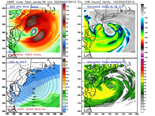
Model simulations have consistently simulated minimum pressures below 950 mb, which would be the lowest on record in many areas.
“Below 950 mb” is an understatement. Last night, a run of the HWRF model forecast an impossible-seeming 922-millibar storm at landfall (see below). That was Hurricane Andrew’s intensity when it hit Florida in 1992! The GFS and Euro models have also shown very low pressures in various models runs. Realistically, the models are probably overstating things a bit — Sandy probably won’t get quite that intense (and even if it did, its winds wouldn’t be anywhere near Andrew-like levels, because it will have a much, much wider and more diffuse circulation — in other words, gale- and hurricane-force winds over a huge area, but no central area of Category 3, 4 or 5 type winds) — but when the models are ranging from the 920s and 930s to more “reasonable” values in the 940s and 950s, you can’t help but take the storm seriously. The “perfect storm” was only 972mb! Anything below 960mb is pretty epic and historic.
It isn’t just the barometric pressure that has folks alarmed, of course. So many of the potential tracks would bring devastating coastal flooding. The official NHC track could be calamitous for Delaware Bay. The latest GFS model could bring devastating flooding to the shores of Long Island Sound. And of course there is the New York Harbor nightmare. Or, Washington, D.C., the Delmarva and Chesapeake Bay could be crushed. Or the New Jersey shore could. It’s important to emphasize that we don’t know exactly where Sandy will go, and won’t for a while yet. But at this point, it’s hard to find a reasonably likely track that wouldn’t be a serious disaster for someone, in a region that’s so heavily populated.
Moreover, because Sandy is so huge, its impact will be widespread and long-lasting. North and east of the landfall point, its relentless onshore winds will pile up a storm surge over a wide area through multiple tide cycles — making each successive high tide higher than the previous one. With astronomical high tide on Monday, this is a particularly big problem. AccuWeather meteorologist Mike Smith (an AGW skeptic and non-alarmist) writes on his blog: “Based on some media coverage I’m seeing, the threat of flooding in coastal areas is being underplayed. Especially, if you live ten feet or lower above sea level, you need to be prepared to evacuate should the order be given.” I completely agree with that statement.
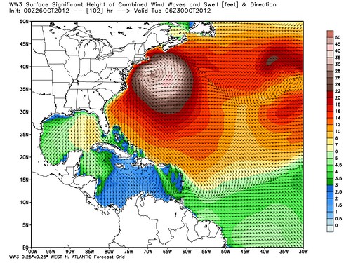
While we’re on the topic of ocean flooding, models suggest Sandy will stir up the ocean to an almost unbelievable extent, with offshore waves that are, well, just huge:
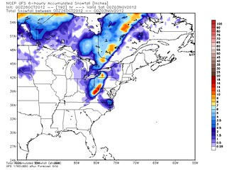
And then there’s the potential rainfall… and snowfall!
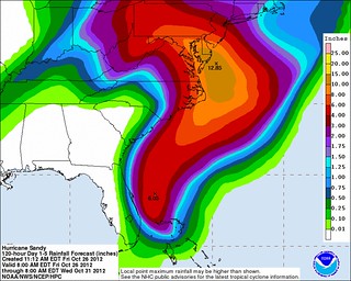
(The total rainfall would actually be greater than the graphic at left shows, because that’s only a 5-day forecast, going through Wednesday morning, when the storm is forecast to be inland over Pennsylvania, still dumping lots of rain.)
I’m picking up some skepticism of all this “hype” from commenters and on Twitter, by folks who say this is “just” a Category 1 hurricane or “just” a big Nor’easter, and the media is jumping the gun again, like they did with Irene and various other storms. (Actually, Irene arguably lived up to much of the hype, but I’ll leave that argument for another day.) This sort of critique, which is often more rote media criticism than actual storm-specific analysis, routinely fails to recognize that weather forecasting is an inherently uncertain probabilistic enterprise — meaning most worst-case scenarios, warned of days in advance, don’t happen; if we wait to discuss them until they’re likely or certain to happen, it’s too late to prepare — so you have to judge the validity of “hype” contemporaneously, not with the benefit of hindsight. And, given that fact, the “overhype” critique is particularly misguided and wrong-headed in the present situation. The currently available data suggests, almost unanimously, that the universe of realistic scenarios for Sandy ranges from “bad” to “very, very bad.” The moment that data shifts, and starts suggesting a lower probability of disaster, I’ll let you know, just as I did with Irene and Isaac when the data shifted toward more favorable outcomes in those cases. But right now, that’s just not what the data says.
Some folks — local TV news departments probably being among the worst offenders — will always hype every semi-serious storm, and even more folks (including national cable news writ large) routinely fail to walk back previously-justified hype when the data changes, or events on the ground prove the data wrong. But those of us who take our roles seriously only hype those storms that deserve it, and tamp down the hype when conditions change such that the storm no longer deserves it. Right now, this storm deserves it.
It’s also critically important to remember yesterday’s quote from meteorologist Brad Panovich: “Don’t let the Category of the storm or whether it’s ‘just’ a Nor’easter dictate your response. Your personal memories of previous storms are no use in this unique situation.”
Why, you may ask, is it so unique? Why is all of this happening? Why is a Category 1 hurricane so potentially devastating? The Capital Weather Gang gives the most succinct answer I’ve seen:
[T]he clash of the cold blast from the continental U.S. and the massive surge of warm, moist air from Hurricane Sandy will cause the storm to explode and the pressure to crash.
This is highly unusual for a variety of reasons, about which, more after the jump.
The Weather Channel’s Hurricane Specialist, Bryan Norcross, does an excellent job of explaining what’s happening:
Isn’t it strange that a hurricane in the Bahamas would somehow turn into a monster mega-storm and slam into the Northeast at the end of October? Aren’t hurricanes supposed to weaken as they move north over cold water? What the hell is going on?
The answers are… yes, yes, and we’re not completely sure. This is a beyond-strange situation. It’s unprecedented and bizarre. Hurricanes almost always bend out to sea in October, although there have been some exceptions when storms went due north, but rarely. No October tropical systems in the record book have turned left into the northeast coast.
The strong evidence we have that a significant, maybe historic, storm is going to hit the east coast is that EVERY reliable computer forecast model now says it’s going to happen. The only way we can forecast the weather four or five days days from now is with the aid of these super-complex computer programs run on supercomputers. The two best, the European and the U.S. GFS (Global Forecast System) run by NOAA, are now in reasonable agreement that there IS going to be an extraordinarily unusual confluence of events that results in a massive storm.
The upper-air steering pattern that is part of the puzzle is not all that unheard of. It happens when the atmosphere gets blocked over the Atlantic and the flow over the U.S. doubles back on itself. Sometimes big winter storms are involved.
The freak part is that a hurricane happens to be in the right place in the world to get sucked into this doubled-back channel of air and pulled inland from the coast.
And the double-freak part is that the upper level wind, instead of weakening the storm and simply absorbing the moisture – which would be annoying enough – is merging with the tropical system to create a monstrous hybrid vortex. A combination of a hurricane and a nor’easter.
At least that’s what the models are saying. And since all of the independent models are saying something similar, we have to believe them and be ready. …
The hope we have is that the computer models are not handling this unusual situation well, and are predicting a stronger storm than we get. But, we can’t bet on it. Even a weaker version will likely mean a nightmare for millions.
Another excellent write-up about the ingredients creating this unique situation can be found at this site, courtesy of Bob Henson:
What makes Sandy so unusual? And how might it rewrite weather history?
As I write, Sandy is in the Bahamas…and projected to move northeast from the Bahamas, as hurricanes so often do. But then — thanks to a strong upper-level storm dipping into the eastern U.S., and an extremely strong center of high pressure toward Greenland — the storm is expected to take a grand counterclockwise loop and arc northwest, which would bring it to the U.S. coast by Tuesday and drive it well inland.
The official National Hurricane Center forecast issued at 5:00 p.m. EDT Thursday has the center of Sandy making landfall early Tuesday in New Jersey while moving toward the northwest. To say this path would be unusual is a major understatement. Few if any hurricanes in the last 100 years have struck the mid-Atlantic or New England with quite such a dramatically hooking path …
Unfortunately, this curving path would also maximize Sandy’s time close to the warm waters of the Gulf Stream. … [T]emperatures are running 1-2°C above average off the mid-Atlantic coast. …
Leading forecast models are producing spectacularly low pressures at the center of Sandy. … While a couple of hurricane landfalls in Florida have produced pressures in this range, most cities in the Northeast have never reached such values … [T]he landfall pressures with Sandy may be less extreme than predicted, because of known model difficulties in handling tropical systems moving into midlatitudes. However, all-time records could still be well within reach at some locations. …
Sandy’s hooking path and low pressure will help funnel mammoth amounts of seawater toward the Atlantic coast north of wherever the center makes landfall. Thanks to the massive high pressure to the north, and a separate low pressure center far to the east, models project a ribbon of easterly winds all the way from Europe to the mid-Atlantic as Sandy approaches. In addition, there’s a full moon on Monday afternoon, which will exacerbate any storm tides. All of these factors should help strengthen a rare and powerful wave- and surge-generating machine. …
New York City is at particular risk for serious impacts from storm surge. If Sandy moves inland on the New Jersey coast, huge amounts of water will flow toward New York’s harbor, so predictions of storm surge will be critical. … “I am personally very concerned about storm surges in New York City,” says [Philip Orton of the Urban Ocean Observatory of the Stevens Institute of Technology] … “City managers and scientists agree that we’re not ready for a 100-year flood event, in major part because we haven’t had one in well over 100 years,” Orton says. …
Inland flooding is also a serious threat with Sandy. NOAA guidance and recent model runs suggest that 5–10” of rain could fall along and near the storm’s path. Heavy snow is even possible along some of the highest terrain of the Appalachians. …
Perhaps the biggest potential threat from Sandy for millions of people inland is the risk of power outages and tree loss. Winds may not be sustained above hurricane force, especially inland, but strong gales of 50–60 mph with higher gusts could easily stretch across a vast swath of the most heavily populated part of the country. These winds may be enough to bring down many trees and power lines, especially when accompanied by soil-loosening rains. If enough utility customers are affected, it could take days if not weeks to restore power to some areas — potentially affecting the November 6 elections.
Mike Smith — again, a climate change skeptic, FWIW — puts it this way:
A very prominent and respected National Weather Service meteorologist wrote on Facebook last night, “I’ve never seen anything like this and I’m at a loss for expletives to describe what this storm could do.”
Yes, I’ve never seen anything like it either nor have our modern meteorological tools. As I wrote yesterday afternoon, we don’t know whether our tools are up to the task because no storm of this nature has occurred in the modern meteorological era.
That last bit is the hope we can still cling to — that the computer models are all getting it wrong, because they’ve never seen a storm like this before. But that’s not something we can assume. We can hope for it, but we have no right to presume it will be true. So folks in harm’s way have got to prepare.
How should they prepare? Well, listen to trusted local information sources, including local officials and media sources, for starters. In addition, here are some helpful resources:
• Coalition of the Swilling’s preparedness guide
• Mike Smith’s preparedness tips
• Washington Post article on how to prepare
Also, if you have travel plans that require you to be on an airplane in the affected region this weekend or next week, read this and take it to heart (more smart advice from Mike Smith). Maybe even print it out and bring it on your trip, if you aren’t just cancelling/postponing your trip altogether.
Above all, if you’re in a flood-prone coastal location, be prepared to “Get The Hell Out” if you’re ordered to evacuate ahead of the storm. And if you’re in a flood-prone inland location, be ready to leave on a moment’s notice if a rain-caused flash flood threatens.


Join the conversation as a VIP Member