

[NOTE: check the blog homepage and follow me on Twitter for the very latest.]
* * * * *
Isaac remains a 65 mph tropical storm as of 11:00 AM EDT. It continues to try to get better organized, but has yet to form an eye or take a more “classic” appearance on satellite.

If New Orleans and the Gulf Coast survive this storm relatively intact, they ought to designate a Patron Saint of Dry Air, and thank that saint. If it weren’t for that single atmospheric feature — dry air getting sucked into the circulation — this storm could well be a monster right now, bearing down on New Orleans along a worst-case track. (It’d be worse than Katrina, in terms of the track.)
Instead, even after last night’s re-centering, Isaac is still struggling to get its act together with respect to its internal core structure, which is the only missing prerequisite to significant intensification right now. The overall wind shear is light, the outflow is good, and the water is warm (probably not deeply warm enough for Cat 4/5, but certainly warm enough for Cat 3). But, as I explained in my post four days ago wondering whether Isaac might never become a hurricane (still technically a live question), a storm can’t intensify significantly without a well-structured inner core, no matter how “perfect” the conditions otherwise are. And it’s dry air that’s consistently prevented Isaac from developing a healthy core.
Unfortunately, the possibility of shedding that dry air at the last minute, and intensifying rapidly just before landfall, remains very much alive. It might not happen, but it might, and that’s the chief remaining cause for concern. (Well — the size of the storm, its somewhat slow speed, and the resulting increased & broad-based storm surge and heavy flooding rains are also big concerns.) As the NHC explained this morning:
UNTIL THE DRY AIR MIXES OUT…EROSION OF THE INNER-CORE CONVECTION WILL LIKELY CONTINUE UNTIL ISAAC APPROACHES THE NORTH-CENTRAL GULF COAST IN ABOUT 24 HOURS. AT THAT TIME…INCREASED FRICTIONAL EFFECTS FROM THE GULF COAST LAND MASS IS EXPECTED TO CONTRIBUTE TO AN INCREASE IN CONVECTION IN THE NORTHEAST QUADRANT…WHICH COULD ENABLE THE STRENGTHENING PROCESS.
To illustrate how this might transpire, it’d helpful to look at the most recent run of the most reliable American computer model, the GFS. The model intensifies Isaac more than the NHC is predicting — the NHC forecast intensity tops off at 90 mph; the GFS gets up to 112 mph 99 mph, as you’ll see below — and the GFS’s landfall point is a bit west of the NHC’s. But the general intensification trend is similar. Because Dr. Ryan Maue’s excellent Weather Bell Models site gives us a printout of the GFS projection for every 3 hours between now and landfall, we can go through, step by step, and get a sense of how the next 36 hours might play out. Please don’t focus on the precise details — this is only a single computer model run, not an official forecast, and it is certainly subject to change. I just want to give everyone a general overview of the sort of storm evolution that might occur, according to this trusted model. Don’t make life-or-death decisions based on this model; that’s what the NHC forecast is for. This is just for illustrative purposes.
[UPDATE: As indicated by the crossed-out “112 mph” above, I made an embarrassing and critical error here. I forgot that the wind totals in these graphics, which I converted from knots to mph, also have to be converted from flight level to surface level, which entails a reduction of 10 to 15%. I know that’s true of flight-level winds from recon flights and the like, but I totally forgot about it in this context. That helps explain much of the apparent discrepancy between the NHC and GFS forecasts (though the GFS was still a bit more bullish) and forces me to modify some of the text below. I apologize profusely for the error, which I have corrected by reducing each affected figure by 12%. These corrections are made without strikethroughs, for ease of reading.]
First, here’s how the GFS portrayed Isaac as of its “initial” position, at 8:00 AM Eastern Time, with an estimated 55 mph winds and 991.2 mb pressure.
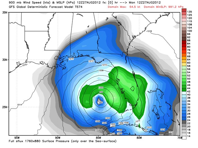
Now, let’s see how the GFS predicted Isaac would evolve from there. (Link goes to the image.)
Monday, 11:00 AM: 56 mph, 989 mb
Monday, 2:00 PM: 58 mph, 987 mb
Monday, 5:00 PM: 60 mph, 985 mb
Monday, 8:00 PM: 65 mph, 983 mb.
The 8:00 PM snapshot shows the first sizable three-hour jump in wind speed — so don’t be surprised if any changes remain incremental all day today. Here’s what it looks like:
Then, according to the GFS, Isaac largely stands pat for about six hours, before beginning to strengthen more rapidly early Tuesday morning:
Monday, 11:00 PM: 65 mph, 982 mb
Tuesday, 2:00 AM: 68 mph, 980 mb
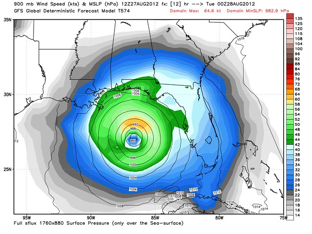
Tuesday, 5:00 AM: 75 mph, 978 mb
So Isaac finally becomes a hurricane in the wee hours of the morning, per the GFS, looking like this:
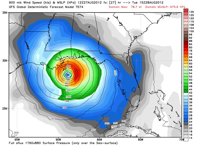
Tuesday, 8:00 AM: 77 mph, 977 mb
Tuesday, 11:00 AM: 80 mph, 976 mb
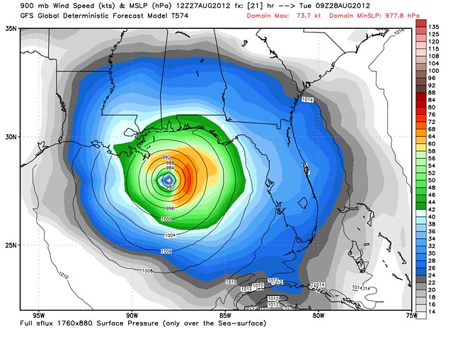
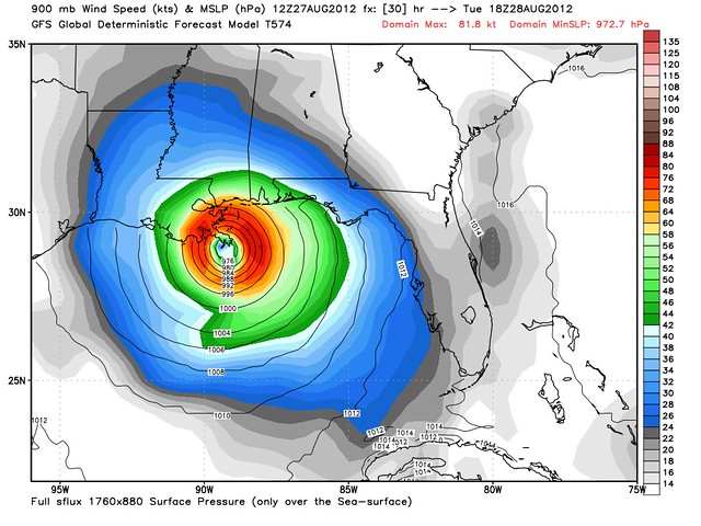
Tuesday, 2:00 PM: 82 mph, 973 mb
At this point, it’s tomorrow afternoon, and Isaac is making landfall in Plaquemines Parish, near the mouth of the Mississippi River. According to the GFS (and the official NHC forecast), it will be intensifying as it does so, which is bad news, as intensifying hurricanes are more dynamic, bring heavier wind gusts and generally better organized than steady-state or decaying hurricanes of the same stated intensity. (On the bright side, late intensification — as opposed to earlier intensification and then steady state for a long time before landfall — means Isaac will have less time to build up a massive storm surge ahead of it, a la Katrina and Ike. Given the storm’s size, that’s a very good thing.)
Anyway, GFS has Isaac reaches the borderline of Category 2 status between 2pm and 5pm tomorrow, as it passes over the marshes of Plaquemines:
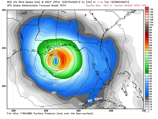
Tuesday, 5:00 PM: 94 mph, 969 mb
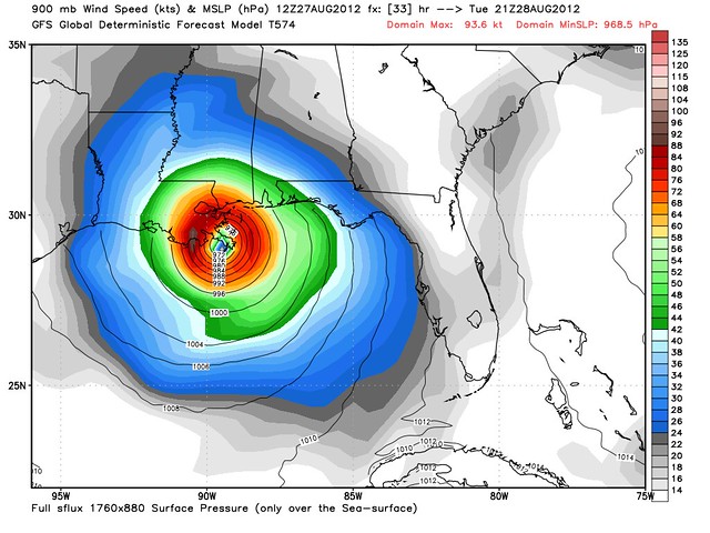
Note the big jump between those last two frames, from 82 mph to 94 mph in just three hours tomorrow afternoon, during landfall in Plaquemines Parish. Not good. But again, the point isn’t the detail of exactly when or where the GFS thinks this will happen, which is subject to change, and is not reflected by the official forecast at this time. The point, rather, is that this sort of thing can happen, and can happen quite close to land, with little or no warning. That’s why the exact track and timing are so important. A storm that might intensify that quickly is a storm that might turn into a mid-range Category 3 a few hours later, if it had just a little bit more time over water to get there. (Conversely, it’s a storm that might remain a low Category 1 or Tropical Storm if it had just a little bit less time.) It looks like Isaac will probably take too long to start strengthening, and thus run out of water before catastrophic last-minute rapid deepening can happen — indeed, contra the GFS, it might even run out of water before it can strengthen much at all — but these model maps illustrate why the difference between a fearsome monster and “overhyped” “dud” of a storm can be a matter of a few hours and/or a few dozen miles in either direction.
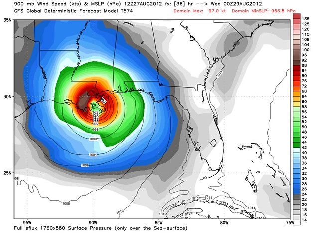
Anyway, the next GFS projection takes Isaac up to solid Category 2 status:
Tuesday, 8:00 PM: 99 mph, 967 mb
After that, in the GFS’s forecast, land interaction begins to weaken the storm.
Tuesday, 11:00 PM: 97 mph, 970 mb
Wednesday, 2:00 AM: 99 mph, 974 mb
Wednesday, 5:00 AM: 90 mph, 977 mb
Wednesday, 8:00 AM: 84 mph, 978 mb
The GFS proceeds to show Issac almost stalling over the bayous, and actually gaining a tiny bit of strength midday Wednesday while sitting over that marshy land mass, which would be bad news in several respects. (Primarily due to flooding rains, but also because of a prolonged wind and surge battering.) In the GFS scenario, Isaac retains hurricane or high-end tropical-storm force winds for more than 24 hours over land. I’m not sure how realistic that scenario is, so I won’t dwell on it right now, but it’s certainly something to watch. [UPDATE: I will say this: intensification during landfall can definitely lend itself to slower-than-usual weakening over land. And so can passage over wet, marshy areas. Louisiana ain’t Cuba. I do think the inland wind aspect of this storm is something to watch, along with the huge threat of inland flooding rains, of course.]
By Thursday afternoon, the GFS picture of Isaac looks like this:
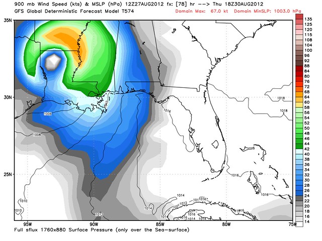
This would be a significant wind and rain event for all of Louisiana, if it came to pass. But again, my point here is not to “predict” these details, and please remember that this is just one “run” by one computer model, not the official forecast. My point is to illustrate the general parameters of the storm evolution that might occur, and to point out how small differences can have a huge impact on the outcome.
P.S. New Orleans Mayor Landrieu is sticking with the plan of “sheltering in place.” Disregarding the notion of preparing for a storm one category worse than the forecast, he is telling residents to prepare for a “strong Category 1” (which is precisely what the forecast says), adding, “The good news is it’s not a Category 3.” He’s probably right, of course — and if so, he’ll be hailed for handling the storm well, and nobody will ever read my post bashing him again. But in the less likely but still plausible (20% chance? 10%? 5%?) event that Isaac strengthens dramatically before landfall and brings truly devastating conditions to New Orleans — rather than just a rough, windy, rainy day or two, with minor-to-moderate flooding — history will judge him harshly.
The fact is, Landrieu chose to prepare for the most likely case, and NOT to prepare for the worst. So, hopefully the worst won’t happen. It probably won’t. It usually doesn’t. I still disagree with his decision, and always will, based on the contemporaneous information available yesterday (not 20/20 hindsight) about what the realistic worst-case scenario was. But I do understand the reluctance to evacuate under those maddeningly uncertain circumstances, and I hope it works out for him (because I hope NOLA doesn’t get crushed by Isaac, obviously).


Join the conversation as a VIP Member