Isaac’s Center Re-Forms; Euro Model Shifts West
[NOTE: check the blog homepage and follow me on Twitter for the very latest.]
* * * * *
In an overnight development with major implications for both the track and intensity of Tropical Storm Isaac, the storm’s center of circulation has “relocated” underneath the ball of convection (i.e., thunderstorms) that has been blowing up all evening, previously to the north of the center.
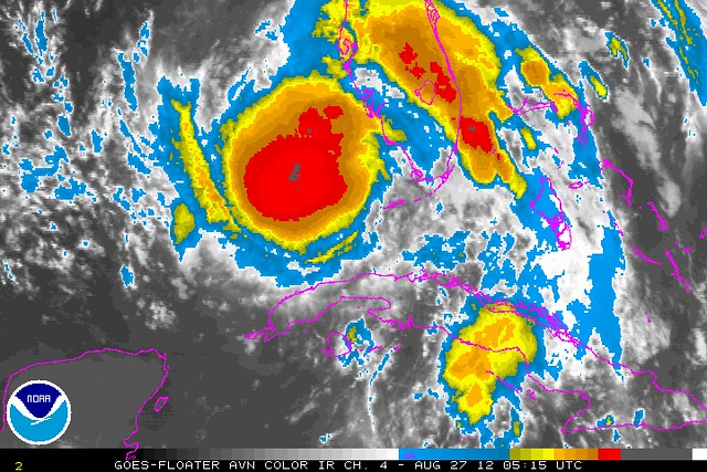
This happens sometimes, and it means Isaac’s strengthening will likely begin in earnest now. I wouldn’t be surprised if he’s a hurricane by morning.
Meanwhile, by spontaneously “moving” 55 miles or so to the northwest of its previous position, Isaac’s center may now be on a different track trajectory, and/or may react slightly differently to the steering currents that drive the storm’s movement. The most recent set of computer model runs are less useful now, since they were based on an incorrect initial storm position, so we’ll have to see a new set of model runs to begin to understand what impact this relocation of the center will have on the track. It seems plausible that it could result in a more easterly track — perhaps increasing the risk to the Mobile area or the Panhandle, or maybe increasing the risk to New Orleans as opposed to the TX/LA border region — but we’ll need to see some model runs to be sure.
Speaking of model runs, there was also another significant development moments ago: the 00Z European model, i.e. the ECWMF or “Euro,” has shifted its landfall point from the AL/FL border region west to the LA/MS border region. It has also decreased its landfall intensity to Category 1. So this brings the Euro and the GFS more in line with one another, specifically by way of the European model joining the American model further west (U-S-A! U-S-A!). This implies the possibility of a dangerous consensus for New Orleans (ignoring the intensity issues for the moment, since that’s much harder to predict). But course, as I just said, the center relocation could throw off any such consensus, so we’ll just have to wait and see what the various 06Z models (and eventually, the 12Z Euro) show.
I’d love to stay up for the 5:00 AM EDT advisory and discussion from the NHC, but I’ve got to get to bed now — it’s 12:30 AM local (Mountain) time, I’ve gotten limited sleep all weekend due to Isaac-tracking, and I’ve got both work and my 4 1/2 year old daughter’s first day of kindergarten tomorrow. So I need to Occupy My Bed, as it were.
I’ll do my best to keep this blog updated tomorrow, and I’ll also inevitably be tweeting extensively throughout the day about Isaac.


It’s also sucking in dry air from the Yucatan, and is over the deep part of the Gulf where it’s churning cold water from the depths to the surface. Not getting past Cat 1. If it hits here in the New Orleans area, I’ll probably sleep through it.
Interesting development this morning. I went to Intellicast to get the latest storm path and their website says no active storms are being tracked. Perhaps afraid of liability issues or all the hits are crashing their server?
Where did PJ get this Loy dude? Amazing. Amazingly bad.
May, may, might, plausible, may, might, could.
Wouda, shouda, couda.
We gotta a guy in the MOUNTAIN timezone reporting on hurricanes – strike that a – TS. Whoever this Loy dude is he is getting his info from the wrong sources.
If Isaac comes close to hitting New Orleans, will the strong right shoulder of the storm/hurricane force a storm surge into Lake Ponchartrain? Is NO better prepared for the surge from the lake side now? I have been on the edge of a few hurricanes and they are even more interesting after experiencing one or two.
Thanks for taking the time to blog on this Brendan!
“churning cold water from the depths”..?
I don’t think hurricanes do that at all. Most important I would think, is that the Gulf is hot. Water temps as reported by NOAA bouys are all in the mid-80′s. That is high enough to pump energy into the hurricane. That’s what happened when Katrina romped by: the surface waters of the Gulf pumped a bi-jillion ergs of heat into the storm and ended up dropping about 4 degrees in temp. (A bi-jillion is a half a jillion, BTW). More seriously, the amount of energy transferred can be usefully measured in ‘Hiroshimas’: it’s massive.
You would prefer that I express uncertainties in terms that imply certainty? I think you don’t understand the uncertainties and probabilities of hurricane forecasting very well. Read the NHC discussions. They’ve been emphasizing how this storm is unusually difficult to forecast. My language just reflects that. As for my “sources,” they’re the same models the NHC looks at, plus the NHC discussions and forecasts themselves. Take issue with my analysis if you wish (though it hasn’t really been much different from the NHC and the mainstream thinking on this storm, so I’m not sure what the issue would be), but there’s nothing wrong with my “sources.”
No, I understand uncertainties of hurricane forecasting just fine. I read the NHC crapola. I look at the “models”.
But if you want to get better sources get on down to florida and talk to the locals. Like many things in life this takes experience.
“Mainstream thinking” LOL.