

The Atlantic tropics have been eerily quiet over the last couple of weeks. Indeed, the big headline has been that we turned the calendar to September without having a hurricane, the first time since 2002 that’s happened. Overall, August was remarkably quiet, despite the fact that conditions broadly favor development:
August 2013 had one of the lowest Accumulated Cyclone Energy (ACE) totals on record for an August in the Atlantic. … This year’s combination of no El Niño, warm [sea surface temperatures], and an exceptionally low August ACE is an event unparalleled in the historical record, going back to 1966. … The main reason for the quiet August has been the large amount of dry, stable air over the Atlantic. This dry air has two sources: the Sahara desert of Africa, and sinking air from aloft, which warms and dries as it sinks. Even so, I find it highly perplexing that activity has been so low when all of the other factors–lack of an El Niño, low wind shear, an active African Monsoon spitting out plenty of tropical waves, and above average ocean temperatures–have favored development.
But we may now finally have a candidate for significant tropical development. “Invest 97L” near the Lesser Antilles, a wave that emerged from Africa a week ago (and was written off by computer models days ago), seized the attention of the weather community Sunday as it took advantage of favorable conditions caused by a split-in-half upper low system (which Jonathan Belles explains further), and started looking unexpectedly robust:
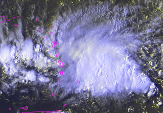
As the convection fired up, 97L also started producing some attention-grabbing long-range computer model forecasts:
Nearing the Caribbean, 97L is starting to get my attention. Could be TS/Hurr by Wed, and near FL by Friday. pic.twitter.com/QR16mYbkZU
— Adrian Linares (@Adriansweather) September 1, 2013
Re: pic.twitter.com/4DbalQcGyH RT @ericburris: Am I the only one thinking that the 0z model intensities for Invest 97-L are a little CRAZY?!
— Brendan Loy (@brendanloy) September 2, 2013
Upgraded HWRF 18z more intense than GFDL with close to major hurricane in 66 hrs for Invest 97L pic.twitter.com/IkaVxyeIpO
— Ryan Maue (@RyanMaue) September 2, 2013
The 18Z GFDL & HWRF bring 97L to a Hurricane in 72 HRS- then tracks toward WNW by Saturday. pic.twitter.com/L2V8IRpYMT
— Jeff Piotrowski (@Jeff_Piotrowski) September 2, 2013
Now, let’s not get carried away here. “97L” isn’t even a tropical depression yet, let alone the major hurricane that some models are predicting it will eventually become. It may very well fizzle entirely, or become another Chantal/Dorian/Erin — a minor storm that develops, but never becomes a significant threat. Notably: “Several of the models indicate that this tropical wave will, in fact, become a hurricane. However, the advanced global models, such as the GFS, show next to nothing at all happening.”
The smart money is that, at a minimum, those bullish intensity models are developing 97L too quickly, for the reasons Dr. Jeff Masters notes:
The main factor keeping the disturbance from developing over the next two days would appear to be the fact that 97L is quite large, and is stretched out from east to west over a wide expanse. Large, elongated systems like 97L usually take several days to consolidate and spin up. Another factor that will likely retard development is the presence of strong surface trade winds over the Eastern Caribbean ahead of 97L, south of the Dominican Republic. These strong trade winds are a common feature of the Eastern Caribbean, and make the region something of a hurricane graveyard. As the surface wind flow to the west of 97L accelerates into this wind max, air will be sucked from aloft downward towards the surface, creating sinking air, interfering with the formation of thunderstorm updrafts. The best chance for development of 97L would appear to be on Wednesday or Thursday, when the disturbance reaches the Central Caribbean.
Here’s a graphical representation of that concept:
MT @TropicalTidbits: Sun. PM video discussion on #97L: http://t.co/psN4U5yGKO | Good stuff as usual. Levi's forecast: pic.twitter.com/Wh2gdL8Y5y
— Brendan Loy (@brendanloy) September 2, 2013
By the way, that video update by Levi Cowan really is very helpful and informative. If you want to understand what’s going on with 97L, I recommend taking 8 minutes to watch it:
Another important caveat: if this system does become “Gabrielle,” we cannot even begin to know where, specifically, it will go, because any continental landfall would be many days away — plus, storms that don’t exist yet are very difficult to accurately forecast! So there’s no cause for #PANIC or hype. It bears watching for anyone in Florida or anywhere on the Gulf Coast, but guidance more specific than that is impossible. As Brian McNoldy writes:
We will clearly have to watch this closely, as model solutions range from near-nothing to a Category 3 hurricane in 5 days near Jamaica. Right now, it’s too soon to get concerned, but not too soon to pay attention.
I’ll certainly be paying attention. Stay tuned to this blog and my Twitter account for the latest.


Join the conversation as a VIP Member