

As expected, early August was quiet in the Atlantic basin. After Resurrected Zombiestorm “Dorian the White” finally died for good two weeks ago Saturday, we had more than 11 days without an active tropical cyclone. But now that the Saharan dust has subsided somewhat (although not completely!) over the prime hurricane breeding grounds, things can get active again — and they are doing so.
For a while Tuesday and Wednesday, “92L” in the Caribbean and the system off the African coast were in a race to become “Erin.” The African wave won that battle, becoming Tropical Depression 5 last night at 11:00 PM Eastern Time, and getting an upgrade this morning at 8:00 AM to Tropical Storm Erin. As the Washington Post‘s Capital Weather Gang notes, this quick spin-up resulted in “the very rare occurrence of tropical storm warnings being issued for parts of the Cape Verde islands!”
Right now, Erin is a minimal tropical storm, with 40 mph winds. She is expected to slowly strengthen for the next 2 to 3 days as she moves west-northwest; the official forecast has Erin attaining 60 mph winds by Saturday. But then a scenario similar to Chantal and Dorian will likely kick in, as Dr. Jeff Masters explains:
[T]he waters beneath Erin will steadily cool to a marginal 26°C by Friday [here’s a map showing that -ed.], and the atmosphere will steadily get drier, as the storm encounters the Saharan Air Layer (SAL), discouraging development. Erin’s west-northwest motion will cut the storm off on Sunday from a moist source of air to its south–the semi-permanent band of tropical thunderstorms called the ITCZ (Inter-Tropical Convergence Zone.) The storm should weaken beginning on Sunday. …
We may see a situation like occurred for Tropical Storm Dorian in late July–intensification to a 60 mph tropical storm, followed by a slow decay and dissipation. The latest run of the GFS model calls for Erin to dissipate well before reaching the Lesser Antilles Islands.
Not all of the computer models agree on that last part, as the National Hurricane Center notes in its 11am EDT discussion: “THE GLOBAL MODELS AND THE HWRF SHOW A WEAK OR DISSIPATING SYSTEM BY DAY 5…HOWEVER THE SHIPS AND LGEM SHOW LITTLE CHANGE IN INTENSITY OR EVEN STRENGTHENING.” The NHC’s official forecast “leans a little toward the weaker solution,” taking Erin back down to 40 mph by Tuesday.
What about Erin’s track? As I mentioned, she will move WNW for the next several days, which would tend to imply she’ll be a “fish” storm, staying safely out to sea (like most storms historically near her location). But, again like Chantal and Dorian, Erin’s expected weakening is expected to result in a more due-west track by late this weekend and early next week. Again quoting Dr. Masters: as Erin starts to “weaken beginning on Sunday, [this] would result in Erin turning more to the west as the east-to-west blowing surface trade winds begin to dominate the steering of the shallower storm.” Hence the expected left turn on the official NHC track. But as with the intensity forecast, and closely related thereto, there is disagreement among the models (and among meteorologists — see what Jim Cantore said, for instance). NHC writes:
THE [COMPUTER MODEL TRACK] GUIDANCE IS IN GOOD AGREEMENT ON [A WEST-NORTHWEST] MOTION CONTINUING FOR THE NEXT COUPLE OF DAYS. BY DAY 3…THE SPREAD IN THE GUIDANCE INCREASES. ON THE RIGHT SIDE OF THE GUIDANCE ENVELOPE THE GFDL…GFDL ENSEMBLE MEAN…ECMWF AND UKMET SHOW A NORTHWESTWARD OR WEST-NORTHWESTWARD MOTION. THE FIM…GFS…GFS ENSEMBLE MEAN AND HWRF ALL SHOW A WESTWARD TRACK…CONSISTENT WITH A SHALLOWER SYSTEM BEING STEERED BY THE LOW-LEVEL FLOW. THE NHC FORECAST AT DAYS 3 THROUGH 5 CONTINUES TO FOLLOW THIS SOUTHERN CAMP OF MODELS.
Here’s a good illustration of the divergence among the models, as to both track and intensity:
Via @EdPiotrowski, a nice image showing computer model disagreement (or "spread") on both track & intensity of #Erin: pic.twitter.com/acGZJ3pyDx
— Brendan Loy (@brendanloy) August 15, 2013
To summarize: By early next week, Erin will likely be either a weak (perhaps even dissipating or dissipated) storm moving due west, or else a stronger storm moving more northwesterly, toward a “fish” track out to sea. Either way, it’s nothing to worry too much about at the moment. We’ve got a long time to watch it, which means things can change, but for the moment, it seems fairly unlikely to become a big U.S. threat.
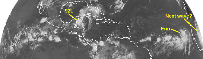
Closer to home, what about the system in the Caribbean, known for the moment as “Invest 92L”? Right now, it’s basically just a cloud bank off Belize (photos here). But what does the future hold? Is 92L likely to become Tropical Depression Six, and eventually Tropical Storm Fernand?
The answer for now is “probably,” though it looks a bit less certain than yesterday, when 92L was given a 70% chance of developing during the next 48 hours, and an 80% chance during the next 5 days. Those numbers are down to 50% and 60%, respectively, in the current NHC outlook. There continues to be disagreement among computer models, and the individual runs of each model, about whether 92L will amount to anything at all. (Compare, for instance, the this map with this map.) Dr. Masters, for his part, remains fairly bullish that 92L will at least become a depression:
The tropical wave in the Western Caribbean near the Yucatan Peninsula (92L) is growing more organized this morning, after an evening when it lost most of its heavy thunderstorm activity. Satellite loops show a modest-sized area of heavy thunderstorms that are increasing in intensity and areal coverage, but there are a no signs of a surface circulation. … Wind shear is a moderate 10 – 20 knots over the the wave, which should allow slow development today until…it [goes] over the Yucatan Peninsula Thursday afternoon. …
92L will trek across the Yucatan Peninsula Thursday evening and arrive in the Southern Gulf of Mexico on Friday, when it will have the opportunity to strengthen. The 06Z Thursday SHIPS model forecast predicts that 92L will remain in an area of low to moderate wind shear through Saturday, and ocean temperatures will be a favorable 29 – 30°C. … Given all these factors, 92L should be able to become at least a tropical depression by Saturday.
The good news is that the realistic worst-case scenario right now doesn’t look very bad. We’re probably looking at either: (1) a weak 92L or TD6 or a minimal TS Fernand tracking west toward Mexico, or (2) a moderate tropical storm getting pulled north toward the central Gulf Coast. Nobody is expecting this thing to blow up into a monstrous Gulf hurricane, so there’s no need to #PANIC when you see that some computer models are targeting vulnerable cities like New Orleans or Mobile:
From Mexico to Mobile. RT @WBRZ: Here are the AM forecast model plots for Invest 92L. They are ALL over the place! pic.twitter.com/ZYTeaFfak9
— Brendan Loy (@brendanloy) August 15, 2013
The National Weather Service’s New Orleans office says 92L (or “proto-Fernand,” if you prefer) could be a fairly heavy rain event for the region. But this isn’t some sort of impending calamity, so let’s not get carried away with hype.
Having said all that, it’s really difficult to predict with any confidence what’s going to happen, as Capital Weather Gang explains:
It’s hard to say what [92L’s] future will be once it enters into the Gulf of Mexico, because there might not be much left to look at [after it crosses the Yucatan Peninsula]. If it does manage to re-organize, it will take a while, so shouldn’t become anything more than a tropical storm. Of course, once a storm is in the Gulf, it has to make landfall somewhere, and right now, the model consensus is north toward Louisiana, but if it dissipates, a more westward track into Mexico or Texas is likely.
The timing should be around Saturday evening into Sunday morning, but it will just be an anti-climatic increase in rain and thunderstorms. Over the next five days, areas along and to the right of the path can expect 4”+, with locally higher amounts. Given the huge uncertainty in the track, there is also large uncertainty in the rainfall forecast.
Once this system is back over the water tomorrow, we’ll have a better idea of its future track and intensity… right now, there are too many significant unknowns.
Lastly, there’s the possibility that, if 92L doesn’t ever manage to get its act together, the real “proto-Fernand” could be the healthy-looking wave that’s over Africa right now, which some models predict will develop once it reaches the ocean:
Or could THIS be proto-#Fernand? MT @hurrtrackerapp: A wave over Africa will be monitored for development next week. pic.twitter.com/PrSk3UAE2W
— Brendan Loy (@brendanloy) August 15, 2013
“Fernand,” incidentally, is the one of three “new” names for 2013 on the sextennially rotating name list, along with “Dorian” and “Nestor.” They replace the retired storm names Dean, Felix and Noel.
Anyway… stay tuned, as they say. I’ll update this blog as warranted, and in the mean time, follow me on Twitter for the latest.


Join the conversation as a VIP Member