
Tropical Storm Flossie has — somewhat surprisingly — maintained its strength over the weekend, and appears set to make a direct hit on the Big Island of Hawaii as a moderate strength tropical storm Monday morning. Tropical Storm Warnings are up for most of the state, and residents are anticipating heavy rains, strong winds, dangerous surf and flash flooding, starting as early as 6am local time (noon Eastern Time) on the Big Island and Maui, from what would be the first active tropical storm to actually make landfall in Hawaii in more than two decades.
Here's the official CPHC forecast for #Flossie as of 11pm EDT: http://t.co/yEN0NkWwLU pic.twitter.com/Ym9a4BRJkV
— Brendan Loy (@brendanloy) July 29, 2013
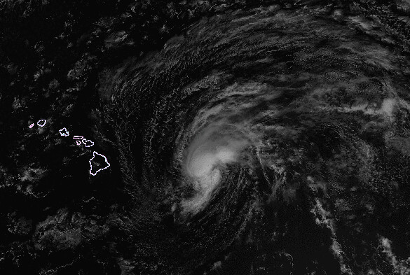
The Central Pacific Hurricane Center (CPHC) expects Flossie’s top sustained winds to diminish from 60 mph to around 50 mph by the time she makes landfall on the Big Island shortly before or around noon Hawaii time (6pm Eastern Time) tomorrow. The latest discussion explains:
THE SYNOPTIC SCALE ENVIRONMENT THAT FLOSSIE IS MOVING INTO WILL GRADUALLY CAUSE SYSTEM WEAKENING. [SEA SURFACE TEMPERATURES] WARM SLIGHTLY ALONG THE PROJECTED PATH OF FLOSSIE…ESPECIALLY WEST OF THE MAIN HAWAIIAN ISLANDS. HOWEVER…WATER VAPOR IMAGERY SHOWS THIS SYSTEM EMBEDDED IN AN AREA OF INCREASINGLY DRY AIR ALOFT DUE TO SUBSIDENCE ASSOCIATED WITH THE UPPER HIGH NEAR KAUAI NOTED EARLIER. AS FLOSSIE MOVES WEST…THIS HIGH IS EXPECTED TO IMPOSE INCREASING NORTH TO NORTHEASTERLY SHEAR ACROSS THE SYSTEM. MODELS CONTINUE TO INDICATE A GRADUAL WEAKENING…
However, there is considerable uncertainty about both the track and intensity of Flossie because of something I’d never heard of until tonight: the “split flow effects of the Big Island.” (Hey, I’m an Atlantic basin guy, cut me some slack!) More here, here and here. (Thanks, Google!) The CPHC writes:
TRACK GUIDANCE REMAINS TIGHTLY CLUSTERED IN THE SHORT TERM…SHOWING FLOSSIE NEAR THE BIG ISLAND AND MAUI MONDAY MORNING…THEN PASSING SOUTH OF OAHU MONDAY NIGHT AND SOUTH OF KAUAI THROUGH TUESDAY. … [HOWEVER,] IT IS IMPORTANT TO NOTE THAT FLOSSIE IS VERY LIKELY TO TRACK ACROSS AT LEAST A PORTION OF THE BIG ISLAND OVER THE NEXT 36 HOURS…INTRODUCING THE DIFFICULTY OF ACCOUNTING FOR TERRAIN EFFECTS ON SYSTEM TRACK AND INTENSITY. POST-BIG ISLAND TRACK AND INTENSITY FORECASTS MAY BE QUITE DIFFERENT ONCE THESE TERRAIN EFFECTS ARE KNOWN.
Fascinating! I’ll try to post more on Flossie tomorrow. For now, here’s the NWS Honolulu radar page.
On another note, remember our “survivor” storm in the Atlantic, Dorian, which…um…didn’t survive after all? Well, from survivor to zombie — or, if you prefer, resurrected storm — she’s trying her best to come back to us now, at the turn of the tide, as Dorian the White. Quoth the NHC:
A TROUGH OF LOW PRESSURE…ASSOCIATED WITH THE REMNANTS OF DORIAN…IS PRODUCING A SMALL BUT CONCENTRATED AREA OF SHOWERS AND THUNDERSTORMS…AS WELL AS GALE-FORCE WINDS…A FEW HUNDRED MILES NORTH-NORTHEAST OF THE LEEWARD ISLANDS. ALTHOUGH THERE ARE CURRENTLY NO INDICATIONS OF A CLOSED LOW-LEVEL CIRCULATION AND A WELL-DEFINED CENTER…ONLY A SMALL INCREASE IN ORGANIZED THUNDERSTORM ACTIVITY COULD LEAD TO THE REFORMATION OF A TROPICAL CYCLONE. ENVIRONMENTAL CONDITIONS ARE MARGINALLY CONDUCIVE FOR REGENERATION…AND THIS SYSTEM HAS A MEDIUM CHANCE…50 PERCENT…OF BECOMING A TROPICAL CYCLONE DURING THE NEXT 48 HOURS AS IT MOVES WESTWARD TO WEST-NORTHWESTWARD AT 15 TO 20 MPH. THIS DISTURBANCE IS EXPECTED TO PASS WELL TO THE NORTH OF THE LEEWARD ISLANDS AND PUERTO RICO TONIGHT AND MONDAY…AND MOVE OVER THE TURKS AND CAICOS ISLANDS AND THE SOUTHEASTERN BAHAMAS ON TUESDAY.
If Dorian re-develops, the computer models seem to genreally take it toward South Florida:
0Z tropical models still targeting S FL…#Dorian http://t.co/Zj1KCEyTas pic.twitter.com/biCttewqjs
— HurricaneTracker App (@hurrtrackerapp) July 29, 2013
NAM Winds about 150 feet off the surface Thursday morning. Re-develops #Dorian & tracks it west-northwest to near FL. pic.twitter.com/q0EVkRch3F
— Wright-Weather.com (@Wright_Weather) July 29, 2013
To be very clear, the bottom map is just one “run” of just one computer model (and not one of the best models either — it’s the NAM, not the GFS or Euro), about a hypothetical storm that doesn’t exist right now (which makes the models even less reliable). So it’s by no means a reliable forecast of what will happen; it’s merely representative of the general sort of scenario that could potentially, perhaps, be on the table, along with various other possibilities (including the distinct possibility that nothing happens at all). Seriously folks, there’s no need for the Andrew talk (even though, yes, 1992’s Andrew did lose its circulation for a while before regenerating and, of course, ultimately becoming a Category 5 monster). Again to be clear, there is no reason to believe anything remotely like that will happen here. But this is an interesting situation. There’s absolutely no need for hype or #PANIC — but we may not be done with Dorian yet. So, stay tuned.
As per usual: you can find more frequent updates by me on Twitter at @brendanloy, and by others on Twitter on Amy Sweezey’s “Wx Tweeps” list.


Join the conversation as a VIP Member