
Tropical Storm Chantal formed on Sunday, well east of the Lesser Antilles, and is now (as of late Monday night/early Tuesday morning) barreling to the west-northwest toward the islands at a screaming-fast forward speed of 26 mph. Its top winds are 50 mph winds, with a thus-far unimpressive minimum central pressure of 1010 millibars.
Chantal will pass over the islands Tuesday, probably slowly strengthening in the process, and will then head for a fateful encounter with Hispaniola late Wednesday and early Thursday. Forecasters are uncertain whether the storm will survive its passage over the mountainous island. If it does, we could be looking at a modest threat this weekend or early next week to the southeastern United States. But more on that in a moment.
It’s unusual, as Dr. Jeff Masters notes, to see a “Cape Verde-type” storm (forming far to the east, out between Africa and the Antilles, in the deep tropics) this early in the season. That makes Chantal the most intriguing storm of the season thus far, and the first one to warrant firing up the Weather Nerd blog for 2013. So, welcome!
That said, Chantal isn’t worthy of much, if any, “hype” yet. The circulation remains relatively weak, and the pressure unimpressive. While modest strengthening is expected between now and landfall in Hispaniola, Chantal is unlikely to become a hurricane or develop a tightly wound circulation during that time, in part because of its rapid west-northwestward movement. As Dr. Masters explains:
Working against [short-term] intensification will be the fast forward speed of the storm–tropical storms moving faster than 20 mph in the deep tropics usually have trouble intensifying. In addition, the Eastern Caribbean is an area where the trade winds accelerate, helping drive sinking air that discourages tropical storm intensification. Dry air will also slow down the intensification process.
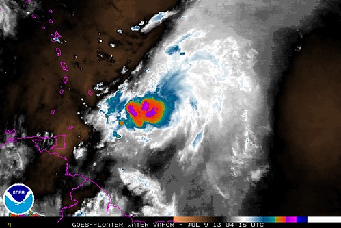
Specifically, Chantal is dealing with the pesky Saharan Air Layer (SAL), the fickle area of desert-dried air that so often stands between early-stage tropical cyclones and development into major storms. So this isn’t likely to be any sort of juggernaut when it reaches the mountains of the Dominican Republic and Haiti. (Though it could certainly cause some flooding and mudslides on the beleaguered island. Hopefully not a catastrophe, though, thanks in part to the same SAL and associated dry air keeping rainfall totals down.)
Chantal’s strength when it approaches Hispaniola is key, because a weak circulation can more easily be ripped apart by the disruption that those mountains cause. Land interaction “may be able to destroy the storm,” writes Dr. Masters, particularly because “wind shear is also expected to rise to the high range, 20 – 30 knots, Tuesday night through Thursday.” In other words, Chantal will be dealing with land cutting off its fuel source, mountains disrupting its circulation, and heavy upper-level winds interfering with its outflow, all at the same time. Joe Bastardi calls Chantal’s potential for survival during this period (late Wednesday-early Thursday) “iffy.”
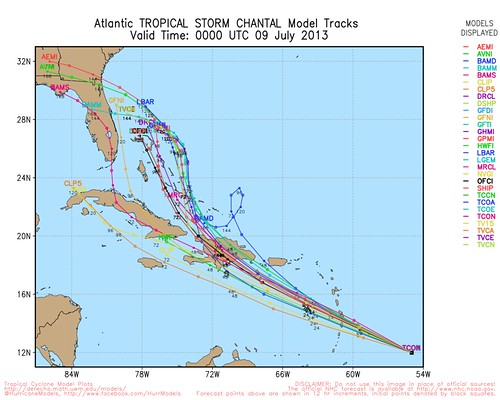
If, however, Chantal does manage to survive its passage over Hispaniola — something we won’t know until 48 to 72 hours from now — it looks reasonably likely to threaten somewhere in the southeast U.S. eventually, though the exact location, timing, and intensity are way too early to determine. The general pattern, though, appears reasonably clear from the computer models as of now: a northward turn, followed by a turn back to the west, toward the coast. Here’s a “spaghetti map” of various computer model tracks, via @HurricaneModels:
Tropical Tidbits explains the scenario:
In 72-96 hours, a longwave trough will dig into the eastern U.S. and help turn Chantal more towards the north, possibly clearing the Bahamas. In 96-120 hours, all of the models agree that a trough-split will occur, with the base of the longwave trough splitting away over the north gulf coast, allowing ridging to build back in to the northeast of Chantal. This is likely to force the storm back towards the southeastern U.S. coastline near the end of the forecast period. Exactly where this turn occurs will largely depend on the timing of the arrival of both the longwave trough and Chantal herself, and uncertainty is large at this time frame. However, a turn towards the SE US appears likely.
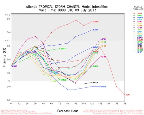
Moreover, Chantal could potentially re-intensify if she reaches the Bahamas & environs relatively intact, as conditions are expected to become more favorable for development on Thursday and Friday. Bastardi writes that “if this survives Caribbean (not favorable for July development) & Hispaniola, then [it will be in a] more favorable area [from] Bahamas to SE coast.” How favorable? Well, the intensity models (which are, I must caution, notoriously unreliable, far moreso than track models) aren’t predicting anything too extreme, though a few models do expect Chantal to become a weak hurricane within 5 days:
Again quoting Tropical Tidbits:
[A]s the trough-split occurs over the SE US [in 96-120 hours], the resulting upper low over the north gulf coast will begin backing westward away from Chantal, placing the storm in a region of light upper winds in between the aforementioned upper low to the west and another one to the east. This would be a favorable outflow pattern, and Chantal is expected to restrengthen during this time as it makes a turn towards the SE US coast. Exactly how much strengthening occurs is an uncertain question, as this is still about 5 days away, and the setup then may not be exactly as it is forecasted to be now. Regardless, the Bahamas and SE US should closely monitor Chantal’s progress.
Chantal is nothing to fear, or to hype, at this point. There’s no reason yet to cancel any weekend travel plans to Florida, Savannah or Charleston. Just keep an eye on it. I will be. (Follow me at @brendanloy for more frequent updates.)


Join the conversation as a VIP Member