Okay, so “nothingburger” isn’t the technical meteorological term. But Tropical Storm Chantal was downgraded, at 5:00 PM Eastern Time Wednesday, to a mere tropical wave — a disorganized mass of thunderstorms with no closed circulation. There will be no further advisories by the National Hurricane Center unless the storm makes a comeback. Over on Tropical Tidbits, weatherblogger Levi Cowan has a helpful video summary of what happened:
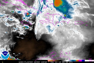
Here’s what Chantal’s remnants look like as of the wee hours Thursday morning:
Could redevelopment occur once Chantal’s remnants get a bit further west, and counter a more favorable environment? Perhaps. Joe Bastardi thinks so:
Map issued http://t.co/iyB2JWoY7i this morning showing what was shown yesterday…still a chance of comeback. pic.twitter.com/mhCyV9NpJb
— Joe Bastardi (@BigJoeBastardi) July 11, 2013
And so does the Canadian computer model:
Canadian global 00z wants to bring Chantal back as a weak TD or TS into S. Carolina on Saturday pic.twitter.com/Dzdyj47Prl
— Ryan Maue (@RyanMaue) July 11, 2013
But for now, that’s fairly speculative. We’ll just have to watch and wait.
This will be my last Weather Nerd update on Chantal unless conditions dictate otherwise — e.g., if restrengthening occurs or begins to look likely. Please follow me on Twitter (@brendanloy) for any updates in the meantime.


Join the conversation as a VIP Member