

That potential follow-up coastal storm that I mentioned on Friday — not a tropical system, and nowhere near as intense as Hurricane Sandy, but still a quite strong and colossally ill-timed Nor’easter — is looking more and more like a significant threat for later this week in some of the same areas hit hardest by Sandy. With each successive set of computer model runs, the storm looks stronger, and the likelihood of a hard coastal hit greater. Check out the latest European model, courtesy Ryan Maue:
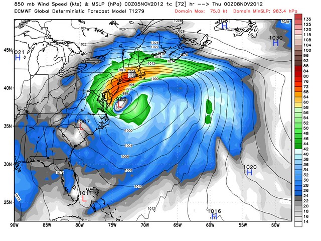
That’s the model’s forecast for Wednesday evening. Some models bring its strongest impacts ashore 12 hours earlier, Wednesday morning. (Mercifully, it appears that the storm will not move fast enough to seriously disrupt the election Tuesday.) Those orange and red zones on the map represent hurricane-force winds in the upper atmosphere. Down at the surface, the wind speeds won’t get that high — but we could potentially be looking at winds as high as 25-50+ mph along the coast, maybe with higher gusts. It depends on the exact track and intensity. (Some models now expect the system to “bomb out” and have its barometric pressure drop into the 970mb range, maybe even the high 960s. Certainly the low-to-mid 980s seems like a safe bet. The lower the pressure goes, the higher the winds can potentially get.)
And yes, there is a coastal flooding threat in New Jersey:
AccuWeather.com Meteorologists are concerned that a storm system riding up the East Coast could lead to a devastating water rise along the New Jersey coast on Tuesday Night into Wednesday. … [thanks] to a prolonged period of northeasterly, onshore winds for the New Jersey coastline.
A couple of things to keep in mind when it comes to this event. Had Hurricane Sandy not occurred earlier this week, we would be talking about a typical nor’easter with minor coastal flooding and a minor rise in water.
But, because of the destruction and erosion to the New Jersey coast that occurred, AccuWeather.com Expert Senior Meteorologist Bernie Rayno is concerned this could be a moderate to severe coastal flooding event.
The concern comes because of the fact that the protective dunes along the coast were basically wiped out from Atlantic City, N.J. on northward. This in turn, allows for any water rise to have free reign to flow into coastal communities with no barriers.
Though we aren’t at a time of astronomical high tide due to the phase of the moon, a more typical high tide is expected along the New Jersey coast after midnight Tuesday night and again Wednesday afternoon. And that could be the time when coastal flooding is at its worst.
Right now, if the track holds and the storm rides up the Eastern Seaboard and into southern New England, residents along the New Jersey coast can expect a water rise of 2-4 feet, which is on top of the normal tide cycles.
That means during high tide, Wednesday afternoon, water levels could reach upwards of 8-9 feet. While not as severe as during Hurricane Sandy, a rise like this could once again flood coastal communities with no dunes to protect it.
New York City should be in better shape because of the wind direction, which won’t pile water into New York Harbor the way Sandy did. That said, the rough weather will add insult to injury, particularly in Staten Island. Meanwhile, along the northern coast of Long Island and southern Connecticut, “minor coastal flooding” is possible. But the big coastal flooding concern will be for Sandy-devastated New Jersey.
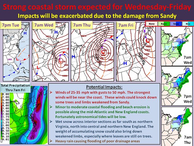
Here is a National Weather Service graphic summarizing the storm’s potential impacts:
The Weather Channel — which may name the system “Winter Storm Athena,” although they haven’t done so yet — adds:
If the low tracks close to the coast as our current forecast maps show, we will be dealing with a very windy, rainy and cold Wednesday into Thursday along the Northeast I-95 corridor. The strength and duration of the winds would be dictated by the exact track and strength of the low. The winds will kick up high surf along the coast that could lead to additional coastal flooding.
Across the interior Northeast or New England, there may be enough cold air for snow to go along with the windy conditions, particularly from the Poconos to the Catskills, Upstate New York and interior New England.
The snow zone could move further east, perhaps even impacting the major coastal cities, if the storm’s center is a bit further offshore, as some models suggest. On the bright side, that could lessen the wind/surge threat a bit, though regardless, this isn’t going to be pleasant for folks in its path, particularly those without power and whatnot.
Dr. Jeff Masters notes:
The storm is still four days away, and four-day forecasts of the path and intensity of Nor’easters usually have large errors. Nevertheless, residents and relief workers in the region hit by Sandy should anticipate the possibility of the arrival on Wednesday of a moderate-strength Nor’easter with heavy rain, accompanied by high winds capable of driving a 1-2 foot storm surge with battering waves. The surge and waves will potentially cause moderate to severe erosion on New Jersey coast, where Hurricane Sandy pulverized the protective beach dunes.
Joe Bastardi, on the premium WeatherBell site, calls the nor’easter a monster in its own right:
The Saga of Sandy continues as we are left with an exposed population in coastal areas with a powerful storm in its own right coming. Let me be clear, this is not tropical but will develop a warm core within the cold pool it’s embedded in … The development of the warm core in a colder pool means that there will be an area of high winds focused fairly close to the center with an eye-like structure likely off the mid atlantic coast by Wednesday night and Thursday morning. This is important since it means not only will there be fetch induced water backup but even a bit of the process that produces a “surge”…higher winds closer to the center rather than well removed.
Connecticut meteorologist Geoff Fox points out:
Unlike Hurricane Sandy there’s nothing really unusual about this storm. Weather patterns have begun their shift toward winter. This is a type of storm New England and the Northeast get often.
It just seems unfair it’s coming now!
Indeed.


Join the conversation as a VIP Member