

The National Hurricane Center did shift the official forecast track for Tropical Storm Fay a bit back to the right at 11:00 PM EDT, reflecting the computer model shift that I mentioned earlier. The official track “line” is now, for the moment, basically the worst-case scenario for Tampa.
Of course, the intensity forecast — 80 mph at landfall — is certainly not “worst-case.” But, as Dr. Jeff Masters points out in a detailed post about Tampa Bay storm surge potential, even a Cat. 1 storm could cause significant flooding if it were to follow this sort of track. Also, it’s not inconceivable that Fay could get stronger than currently forecast. Then again, it’s also quite possible she could be weaker. We just don’t know.
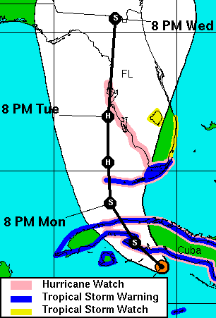
Nor do we know where she’ll go. Tampa’s current centrality on the forecast track map is almost meaningless; the track will probably continue to ping-pong this way and that over the next 48 hours, given the uncertainty and inconsistency in the computer models. (“THERE HAVE OBVIOUSLY BEEN SOME RUN-TO-RUN CONSISTENCY PROBLEMS WITH OUR TRACK GUIDANCE,” the 11pm discussion states in a candidate for Understatement Of The Year.) The “squiggly black line” has to point somewhere, and it presently points at Tampa, but that doesn’t make the Tampa scenario especially more likely than any other plausible scenario within the cone of probability.
Particularly with this storm, the NHC is right that “IT IS IMPORTANT NOT TO FOCUS ON THE EXACT FORECAST TRACK.” We really, really ought to be focusing instead on the “cone,” which still includes almost the entire west coast of Florida. Any of those places could still get hit. This is partly because of Fay’s unpredictable nature, and partly because of her expected angle of approach to the Florida coast. As the 5pm discussion stated:
THE FORECAST TRACK SITUATION IS SIMILAR TO THAT OF HURRICANE CHARLEY FROM AUGUST 2004…IN THAT A SMALL CHANGE IN THE TRACK OF THE STORM COULD MAKE A BIG DIFFERENCE IN THE EVENTUAL LANDFALL LOCATION. THE NHC WIND SPEED PROBABILITIES PRODUCT SHOWS ABOUT AN EQUAL CHANCE OF HURRICANE-FORCE WINDS FOR THE ENTIRE WEST COAST OF THE FLORIDA PENINSULA.
Anyway, here’s a look at the current track and cone, for what they’re worth:
The current NHC discussion contains this bit about the intensity forecast for Fay:
AN UPPER-LEVEL LOW OVER THE EXTREME NORTHWESTERN CARIBBEAN SEA IS IMPEDING THE OUTFLOW OVER THE WESTERN PORTION OF THE TROPICAL CYCLONE AND MAY EVEN BE CAUSING SOME UPPER-LEVEL CONVERGENCE OVER THE STORM. ON THE OTHER HAND…THE SHIPS GUIDANCE INDICATES THAT VERTICAL SHEAR WILL DECREASE DURING THE NEXT DAY OR SO. THEREFORE SOME STRENGTHENING IS FORECAST WHILE FAY IS OVER WATER [NORTH OF CUBA] DURING THE EARLIER PART OF THE FORECAST PERIOD. BY 48 HOURS OR SO…SHEAR ASSOCIATED WITH AN UPPER-LEVEL TROUGH OVER THE EXTREME EASTERN GULF OF MEXICO IS FORECAST TO INCREASE…AND THIS SHOULD LIMIT INTENSIFICATION. THE OFFICIAL INTENSITY FORECAST IS A BLEND OF THE LATEST GFDL AND HWRF MODEL PREDICTIONS. IT SHOULD BE ADDED THAT THERE IS LOW CONFIDENCE IN THIS FORECAST HOWEVER.
I know I sound like a broken record, but the bottom line is that, 48 hours or less from landfall in Florida, forecasters just don’t know what Fay is going to do.
P.S. Alan Sullivan writes: “it should be emphasized that Fay is disorganized, sheered, and approaching land. It is not likely to reach hurricane strength at all on this course, though it will undoubtedly intensify some when it crosses the Florida Straits tomorrow.” But Sullivan is guessing that Fay will take a sharper right turn than currently forecast. The further north it goes, the more likely it is to intensify — though wind shear will also increasingly become a factor, so rapid intensification (a la Charley) seems unlikely in any event.


Join the conversation as a VIP Member