

After toying with forecasters for days, Invest 92L has finally become Tropical Storm Fay — skipping right over T.D. status — as of 5pm EDT.
I’m busy now, but I’ll post a full update later tonight. (Posted via cell phone.)
UPDATE, 11:12 PM EDT: Fay was designated a tropical storm while its center was over land — “a highly unusual development,” as Alan Sullivan notes — and the storm has actually strengthened slightly, from 40 mph to 45 mph, during the center’s passage over the Dominican Republic.
That said, some weakening is likely in the next 12 hours or so, before the storm emerges over water again. Indeed, as the NHC’s 11pm EDT discussion puts it, “THE IMMEDIATE UNKNOWN IS HOW MUCH OF FAY WILL EMERGE OVER THE CARIBBEAN WATERS.” It remains possible the mountains of Hispaniola will tear the circulation apart. But the NHC doubts it. More likely, the storm will emerge intact, though weak, tomorrow morning. And then things will get really interesting.
First, a caveat: There’s even more uncertainty than usual in forecasting Fay’s track and intensity because, as Dr. Jeff Masters points out, “the high mountains of both Hispaniola and Cuba…may force sudden jumps in the center position as the storm reforms closer to its heaviest thunderstorm activity.” If this happens, and the “jumps” are dramatic enough, it could totally change the forecast logic.
That said, at present, Fay is looking more and more like a threat to the Gulf of Mexico coast. The computer models forecasting her track have shifted dramatically — and almost unanimously — to the left, or west, during the course of the day today. Check out the Colorado State University “spaghetti” plots as of 2:00 AM, 8:00 AM, 2:00 PM, and 8:00 PM EDT today:
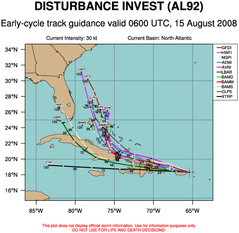


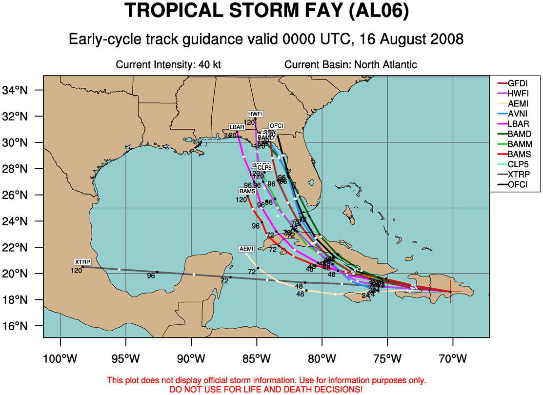
As you can see, whereas the consensus this morning was that Fay would probably stay east of Florida, it has shifted this evening to the point where Fay now looks more likely to stay west of the Florida peninsula, and instead threaten the Gulf coast early next week.
The NHC’s official forecast track (which has got to look awfully scary to folks in Tampa) has not fully shifted westward to reflect this changing guidance. As forecaster Lexicon Avila explained in the 11pm EDT discussion, “MOST OF THE GUIDANCE HAS SHIFTED WESTWARD AND THE OFFICIAL FORECAST IS ON THE EASTERN EDGE OF THE ENVELOPE. [BUT] BEFORE I AM COMMITTED TO SHIFT THE TRACK FARTHER WEST…I WOULD RATHER WAIT TO SEE IF GUIDANCE BECOMES MORE STABLE FROM ONE RUN TO THE NEXT.” Translation: if the computer models continue predicting what they’re predicting now, the NHC’s forecast will soon follow suit.
The more immediate impact of this leftward shift in the model forecast guidance is its possible impact on land interaction inhibiting the storm’s development — or the lack of such interaction and inhibition, as the case may be. In short, the odds of Fay becoming a major hurricane have increased substantially just since this afternoon.
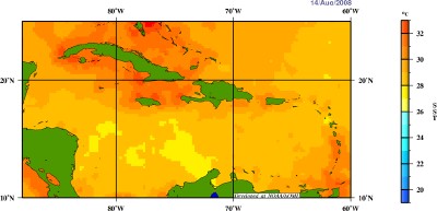
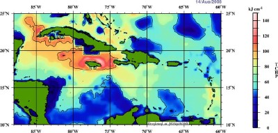
The models have gone from believing this morning that Fay would stay mostly north of Cuba (and thus have lots of warm water to work with), to believing this afternoon that Fay would basically rake the entire island of Cuba (and thus have less time to strengthen over water), to believing this evening that Fay would stay mostly south of Cuba (and thus, again, have lots of warm water to work with). This is particularly alarming given the Sea Surface Temperatures and Tropical Cyclone Heat Potential of those waters:
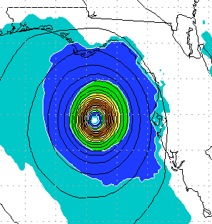
Some of the computer models predict explosive development once Fay exits Cuba. The HWRF, for instance, shows a Category 3-4 hurricane approaching the Florida panhandle on Wednesday:
But Dr. Jeff Masters — writing shortly after 5pm EDT, before the latest model runs — expresses skepticism. Masters remainds us of 2006’s overhyped Ernesto, which the computer models expected to intensify rapidly after it emerged from Cuba as a weak tropical storm, but which instead “took a full 36 hours to get its act together.” Will Fay behave similarly? Perhaps. But it’s certainly possible, given the water temperatures and the atmospheric conditions and the model forecast tracks, that she’ll blow up into something more serious, more quickly.
The official forecast calls for Fay to reach a maximum intensity of 85 mph, but that could be a low estimate, depending on the exact track. It’s quite possible Fay could end up a major hurricane in the Gulf, if she avoids excessive interaction with Cuba’s mountains and stays over open water long enough. Avila notes that the official forecast is more “conservative” than some of the computer models, and he acknowledges the potential danger, writing:
IN SUMMARY…BOTH OFFICIAL FORECAST AND GUIDANCE SHOW AN INTENSIFYING TROPICAL CYCLONE MOVING ACROSS CENTRAL CUBA AND INTO THE EXTREME SOUTHEASTERN GULF OF MEXICO. WE MUST PAY VERY CLOSE ATTENTION TO THE EVOLUTION OF THIS TROPICAL CYCLONE.
Definitely stay tuned on this one. It may yet fizzle, but on the other hand, Fay could be the real deal. Folks in Florida and along the Gulf coast, stay tuned this weekend. Do not sleep on this storm. Again, it may turn out to be nothing, but for now, you definitely want to keep an eye on the forecast.


Join the conversation as a VIP Member