

The Washington Post‘s Capital Weather Gang has an excellent summary of the forecast situation with Hurricane Sandy. Money quote:
There is a consensus forming in weather forecast models that hurricane Sandy is unlikely to go out to sea. Instead, it more likely will merge with a strong fall cold front and transition into a powerhouse, possibly historic mid-latitude storm along the mid-Atlantic and/or Northeast coast Sunday through Wednesday.
I’d quote more of the post, but the whole thing is really informative, so I’d just advise you to go read it.
Also worth reading: the National Hurricane Center’s 5pm EDT discussion, which confirms that the trend has shifted west, while also rightly emphasizing that a huge amount of doubt remains about what Sandy will do: “THE UNCERTAINTY IN THE LONG-RANGE TRACK FORECAST REMAINS VERY HIGH…AND IT IS TOO EARLY TO DETERMINE SPECIFIC IMPACTS FOR THE U.S. EAST COAST NORTH OF FLORIDA.”
Having said that, here’s the latest Euro model forecast for Monday morning, via Joe Bastardi:
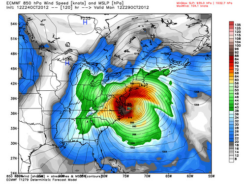
The exact forecast will vary from model run to model run, so don’t obsess over the details. As Geoff Fox says, “It is still too early to think its post-weekend location can be accurately forecast.” The point is that various scenarios are in play whereby Sandy would potentially be a major, major weather event. So, stay tuned.
(Again, for more frequent updates, follow me on Twitter.)


Join the conversation as a VIP Member