

[NOTE: check the blog homepage and follow me on Twitter for the very latest.]
* * * * *
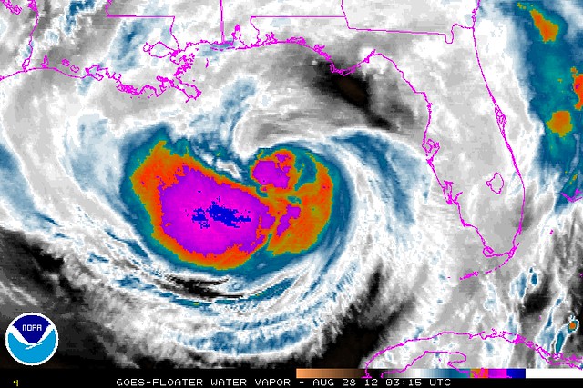
For the third consecutive advisory, the belief that Isaac might imminently become a hurricane was not vindicated at 11:00 PM EDT, as the storm’s winds were held at 70 mph, just shy of hurricane strength — even as the pressure dropped to 979 millibars, which is usually more typical of a borderline Category 1/Category 2 hurricane.
In this sense, Isaac is reminiscent of a poor man’s Hurricane Ike, which at one point had a pressure of 944 mb, typical of a borderline Category 3/Category 4 hurricane, yet its winds refused to budge from 100 mph (borderline Category 1/Category 2). People kept insisting that Ike’s winds would inevitably “catch up” to the pressure, in a burst of rapid strengthening that was always just around the corner. There was also fear that the pressure, plus the storm’s immense size, would lead to an epic storm surge well out of proportion to the winds and category. Similar fears are being expressed with Isaac. Yet Ike’s winds never did “catch up” with its pressure, and the surge underwhelmed — it was a hive, not a pimple.
Likewise, another “I” storm — last year’s Hurricane Irene — at one point had a pressure of 942 mb, typical of a Category 4, but winds of 110 mph that never “caught up” with the pressure. Indeed, Irene eventually weakened to a minimal hurricane, 75 mph, with a pressure of 958 mb (typical of a mid-range Category 3), and then to a tropical storm, 60 mph, with a pressure of 966 mb (typical of a high-end Category 2). Irene, too, produced fears of a storm surge vastly out-of-proportion to its wind and category — yet the reality again underwhelmed.
I’m not saying that Isaac is Ike redux or Irene redux — every storm is different — and I certainly think folks in surge-prone areas should prepare for the worst (or, more precisely, should already have prepared for the worst), including by evacuating if appropriate. But the parallels do give me some pause about the current storm-surge predictions. We shall see.
Meanwhile, I still suspect Isaac will become a hurricane overnight — but I can’t help but wonder, what if my Thursday-morning post, “Might Isaac Never Become A Hurricane?,” turns out to be accurate? I had given up on the notion days ago, but with less than 24 hours until landfall, the storm is running out of time!
In any case, it makes little difference — a 70 mph tropical storm and a 75 mph hurricane are basically the same thing. The question isn’t whether Isaac will become a minimal hurricane, but whether it will have the type of overnight/morning rapid intensification phase, just before landfall, foreseen by the GFS earlier today. It still may. And intensification at landfall would make the storm feel like much more of a beast, as I explained earlier. But every time you think this storm is about to go “rapid,” dry air keeps interfering. That’s very good news for New Orleans & environs, and although I feel a certain dread about the inevitable cries of “OVERHYPE!!!1!” if that good luck continues, it’s obviously best for everyone if it does.
I’ll try to post an update in the morning sometime around 8:00 AM Eastern. Maybe Isaac will finally be a hurricane by then. Stay tuned, as they say.
P.S. One final note. Up until now, talk of various worst-case scenarios, or at least of very-bad scenarios, has been justified and proper, because of the forecast uncertainty and the very real possibilities of calamity that existed. Several people have asserted to me that there was “no evidence” Isaac would become a major hurricane, but that’s just categorically false: multiple reliable computer models had multiple consecutive runs showing a Category 3 or stronger hurricane making landfall on the Gulf coast. Those models weren’t invented by TV pundits or weatherbloggers. They were real, and they were scary. Moreover, although this storm has proven to lack intensity, it’s taking a horrific track from NOLA’s perspective, and if it weren’t for several very persistent dry-air entrainments — something that just can’t be predicted with any degree of certainty — we really could be looking an extremely dire situation right now. This was a close-run thing. The large-scale conditions for strengthening to a major hurricane (good outflow, low shear, warm waters) were nearly perfect; only hard-to-predict small-scale features (dry air, core structure) prevented Isaac from reaching its potential. Meteorologically speaking, particularly in light of the track, this was closer to a disaster than the overhype-troll crowd will ever understand.
However.
Barring significant overnight intensification, the media must dial back the “hype” in the morning. Unless we all wake up to an exploding Isaac that’s finally worked out its dry-air and inner-core issues and is seriously ramping up just before landfall, the worst-case scenarios in terms of intensity will no longer be valid or relevant. So it’ll be time to stop talking about them, and indeed, to explicitly acknowledge that they’re now off the table. Yes, there will still be a significant (though, let’s not kid ourselves, probably not catastrophic) storm surge, plus major threats in terms of inland flooding (that one COULD be catastrophic) and perhaps inland winds, power outages, etc., etc. But those concerns are of a different order from the apocalyptic fears many of us justly felt when we saw model maps like this. It insults readers’ and viewers’ intelligence to treat “ordinary” storm impacts, like typical coastal flooding, downed trees, widespread power outages, gas station roofs blowing in the wind, etc., as epic events of grave significance on par with the sort of impacts we originally feared. This is where media gets hurricanes wrong: not by discussing worst-case scenarios early on, when they’re still plausible and in fact the public needs to be aware of them, but by failing to back off the “hype” once it’s clear that the worst isn’t happening. There’s a reason you’ve seen this blog steadily backing off the worst-case talk today: I always try my best to “keep it real,” and call it like I see it — and it’s become increasingly clear to me that this storm, while very serious (all hurricanes, and near-hurricanes, are!), isn’t going to be an epic catastrophe, after all. It could have been, but now it’s very likely not going to be. I try to make sure my coverage reflects that once it becomes clear. I hope the MSM will do so too.


Join the conversation as a VIP Member