

[NOTE: For the very latest on Nate, check my Twitter feed.]
* * * * *
Sometimes, in the life of a tropical cyclone, there is a distinct turning point in the evolution of the track forecast, where the computer models suddenly shift toward a new and markedly different solution. When this happens, the National Hurricane Center — wanting to avoid a “ping-pong effect” of models shifting back and forth, as can happen during periods of forecast uncertainty — generally waits to see a few more model “runs” confirming the new thinking before it fully adopts the new consensus in its official forecast. This memorably happened in 2005 with Hurricane Katrina, when the models shifted early Friday morning toward a solution targeting the New Orleans area, inspiring my “New Orleans in peril” post at midday Friday (which I would later read aloud in Spike Lee’s movie), published eight hours before the NHC actually adopted the track that the models had begun shifting toward almost 24 hours before. More recently, something similar (albeit less drastic) happened with Hurricane Irene, when the models’ eastward trend suddenly stopped, and the forecast began to settle on a track targeting New Jersey/NYC/Long Island.
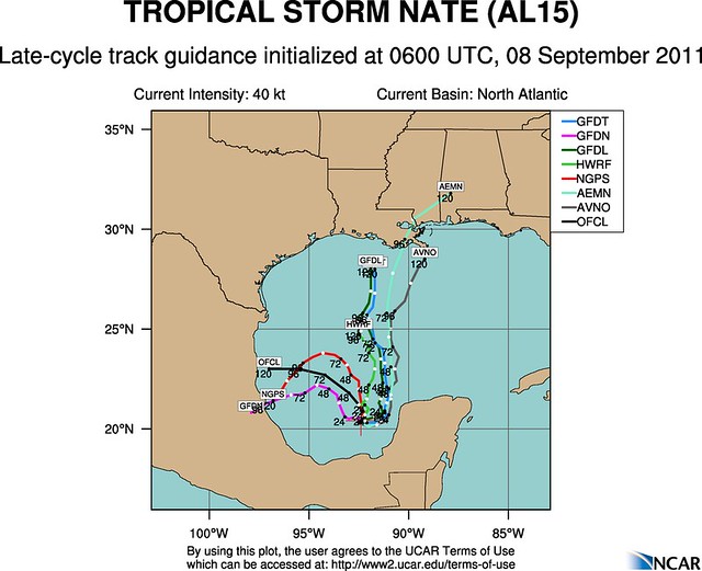
We may be seeing a similar turning point with Tropical Storm Nate this morning. Yesterday, this storm looked like it was bound for Mexico. But things have changed overnight. This morning, shortly before the National Hurricane Center’s 11am EDT advisory, Charles Fenwick tweeted: “In the Gulf of Mexico, there was a good consensus on Nate heading to Tampico, Mexico. This morning, though, GFDL & HWRF shifted northeast with solutions south of Louisiana and in the middle of the western Gulf of Mexico respectively.”
Dr. Jeff Masters summarizes:
Up until last night’s 8 pm EDT runs of the computer models, the models were in general agreement that Nate would meander in the Bay of Campeche for several days, until a ridge of high pressure built in to the north of the storm, forcing it westwards to a landfall in Mexico. However, the latest 2 am EDT run by the GFS model predicts that Nate may gain enough latitude to escape being forced westwards by the ridge, and instead move northwards to make a landfall along the U.S. Gulf Coast. The GFDL, which uses the GFS for its initial conditions, is also on board with this idea, as is the HWRF model, to a lesser degree. The 2 am EDT run of the NOGAPS model did not go along with this idea, though. We will have to wait until the NOAA jet makes its first mission to sample the steering currents in the Gulf of Mexico to get a better idea on how probable this northern path might be; their first flight will be tonight, and the data will make it into the 8 pm models runs that will be available first thing Friday morning.
The Houston Chronicle‘s Eric Berger, in a post titled “The northern Gulf of Mexico is back in play,” elaborates:
Just as it looked like the overnight models were converging on one solution for the track of Tropical Storm Nate, this morning’s models made an almost wholesale change.
Instead of an eventual westerly motion into Mexico, a number of forecast models have switched back to a more northerly movement by late this weekend, bringing Nate toward the northern Gulf of Mexico coast by late Sunday or Monday.
It will be most interesting to watch the newest global model runs, which should come out between noon and 2 p.m. today. I’ll especially be looking to see if the European model switches back to the more northerly solution. If you’ll recall, until yesterday this had been the Euro model’s preferred track. …
Critically, if Nate does move northward it will cross over very warm Gulf waters, and would have several days to intensify. This raises the possibility of a major hurricane striking the New Orleans region.
It still appears Texas will not be directly affected by strong winds and rain from Nate, but this is indeed proving to be a difficult storm to nail down.
Fenwick added: “NHC will probably wait for 12Z models before making any drastic changes to the forecasts, so 11AM forecast package shouldn’t have big track changes.”
The 11am discussion confirmed all of this:
AFTER 36-48 HOURS…THE MODEL SPREAD BECOMES INCREASINGLY LARGE…AS SUBTLE DIFFERENCES IN THE STRENGTH AND ORIENTATION OF A MID/UPPER-LEVEL LOW AND TROUGH EXTENDING FROM THE OHIO VALLEY SOUTHWESTWARD HAVE SIGNIFICANT IMPLICATIONS ON THE FUTURE TRACK OF THE CYCLONE. THE LATEST GFS AND GFDL MODELS…WHICH SHOW A SLIGHTLY DEEPER TROUGH…MOVE NATE NORTHWARD TOWARD THE NORTHERN GULF COAST. THE ECMWF AND NOGAPS MODELS DEPICT A WEAKER TROUGH THAT DOES NOT CAPTURE NATE AND ALLOWS IT TURN TURN WESTWARD TOWARD MEXICO TO THE SOUTH OF A BUILDING RIDGE…ALTHOUGH IT SHOULD BE NOTED THAT THERE IS CONSIDERABLE SPREAD AMONG THE ECMWF ENSEMBLE MEMBERS. THE OFFICIAL FORECAST HAS BEEN SHIFTED TO THE RIGHT AND LIES BETWEEN THESE TWO VIABLE SCENARIOS BUT HAS NOT BEEN SHIFTED AS FAR AS THE TVCA CONSENSUS. THE NOAA G-IV AIRCRAFT IS SCHEDULED TO PERFORM A SYNOPTIC SURVEILLANCE MISSION LATER TODAY…WHICH WILL HOPEFULLY HELP REDUCE THE SPREAD IN THE TRACK GUIDANCE TONIGHT.
Today would be a good day to follow my schedule and watch as the new computer models come out. Already, the latest GFS model run has seen the track details shift a bit, though the basic concept — a more northerly track, threatening the Gulf coast — remains. As Fenwick explains: “the 12Z GFS…has split the difference between its last 2 solutions & has Nate hanging out in the northwest Gulf of Mexico through day 7.” Here’s what the 7-day model forecast position looks like, with Nate on the left and Maria on the right:
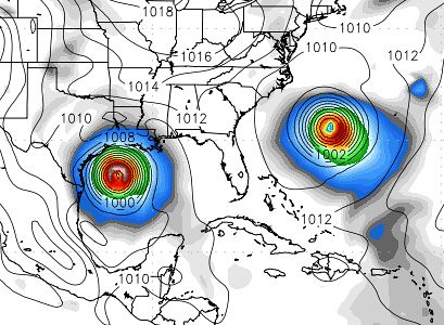
Maria, incidentally, appears likely to recurve harmlessly out to sea, much like Katia (though that could change). It’s Nate we need to be watching.
To be clear, there is no reason to panic about possible threats to specific locales. The forecast can and will change in the coming hours and days. But with the Gulf waters being so warm, and so many vulnerable spots along the coast, this is definitely a situation to watch closely.


Join the conversation as a VIP Member