

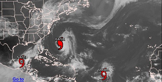
The Atlantic tropics have been busy since Irene’s demise 10 days ago, what with Hurricane Katia, Tropical Storm Lee, Tropical Storm Maria, and now, as of a few hours ago, Tropical Storm Nate.
Lee dumped copious rain in the Southeast, and now its remnants are causing further flooding in the already saturated Northeast. Katia, which at one point reached Category 4 intensity, threatened for a while to be Irene redux, but now the computer models are extremely confident it will “recurve” safely off to sea. Maria looks likely to remain weak for a while, but could eventually strengthen and become a threat to the East Coast — but it’s way too early to tell, and any possible impact would occur no earlier than mid to late next week.
Nate, however, could become a big deal, and fast. The Hurricane Center named the storm, presently located in the Bay of Campeche / southern Gulf of Mexico, at 5pm EDT today, estimating its winds “conservatively” at 45 mph — and there are signs its intensity could ramp up quickly. Florida State meteorologist Ryan Maue, whose Twitter feed and website are excellent sources for computer model information, tweeted this afternoon, “With the curved cloud band of Nate–I’d expect explosive intensification. Wouldn’t be surprised to see hurricane in < 24 hours. Major < 72?" The waters of the Gulf of Mexico, of course, are very warm with a lot of cyclone heat potential, and there’s virtually no wind shear nearby to weaken Nate. So — with the caveat that, as Irene reminded us, intensity forecasting is a very inexact science — conditions certainly look ripe for significant and perhaps rapid strengthening.
Nate’s location is the other reason for concern. It could potentially pose a threat to anywhere from the Mexican east coast to Florida. The computer models just aren’t sure yet, and the steering currents are weak. A slow track toward Mexico presently seems the most likely, as the official forecast indicates:
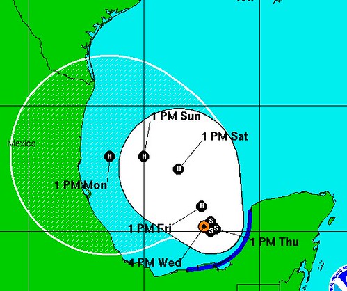
In light of the generally sparse population along much of the Mexican coastline, that’s preferable to some previous computer model scenarios like a direct, quick strike on New Orleans, a Florida panhandle landfall, or a Mobile hurricane. But, again, it’s just too soon to tell for sure what will happen. Hopefully the models will get a better handle on Nate within the next 24 hours, now that it’s gone from being a hypothetical storm to an actual existing one.
Another big question is what impact Nate might have on the disastrous Texas wildfires. The recent blazes were actually fanned by the winds of Tropical Storm Lee and the cold front that swept in behind it — a cold front whose southern portion then stalled over the Gulf, developed tropical characteristics, and turned into…Tropical Storm Nate. So could Nate, partially a product of the weather system that helped fuel the fires, now help put them out, by bringing tropical rains to Texas?
Unfortunately, that isn’t likely, says Dr. Jeff Masters: “None of the models is hinting at a track towards Texas, and the intense dome of high pressure associated with their record drought and heat wave will tend to discourage any tropical cyclones from making a Texas landfall over the coming seven days.” The Houston Chronicle‘s “SciGuy,” Eric Berger, agrees: “It does appear likely Texas, due to building high pressure over the state, will not see significant rainfall from Nate, especially areas outside of lower Texas.”
Speaking only for myself here, it seems like what Texas might actually need to “root” for is Nate becoming a fairly powerful hurricane — powerful enough to “make its own atmosphere,” and maybe, just maybe, push back a bit against that intense high-pressure dome. But of course, that’s a catch-22. What Texas needs is a tropical storm with soaking rains, not a disastrous major hurricane.
Wherever Nate goes, its formation is historic, or nearly so. Nate is the second-earliest forming “N” storm ever, trailing only the “N” storm of the record-shattering 2005 season — coincidentally also named “Nate,” thanks to the six-year rotating storm name list — which formed just one day earlier. The 2011 season hasn’t seen nearly as many intense hurricanes as we saw in 2005, nor as many devastating landfalling hurricanes. But in terms of sheer numbers, it’s keeping pace thus far, which is amazing. The 2005 season, you may recall, was the first ever to exhaust all 21 listed names (Q, U, X, Y and Z are skipped) and send us into the Greek alphabet, with the season’s final storm, “Zeta” (the sixth Greek letter, and 27th named storm), memorably forming on my wedding day, December 30, and not dying until January 6 of the following year (during my honeymoon). And it turns out there was actually another storm, making the total 28 — Zeta should have been Eta.
Anyway, the point is, we’re presently on 2005’s pace, or within a day of it, which is incredible; I never thought I’d see another season approaching 2005. Who knows if it will continue — probably not. But 2011 is certainly turning out to me one heck of a year. And “Ophelia” may be coming soon to a hurricane tracking map near you.
I’ll try to post an update on Nate (and the other storms) later tonight and/or tomorrow morning. In the mean time, you can get the latest — mixed in with a lot of nonsense about college football, conference realignment, tonight’s GOP presidential debate, and so forth — from my Twitter feed.


Join the conversation as a VIP Member