The trend is your friend: Irene track shifts east, again
Quick late update here. The Weather Channel’s Jim Cantore says he had a pit in his stomach when he saw this computer-model forecast from the GFS earlier today:
But now the late-night 0Z GFS computer model is out, and — guess what? — it shifts Irene’s landfall point to the east, again. Now the target landfall location has moved from NYC/Long Island to Cape Cod:
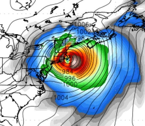
Actually, isn’t Martha’s Vineyard in the eye there? Is Mother Nature trying to tell President Obama something? Heh!
In all seriousness, again, the point isn’t the exact landfall point, which is subject to huge errors this far out. The point is the trend. The trend is your friend. And the rightward trend is continuing.
This hurricane may yet stay out to sea, folks. Cross your fingers.
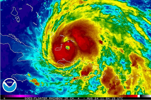
On a less reassuring note, Irene looks on satellite like she’s really getting her act together. Also, the barometric pressure has been dropping this evening. The winds often take time to “catch up” with the pressure, and that delay has been happening. But the winds will catch up very soon. I expect to wake up in the morning to a significantly strengthened storm, and I wouldn’t be surprised if it’s rapidly intensifying.


A hurricane in Marthas Vineyard? Proof that mother nature is racist!
In all seriousness, again, the point isn’t the exact landfall point, which is subject to huge errors this far out. The point is the trend. The trend is your friend. And the rightward trend is continuing.
This confuses me. It seems to say that the best estimate of the track of the storm is not the current projection, but, because the last few projections have trended east, the best estimate now is somewhere east of the current projection. But… if trend works like that, wouldnt the models take such trend into account already? Making the current projection itself the best estimate? (Sort of an Efficient Market Hypothesis kind of thingie.)
Fair question, Pseudolus. The “trend is your friend” concept is admittedly unscientific, or at least, not totally scientific. And the National Hurricane Center certainly doesn’t subscribe to it. They base their forecasts primarily on the latest computer model consensus, with a bias, if anything, toward looking back at the PREVIOUS model consensus (because they’re conservative in their forecasting; they don’t like to vacillate wildly back and forth between forecast tracks, in the event of the models ping-ponging between solutions, as sometimes happens), not at looking forward toward an anticipated FUTURE model consensus.
But we armchair storm-watchers (and plenty of actual meteorologists, too) see the “trend is your friend” scenario play out over and over again, particularly with recurving storms. We’ve seen it frequently enough that do we put some stock in it, while certainly not ignoring the present forecasts. To understand why, let me make an analogy to polling, which PajamasMedia/InstaPundit’s politically minded readership probably has more familiarity with than meteorological computer models.
Think of each individual model run as analogous to an individual poll during the presidential election season, and a model (which does multiple “runs” per day) as analogous to a pollster (which takes multiple polls). Some models are more reliable than others — AVN or the European model are sort of like Gallup, while another model, lets say NOGAPS, might be more like Zogby. (I’m picking on NOGAPS arbitrarily; I’m not sure which models are considered the worst.) Also, some individual model runs — like individual polls by a particular pollster — may be outliers: just as you might get a wonky Gallup poll showing a 5-point deviation from the Gallup polls before & after, you might get an anomalous GFS run here and there (which is why the NHC is conservative about immediately shifting its forecasts when the models shift).
The NHC’s forecast is sort of like a Nate Silver analysis of the polls on FiveThirtyEight. It takes all the various models, including models of models that synthesize the other models together to come up with a consensus (like the Pollster.com or RealClearPolitics polls of polls, or FiveThirtyEight’s regression analysis), and then it sprinkles in some subjective/qualitative analysis, maybe even a little bit of gut feeling, and comes up with a forecast that’s loosely based on — but not slavishly duplicative of — the underlying models.
Where does the “trend is your friend” concept fit in? Well, suppose you’re a political pundit, or just an astute blogger, and you’re looking at the same poll data that Nate Silver and his model are looking at, but you think you’re noticing something he isn’t adequately calling attention to: that, hypothetically, Obama’s lead over Perry has been steadily shrinking in the Gallup poll and others, from 8 points to 6 points to 3 points to 1 point. You look at this and think, gee, that trend could indicate some underlying pattern, and if the trend is likely to continue, then Perry should really be considered the favorite at this point, even though Obama is nominally still ahead.
However, if you’re just looking at the latest snapshot polls (like the current model runs), Obama’s up by 1. FiveThirtyEight’s regression analysis, meanwhile (like an NHC forecast), probably has Obama up 2 or 3, because the prior polls have a lingering impact on the analysis, and hypothetical future polls aren’t factored in at all. Yet those hypothetical future polls weigh heavily on *your* mind, because you’re looking at it from a more “gut” or “common sense” perspective, and trends that drastic are often a sign of things to come.
So… who’s right in this hypothetical analogous scenario? Is Obama up 2 or 3 points, or is he up 1, or is the “trend your friend” and Perry’s really the favorite? Certainly, trends can and sometimes do reverse. But they often don’t. I can’t back this up with mathematical proof, but it’s my anecdotal observation that, with storms of this type/track, when the trend is *this pronounced*, it more often than not continues, and rarely outright reverses. That’s no guarantee, of course — far from it — but then, neither is any individual model run or NHC forecast a guarantee. So, in my mind, the “trend” is something to weigh along with the other data: you don’t assume its right, but you also don’t just ignore it. Thus, just as you might think Perry is the favorite in the scenario I’ve described because the “trend” is so pronounced — even though he’s nominally still behind — likewise I view further eastward shifting as a slight favorite right now.
That said, all it takes is one or two polls showing Obama suddenly up 5 again to totally change the picture… and that’s why the forthcoming runs of the AVN and Euro models, due out in the next few hours, are so critical. If the eastward trend stops or reverses, then we have a whole new situation.
Does that make sense?
Brendan – Thanks for the informative response.
I guess what my mind wants to think about is the underlying nature of the data exhibiting a trend, and whether that kind of data might be expected to have some kind of momentum property. Does a shift of voters in one direction portend further shifts in the same direction? Possibly. Plausibly, at least. But since these models are designed by smart folks who, one would think and hope, would be inclined to use all the best information at their disposal, including (if it would actually help), the trend of the last few iterations of their model, I wouldnt expect those kinds of numbers to have momentum.
Now, I dont know anything about the specifics of these models and I only even see the results of them a couple times a year when big storms are abrewin, so I dont put a lot of weight on that expectation of mine. But its fun to think about.
Thanks again.
Thanks for the excellent question! I just put this discussion in a new post because I think it’s very worthwhile.
I’m not sure I’m qualified to answer your question about the nature of the data, since after all, I’m just a layman, not a meteorologist. To me, the computer models are just pretty maps; I have no knowledge of the underlying math. However, I know they basically model the entire atmosphere based on observed data (interpreted by equations), and I imagine it might be difficult to insert trends in specific storms’ paths into those equations, since the models aren’t just predicting particular storms’ paths, they’re predicting the entire atmosphere. That said, presumably as the models get better and better (which they do constantly, with ongoing research and development, not to mention the creation of new and better models), the “trend” would become less important, because each individual model run would become more accurate, and whatever underlying atmospheric forces are driving the “trend” would be better incorporated into the model from the get-go.
Im not much of storm geek, even as a layman, but I also use the trend as a rule of thumb. The general phenomenon, as Ive observed, is that a forecast which is wrong (as most are) is likely to continue being wrong in the same manner as it was. This is precisely *because* meteorologists are biased in favor of previous models. They dont like to give wildly varying forecasts, even though if the data offers a varying outcome.
You can observe this especially with the eternal question: rain or snow? (Unless you live in Northernmost states or Canada, where I assume this is rare.) Snow is forecast, then snow/sleet, then sleet or freezing rain. You can expect – without scientific basis, of course – that once the forecast starts to move in that direction (where the meteorologists are increasingly unsure that the temperature is going to stay below freezing), its going to end up mostly rain.
I am trying to go to the phillies game on Sunday. Do you think it will be rained out?
Trends are nice, but Ill take a three-day-long sub-zero blizzard over one of these hurricanes any day. This type of storm is why I left the East Coast many years ago and returned to the mountains of Colorado. Havent regretted it either, even when we have weekly two-foot snowfalls.
I do enjoy your reporting. Thanks to Instapundit for pointing me towards your site. Keep up the good work.
Brendan, your #5 above is an excellent summary. I also am not a meteorologist, but I have an up-close-and-personal interest as both a seaman and an East Coast resident.
It’s my understanding that previous model errors are not part of the initial conditions for future model runs; if I get confirmation of that I’ll let you know.
NWS meteorologists do “forecast verification”: looking at how current conditions differ from model predictions and previous forecasts. Deciding how best to use that knowledge in the next forecast is part of the “art” in forecasting.