

[UPDATE, 3:24 PM Pacific: I’ve just posted a new update incorporating the NHC’s 5pm EDT advisory. It looks like the below post may have been a wee bit too sanguine about the possible New York/New Jersey threat, though there’s still no cause for panic. But really, just read the whole thing]
The 2011 hurricane season, like the 2010 season before it, has been quite active in terms of how many named storms it has produced: nine and counting through mid-August, with the peak of the season still a couple of weeks away. But up until now, not a single storm had become a hurricane, let alone a major hurricane. Hurricane Irene is changing all that.
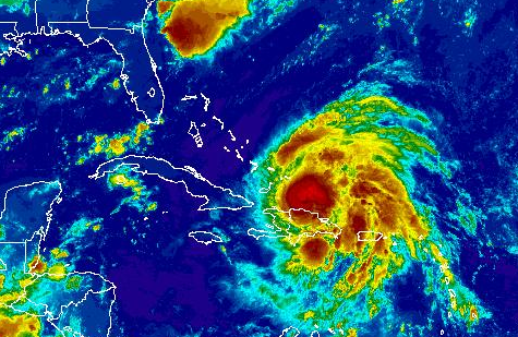
After a burst of sudden intensification yesterday, Irene is now a Category 2 hurricane, and is expected to strengthen as it moves into the Bahamas and menaces the East Coast. But how strong will she get, and where will she go?
Meteorologists have extremely limited skill at predicting hurricane intensity. They can say whether the meta-conditions are broadly favorable or unfavorable for intensification, but the computer models simply do not know how to take into account many of the smaller variables that can have tremendous impact on storm strength. So it’s not very productive, at this point, to speculate on whether Irene will peak as a low-end Category 3, a high-end Category 3, a low-end Category 4, or worse. Forecasters suspect she’ll soon become a major hurricane (Cat. 3 or higher), and will stay “major” for some period of time, but beyond that, nobody really knows. Suffice it to say, this storm is likely to approach the coast as an intense, and geographically large, hurricane. For now, that’s about all that can be said with a reasonable degree of confidence, but it’s obviously more than enough reason to pay very close attention.
Track forecasting is a much more exact science than intensity forecasting, but even there, errors can be large, as the National Hurricane Center’s advisories consistently note. Every recent discussion on Irene ends with the same admonition: “IT IS IMPORTANT TO REMIND USERS NOT TO FOCUS ON THE EXACT FORECAST TRACK…ESPECIALLY AT DAYS 4 AND 5…SINCE THE MOST RECENT 5-YEAR AVERAGE ERRORS AT THOSE FORECAST TIMES ARE 200 AND 250 MILES…RESPECTIVELY.” In other words, folks in Morehead City shouldn’t panic just because the forecast track is targeting them right now for a Saturday landfall, and folks in Myrtle Beach and Virginia Beach shouldn’t breathe easy just because it isn’t. The precise track can, and will, change.
The NHC’s reminder of uncertainty is not just a matter of forecasters hedging their bets or covering their butts. This type of storm — a hurricane approaching the upper Southeast or mid-Atlantic coasts — is a nightmare for meteorologists and disaster planners, because relatively small track variations can have a huge impact on where (if at all) the storm hits land — as in, hundreds of miles’ difference in the eventual landfall location. To understand why, a brief tutorial is in order.
With nearly all tropical storms approaching the U.S. East Coast, the crucial buzz word is “recurvature,” as in, precisely when and where will the storm “recurve” off to the north and east? As hurricanes travel across the deep tropics, they move generally west, or just slightly north of west, driven by the trade winds. But as they get into more northerly latitudes, they eventually get caught up in the westerlies, which drive them toward the North Atlantic, “recurving” out to sea.
Sometimes, recurvature happens long before the storm approaches land. For instance, last year, deep troughs of upper-level low pressure consistently steered tropical storms and hurricanes out to sea before they could get anywhere near the U.S. East Coast (this is why the 2010 season, while actually quite active, is not popularly remembered that way). As a result, few people really cared about the exact angle and timing of recurvature.
Conversely, sometimes recurvature happens well after landfall, when the damage is already done and the once-mighty storm is reduced to “remnants.” See, for instance, 1989’s Hurricane Hugo, which slammed South Carolina and then recurved over… well… Buffalo, New York. Again, the exact angle and timing of recurvature was of limited significance.
Many times, though, recurvature happens at roughly the same time that the storm is approaching the coast — and this makes forecasters’ lives very difficult. That’s the situation we have with Irene, as a series of shallow upper-level troughs (the atmospheric features that give hurricanes their “nudge” toward recurvature) make their way across the continent. The big questions for forecasters over the last several days have been: which trough will be the one to pick Irene up and shove her off to the northeast, when that will happen, and where she’ll be when it does.
Precise timing and location matters a great deal, because the angle of the East Coast is such that a typical recurvature path runs parallel to the coastline, or very close to parallel. So a difference of even 3 or 6 hours in when the storm begins to recurve, let alone 12 or 24 hours — or a difference of a couple of degrees in the angle of recurvature — can make the difference between landfall in North Carolina, landfall in Cape Cod, and no landfall at all. You can see this graphically by looking at the current “spaghetti chart” of various computer model forecasts. Meteorologically, these forecasts aren’t all that different from one another, but in terms of the results they would produce, the difference is like night and day:
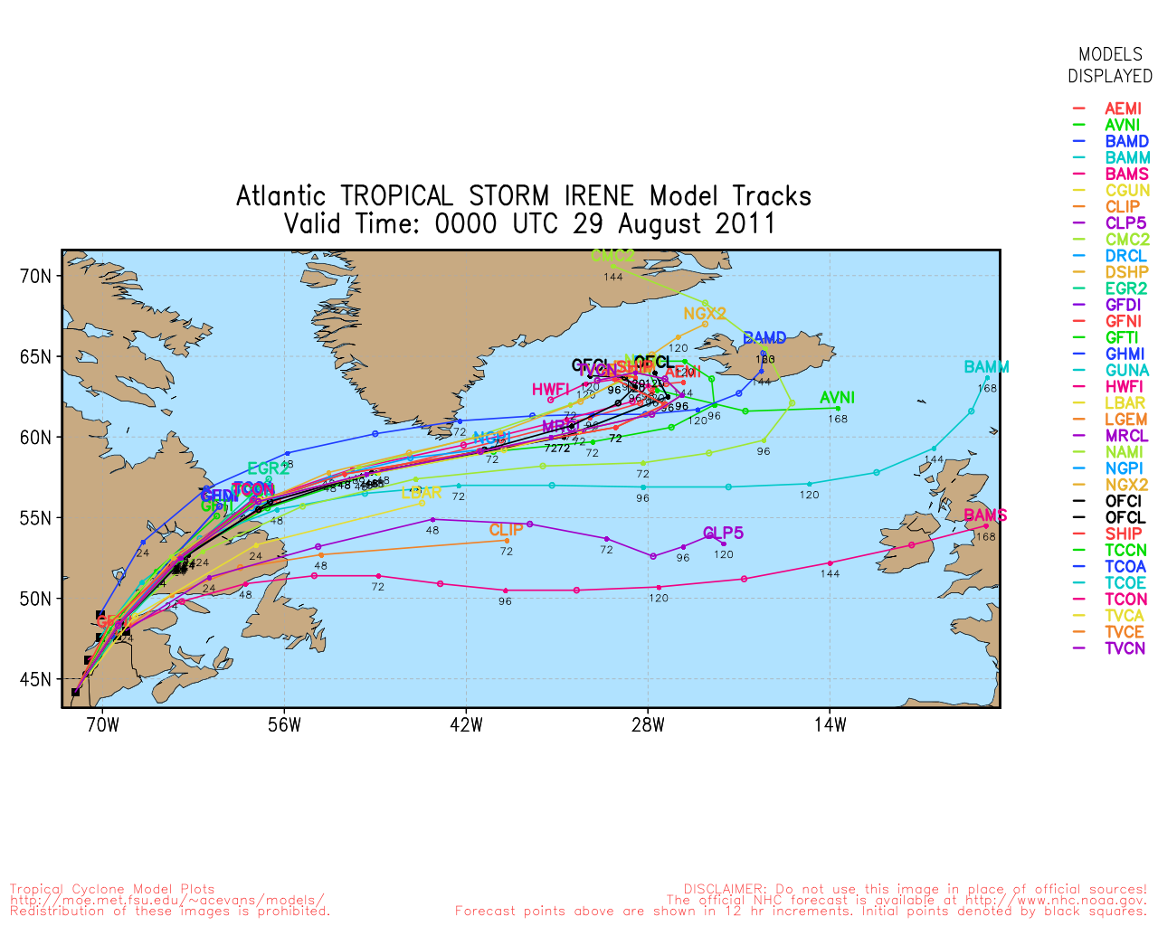
The one fairly clear piece of good news is that, so far as I can tell, none of the models are now calling for the oft-discussed, much-feared New York City nightmare scenario, in which a strong Hurricane Irene would approach the Jersey coast from the due south or south-southeast, sending water flooding into New York harbor. During an on-camera interview with Jim Cantore last night, Weather Channel hurricane specialist Bryan Norcross explicitly raised this possibility, explaining that some computer models showed Irene starting to recurve off to the northeast, but then — atypically, and frighteningly — having that recurvature stall, presumably because one of the shallow steering troughs would lift out to sea without Irene, and a blocking ridge of upper-level high pressure would build back in to take its place, preventing recurvature. This, Norcross said, could temporarily nudge Irene back to the north-northwest, before a later trough would finally pick it up and complete the recurvature. Depending on the timing and location of this sequence of events, Norcross said, the “terrible” New York scenario could be in play. But from everything I’m seeing this morning, it appears that the models are all calling for a single, straightforward recurvature, with the timing and location of that recurvature being the crucial disputed issues. (The storm could absolutely still hit New York and/or New England, but probably not in the manner necessary to cause an epic, catastrophic storm surge in Manhattan.)
Anyway, I’m not qualified to try and referee between the computer models, and won’t attempt to do so. If history is any guide, the next 24 to 48 hours will sort this out, the models will come into better agreement, and we’ll have a lot more confidence by this time Thursday, if not this time tomorrow, what Irene is going to do. The stakes are high, as Dr. Jeff Masters notes:
Though it is still possible the core of Irene will miss the U.S., the current NHC official forecast would mean that Irene would bring destructive flash flooding, significant beach damage, and widespread power outages due to tree damage along the entire U.S. coast from North Carolina to Maine, costing several billion dollars. If Irene ends up skirting the Outer Banks of North Carolina and not significantly weakening, then plowing through the mid-Atlantic and New England states as a Category 1 or 2 hurricane, it could become one of the ten most damaging hurricanes in history. The latest 06Z (2am EDT) run of the GFS model puts Irene ashore in Southeast Massachusetts on Sunday afternoon as a large storm with a central pressure of 974 mb. The latest run of the ECMWF model has Irene with a central pressure of 964 mb over Chesapeake Bay, and 972 mb over New Jersey. These central pressures correspond to strong tropical storm or Category 1 hurricane strengths, and are similar to what Hurricane Floyd or 1999 had when it moved up the mid-Atlantic coast after hitting North Carolina as a Category 2 hurricane. Floyd was the 14th most damaging hurricane in history, with total damages estimated at $9.2 billion (2010 dollars.) Most of the damage was in North Carolina, which experienced its worst flooding on record. If the GFS and ECMWF models are correct, Irene could easily be a $10 billion hurricane, causing widespread damage along a long section of heavily populated coast. The most damaging Northeast U.S. hurricane of all time was Hurricane Agnes of 1972, with damages estimated at $11.8 billion (2010 dollars.) Currently, it appears that Irene will hit North Carolina on Saturday, and New England on Sunday. I strongly urge all residents of the coast from North Carolina to Massachusetts to assess their hurricane preparedness immediately, and anticipate the possibility of hurricane conditions this weekend.
I second that. Now is NOT the time to panic, or to “get the hell out,” but it’s certainly the time to prepare.
Meanwhile, I’ll just note the mantra, which you’ll sometimes hear whispered among weather geeks like myself at times like this, that “the trend is your friend.” Over the last several days, the computer model trend has pushed Irene’s track further and further to the “right,” meaning the eventual landfall target has moved north and east. First we were worried about south Florida, then northern Florida, then the It Could Happen Tomorrow-predicted Savannah nightmare, then South Carolina, now North Carolina, with chatter about the Mid-Atlantic and New England. If that forecast “trend” continues, and the track keeps getting nudged to the right, Irene could well end up staying mostly or entirely out to sea, delivering only a glancing blow to the coast. Years of observation suggest that the “trend” can sometimes be more predictive than any individual computer-model run; hence, “the trend is your friend.” And hence this observation by Dr. Masters:
One reliable model, the UKMET, takes Irene into South Carolina, while several others have the hurricane missing the Southeast U.S. completely, passing just offshore of the Outer Banks of North Carolina on Saturday. The official NHC forecast of a landfall along the North Carolina coast is a reasonable compromise, though with the models trending more eastwards of late, I would favor a landfall farther east than NHC is predicting.
But that’s certainly no guarantee — not even close. Sometimes, a forecast “trend” halts, or even reverses itself. So we’ll just have to wait and see what the computer models say over the next couple of days. Once they start to coalesce around a particular track, we can begin to focus on a more defined target. For now, everybody from Florida to the Canadian Maritimes should be watching Irene. (Florida is seen as a pretty unlikely landfall target at this point, but until recurvature actually begins, Irene remains worth watching even there.)
UPDATE: 5pm EDT update here.


Join the conversation as a VIP Member