

[UPDATE, 10:10 PM Pacific Time: The 0Z GFS computer model is out, and it shifts Irene’s landfall point to the east, again. More here.]
As of 5pm Eastern Time, Hurricane Irene has weakened back to a Category 1 hurricane, with winds of 90 mph. Or more precisely, reading between the lines of the National Hurricane Center’s discussion, the NHC is now acknowledging a bit of weakening that probably really happened sometime last night.
On balance, however, the 5pm advisory is arguably bad news. Yes, Irene has weakened, and yes, wind shear may keep her intensity down a bit, at least for a while. But there’s still a good chance she’ll get to major hurricane status as she approaches the coast. And meanwhile, the track forecast just got a little scarier.
Remember what I said about this morning’s “one fairly clear piece of good news,” that the nightmare scenario painted last night by Weather Channel hurricane expert Bryan Norcross — that Irene might start to “recurve” off to sea, but then its recurvature would stall, and it would temporarily shift course back to the “left” (i.e., north or north-northwest), possibly toward New Jersey or New York harbor — no longer appeared to be in play? Well, the NHC just dumped a bucket of cold water on that “good news”:
AFTER [2 TO 3 DAYS]… IRENE IS FORECAST TO MOVE NORTHWARD TO NORTHEASTWARD AROUND THE ATLANTIC RIDGE. SEVERAL OF THE MODELS… INCLUDING THE GFS… ECMWF… HWRF… AND GFDL… SHOW A TURN BACK TOWARD THE NORTH NEAR THE END OF THE FORECAST PERIOD. THIS APPEARS TO BE IN RESPONSE TO A WEAK TROUGH THAT MOVES THROUGH THE SOUTHEASTERN UNITED STATES BEHIND THE HURRICANE. THE UPDATED TRACK FORECAST HAS BEEN SHIFTED EASTWARD AT 72 AND 96 HOURS BUT THE NEW 5-DAY POINT IS STILL ALONG THE LEFT SIDE OF THE GUIDANCE ENVELOPE… IN AGREEMENT WITH THE MODELS MENTIONED ABOVE.
Specifically, the current forecast track has Irene hitting South Jersey on Sunday.
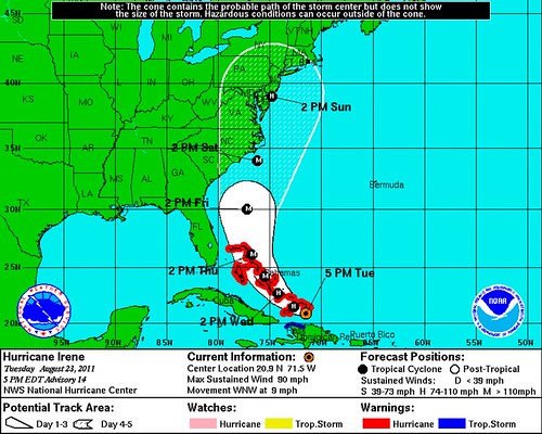
The NHC’s discussion of a possible “turn back toward the north” contradicts what I wrote earlier — possibly because conditions have changed, or possibly because my analysis was simply incorrect. I’m frankly not sure which. I’m just a layman, remember! But either way, this is distressing news. The New Jersey landfall prediction isn’t the point; again, 5-day track forecasts are subject to huge errors. (So, don’t panic, Snooki!) The point is that the NHC has now raised the specter of the dreaded incomplete recurvature, which is a necessary — though by no means sufficient — condition to bring about the New York City nightmare scenario, in which a storm surge would catastrophically flood New York harbor.
Don’t get me wrong. That particular scenario is still unlikely, kids, still very unlikely. But that scenario will always be unlikely, until just before it happens. That’s a big part of the reason why it’s such a troubling scenario.
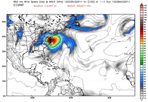
It’s important to note that the “GFS… ECMWF… HWRF… AND GFDL” aren’t just any computer models. There’s a reason the NHC’s forecast track is biased toward the “left side of the guidance envelope,” and it’s not because they’re watching MSNBC. It’s because those particular models are some of the best ones out there. In my previous post, I presented a “spaghetti chart” of the model tracks for Irene and said, “I’m not qualified to try and referee between the computer models, and won’t attempt to do so.” But perhaps I should walk that back a little. The GFS and European (ECMWF) are the some of the more reliable models in existence, and they’re among the ones spitting out some of the scarier scenarios at the moment. The Houston Chronicle‘s Eric Berger elaborates and illustrates:
The latest (12Z) run of the European model, which probably is the best in the world right now, paints a fairly serious scenario showing a very strong hurricane just to the south of New Jersey on Sunday morning.
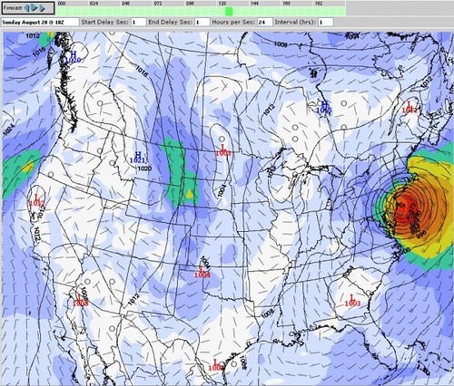
Rendering of the 12Z ECMWF model. (Ryan Maue)The latest GFS model run depicts a similar scenario:
… Under the best-case scenario the storm would continue to veer toward the northeast after [its] encounter with North Carolina, and remain at sea. Some track models are going for this solution. … But that’s far from certain at this time, as the European and GFS models are telling us a more northerly track is possible.
If these two models verify we’re talking about at least hurricane-force winds over parts of the very heavily populated corridor from Washington, D.C. to New York City, and possibly extending most of the way to Boston. There also could be flooding rains.
Berger — who worries that today’s earthquake might distract northeasterners from this looming, potentially far more serious threat — adds, correctly, that there’s “a lot of uncertainty as it pertains to the northeastern threat. Irene could weaken significantly if its center spends a lot of time over North Carolina. It could remain offshore. But simply shrugging this off as another Hurricane Earl would be a mistake.” Agreed. It might turn out to be another Earl, but it might not. We just don’t know yet. For now, the threat is real.
Berger concludes: “Stay tuned.” As they say.


Join the conversation as a VIP Member