

UPDATE (Jul. 15, 09:42 am PST)
Tropical Storm Bertha never quite regained hurricane strength while lashing Bermuda yesterday, and although the island was buffeted by wind gusts as high as 80 mph, Bermudians appear to have emerged from the storm’s wrath relatively unscathed. Several thousand homes lost power, and some trees collapsed onto cars, but there have been no reports of injuries, and the storm appears to have been mostly an inconvenience.
The headlines on the Bermuda Sun‘s website hardly paint a picture of devastation: “Delayed garbage collection as a result of Tropical Storm Bertha,” reads one. “Causeway re-opens after rush hour closure,” declares another.
In fact, the unexpected closure of The Causeway — which connects Bermuda’s two main cities, Hamilton (the capital) and St. George (home of the airport) — appears to have been one of Bertha’s most significant impacts on the island’s population. Monday was initially treated as a “business as usual” day in Bermuda, with most islanders going to work as normal, despite the presence of a strong tropical storm just offshore. The government declared that it intended to keep the Causeway open. But then Bertha unexpectedly strengthened to near hurricane strength, and at 4:55 PM local time, the government changed its mind. As a result:
Some were unable to get back to their families when the Causeway was closed at short notice just before 5 p.m. It reopened just after 8 p.m.
Buses and cars heading to St. George’s were unable to cross the bridge and frustrated motorists and passengers were forced to wait for it to reopen. . . .
The abrupt closing of the Causeway caused problems for those needing to get in and out of the East End but Government said it could not have been avoided.
A spokeswoman explained that information from reconnaissance planes about the dangerous conditions came in at the last minute.
“It’s a funny behaving storm,” she said. “It’s just been up and down and we have just been trying to follow it as best we can.”
[Public Safety Minister David] Burch went on radio station Hott 107.5 to urge the public to be patient while waiting for the bridge to reopen. But callers rang to chastise him for the decision to close at such short notice, with one woman describing how her young son was left home alone because she had assumed she would be able to get across.
American tourist Kathy Borden, from Portland, Oregon, told The Royal Gazette at 7.30 p.m: “We are stuck on a bus with no food and no water and we have got wet clothes on.”
“People have to go to the bathroom and are trying to find places to go outside. We want to know why are the buses are still running if the Causeway is closed?”
Sen. Burch told Hott listeners that the Causeway usually closed if gusts reached 50 knots and last night they got to 69 knots. “Hurricanes are unpredictable and I will accept all criticism from the public for the decision that was made,” he said.
Far be it for me to second-guess the wisdom of local officials in jurisdictions not named Louisiana, but the statement that “it could not have been avoided” is clearly wrong: closing the Causeway all day Monday, as a precaution, would obviously have avoided any possibility of an unexpected last-minute closure. And while hindsight is 20/20, the fact that a 5-mph increase in wind speed was enough to change officials’ minds probably indicates that the wrong decision was made initially. One never knows when a tropical cyclone might suddenly intensify — as Bertha, “funny behaving storm” that she is, has proven repeatedly — so last-minute actions that can potentially strand people in the storm’s wrath are not terribly wise as a matter of policy. Better safe than sorry, as they say.
Closing the Causeway from the get-go would have forced some Bermudians to remain in their homes Monday — rather than commuting to and from work while Bertha was hitting the island — and would have eliminted the possibility of people being forced to wait idly in their cars, on the wrong side of the Causeway, during a hurricane. The latter scenario is pretty much a disaster planner’s worst nightmare, and while Bertha didn’t quite regain hurricane strength, maybe the next similarly situated storm will intensify a bit more than Bertha did, and will pose a more serious danger for the folks who get stranded. Probably better to err on the side of caution next time around, in this weather nerd’s humble opinion.
In any event, here’s how the Royal Gazette summed things up this morning:
Torrential rain and 70 mph winds battered Bermuda yesterday as Tropical Storm Bertha . . . passed over the Island.
Trees collapsed onto cars, thousands of homes suffered power outages and all flights were cancelled as Islanders hurried home to batten down the hatches against hurricane-strength gusts. . . .
Afternoon ferry services were cancelled . . . The cyclone caused waves of between 15 and 20 feet outside the reef and between four and six feet inside.
Bermuda Weather Service duty forecaster Geoffrey Saville said that wind gusts close to 80 mph (70 knots) were recorded at the Commissioner’s House at Dockyard. “That’s pretty strong gusts and that was just what was recorded,” he said. . . .
The wet weather caused some properties to flood, including a home in Whale Bay where firefighters climbed onto the roof to stop water coming through the light fixtures. Meanwhile, almost 7,000 homes were without power from late afternoon. Residential garbage collection was also disrupted as was Internet service for some users.
In Hamilton, rows of motorcycles were knocked to the ground and there were reports of flying debris and intermittent flooding on the roads, as well as poor visibility for drivers. . . . A car overturned near the Waterlot Inn in Southampton at about 2 p.m. but no one was reported to have been injured. . . .
Government offices remained open but some private firms decided to send staff home early and several day care centres sent children home. . . .
[A power-company spokeswoman] said that all but 700 customers had power restored by 9 p.m. Crews were due to continue working till midnight and will resume at 7 a.m. today.
Diane Gordon, executive vice president of the Chamber of Commerce, said she fielded a number of calls yesterday morning from worried businesses but encouraged everyone to remain calm.
“Officially no businesses have been reported closed,” she said, adding that Hamilton had been very quiet at about 3 p.m. meaning some firms probably had let employees go home.
About a thousand travellers — including the victorious Scottish cricket team which beat Bermuda — were affected when all 16 commercial flights off the Island were cancelled[.]
Incidentally, interested readers can learn more about that Scotland-Bermuda cricket match, which took place on Saturday, here (from the Bermudian perspective) and here (from the U.K. perspective). But back to Bertha…
The National Hurricane Center’s 11:00 AM advisory declares that Tropical Storm Bertha, now safely away from Bermuda and moving steadily out to sea, will likely “HANG AROUND FOR A FEW MORE DAYS,” and could become a hurricane again later today or tomorrow. The discussion makes clear that NHC forecasters are getting rather tired of writing about this long-lived storm, which is now a threat only to shipping interests. In about five days, forecaster Eric Blake writes, “A COMBINATION OF COOLER WATERS AND AN UPPER-LEVEL TROUGH INTERACTION MAY…HOPEFULLY…START TO SIGNAL THE DEMISE OF BERTHA AS A TROPICAL CYCLONE.”
By then, we may be dealing with Tropical Storm — or perhaps Hurricane — Cristobal. But there’s no major news yet to report on that front. In fact, the National Hurricane Center has downgraded the probability that “Invest 94L” will imminently become a tropical depression from “High” (above 50%) to “Medium” (between 20% and 50%). Meteorologist and weatherblogger Bryan Woods points out that some computer models have “backed off” their predictions that 94L will develop into Cristobal, and the NHC’s 8:00 AM Tropical Weather Outlook states, “ALTHOUGH THIS SYSTEM STILL HAS THE POTENTIAL TO BECOME A TROPICAL DEPRESSION WITHIN THE NEXT DAY OR SO…ENVIRONMENTAL CONDITIONS ARE BECOMING LESS FAVORABLE FOR DEVELOPMENT.”
UPDATE (Jul. 14, 12:53 pm PST)
It looks like Tropical Storm Bertha may have one last curveball to throw at forecasters. The NHC issued a rare 2:55 PM EDT update to announce a surprising finding: Bertha has re-strengthened to the cusp of hurricane strength!
DATA FROM AN AIR FORCE RESERVE UNIT RECONNAISSANCE AIRCRAFT INDICATE THAT BERTHA IS JUST BELOW HURRICANE STRENGTH…WITH MAXIMUM SUSTAINED WINDS OF 70 MPH. THESE WINDS ARE LOCATED TO THE SOUTHWEST OF THE CENTER IN A RAINBAND THAT WILL BE PASSING OVER BERMUDA DURING THE NEXT FEW HOURS. IT IS POSSIBLE THAT BERTHA WILL REACH HURRICANE STRENGTH BEFORE CLEARING BERMUDA.
As a result, the government of Bermuda has issued a Hurricane Watch for the island, which also remains under a Tropical Storm Warning (rather obviously, since it is currently experiencing tropical storm conditions).
UPDATE (Jul. 14, 12:13 pm PST)

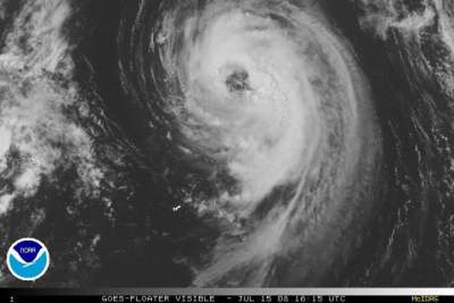
The western eyewall of Tropical Storm Bertha is raking Bermuda this afternoon with heavy rains and sustained winds of at least 63 miles per hour — but the island appears to be faring well thus far. Meanwhile, swimmers along the U.S. East Coast are being urged to exercise caution after two people drowned off the Jersey Shore because of rip currents generated by the distant storm.
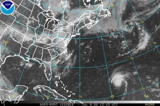
As this excellent radar loop shows, Bertha’s center of circulation came within about 50 kilometers, or roughly 30 miles, of Bermuda. But because Bertha has such a massive eye, the eyewall is passing directly over the island.
A longer-range, longer-term radar loop, showing the storm’s approach,
can be seen here. The visible satellite view also shows the storm’s proximity to the island:

According to the National Hurricane Center’s 2:00 PM EDT advisory, “THE CENTER OF BERTHA IS NOW EDGING AWAY FROM BERMUDA…[BUT] STRONG WINDS IN A RAINBAND TO THE SOUTHWEST OF THE CENTER HAVE YET TO CLEAR THE ISLAND.” It is possible that tropical storm force winds could persist through tomorrow morning as Bertha slowly inches away from the island.
The report of a 63 mile-per-hour sustained wind reading comes from an “elevated” station on Commissioner’s Point, on the western end of the island, according to the National Hurricane Center. It is possible that winds are slightly stronger on the east side of the island, which is marginally closer to the storm’s center. The NHC’s official estimate for Bertha’s maximum sustained surface winds is 65 mph. The storm is moving north at 7 mph.
According to Bermuda newspaper The Royal Gazette:
Tropical Storm Bertha was sweeping by Bermuda this afternoon bringing high winds and rain . . .Seas outside the reef were today between 15 and 20 feet and inside the reef, between four and six feet.
All ferry services were cancelled this afternoon, though they are scheduled to resume tomorrow as normal and buses were running on schedule today. The causeway also remained open.
Flights in and out of the Island were cancelled for all airlines today . . .
Some electricity outages had been reported in both the West and East Ends of the Island.
The island seems to be coping well, however. Dianne Gordon, executive director of the Bermuda Chamber of Commerce, said it’s “business as normal” for most people on the island. And, in a sure sign that things aren’t looking too bleak, the local media is stretching rather severely to find a “harrowing” story about the storm. Again quoting from the Gazette:
For manager of PVC Windows and Doors, John Paul it was a harrowing experience just before mid-day as he watched a tree fall on top of two cars.
He said: “It was so disturbing. It was horrific. I was standing by the door and I heard the crash and a crackling noise. It had two cars underneath the tree.
“The cars were damaged — it didn’t completely crush [them,] but it was lying on them.”
Damaged, not-quite-crushed cars!! Oh, the humanity!! “Other reports of flying debris and intermittent flooding were reported,” the Gazette adds helpfully.
On a more tragic note, at least two people drowned in the waters off New Jersey over the weekend, apparently due to dangerous rip currents caused by Bertha’s high surf.
Although Bertha is many hundreds of miles from the U.S. coast, strong and dangerous waves — generated days ago, when Bertha was a stronger storm — will persist for several more days.
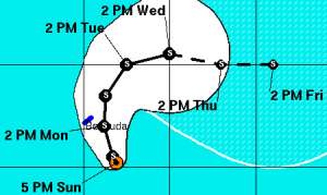
Bertha herself, however, is moving away from land. The forecast track calls for the storm to continue moving north, then turn northeast before meandering eastward in an “undulating” fashion over the next several days. But the storm will be of concern only to shipping lanes from here on out.
Meanwhile, the bigger news in the tropics is arguably what’s happening in the central Atlantic, in between Africa and the Lesser Antilles, with “Invest 94L,” or — as I like to call it — “proto-Cristobal.”
It now seems quite likely that this tropical wave will become a depression, and soon thereafter a storm — Tropical Storm Cristobal — in the next day or two. If so, it will have plenty of warm water to work with as it moves westward, toward the islands, in the coming days. meteorologist Bryan Woods, guestblogging for Dr. Jeff Masters says that, between Bertha and “94L,” the latter “has the potential to create a much higher impact event.”
Woods writes that “the situation bears further watching. This system could eventually end up anywhere in the Caribbean, Gulf of Mexico, or western Atlantic, and at any strength.” It’s far too early to say anything more detailed than that, but it is possible that Cristobal could be the first real blockbuster storm of the season. Stay tuned, as they say.
UPDATE (Jul. 13, 03:23 pm PST)
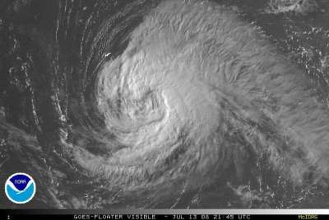
Hurricane Bertha was downgraded to a tropical storm this morning, weakened by cooler waters from beneath the ocean’s surface that her own relentless winds have dredged up.
Yet Bertha remains a “vigorous” tropical storm, with the potential to bring squally weather to Bermuda as she passes just east of the island tomorrow — assuming she obeys the forecasts and actually starts moving again.
Early yesterday, Bertha “SEEMINGLY DROPPED ANCHOR A COUPLE HUNDRED MILES SOUTHEAST OF BERMUDA,” and has barely moved since. As a result, the storm’s winds have churned up the same patch of ocean for more than 24 hours, causing “upwelling,” or cooling of the waters underneath Bertha. That, in turn, has weakened the storm, slowing its maximum sustained winds to 65 mph as of 5:00 PM EDT.
This morning, National Hurricane Center forecaster Lexicon Avila declared that Bertha had begun crawling northwestward — only to correct himself six hours later, stating, “BERTHA FOOLED ME ONCE AGAIN.” In fact, Avila wrote, Bertha had been “moving in circles,” and remained essentially stationary.
The computer models “insist,” however, that Bertha will begin moving tonight. The official forecast brings the storm’s center less than 100 miles from Bermuda tomorrow afternoon. (Already, Bertha’s outer bands can be seen on Bermuda radar. However, the western side of the storm is weaker than the eastern side; in fact, as the visible satellite shows, it’s currently not even cloudy in Bermuda.)
In any event, shortly after passing the island, Bertha is expected to turn more sharply to the east and slowly transition from a tropical storm to an extratropical storm over the open ocean. It is no longer expected to affect Newfoundland.
Bertha was a hurricane for six days, not quite enough to break the record for the longest-lived July hurricane on record. 2005’s Hurricane Emily still holds that mark, at seven days. However, Bertha will most likely break the record for longest-lasting named storm in July (including both tropical storms and hurricanes). The current record is 12 days; Bertha has been around for 10 and counting.
Meanwhile, there is the potential for a new tropical depression to form this week. The system, which has been designated “Invest 94L” by the NHC, sits roughly halfway between Africa and the Lesser Antilles. If 94L becomes a named storm, it would be Tropical Storm Cristobal — and it could potentially threaten the Antilles in about a week’s time.
UPDATE (Jul. 11, 09:02 pm PST)
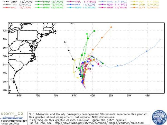
Not much has changed today, as Bertha has continued to inch toward Bermuda. The National Hurricane Center’s 11:00 PM EDT discussion aptly explains the still-uncertain state of Bertha’s future track:
THE SHORTWAVE TROUGH [OF UPPER-LEVEL LOW PRESSURE] CURRENTLY ALONG THE U.S. NORTHEAST COAST WILL ALMOST CERTAINLY BYPASS BERTHA WELL TO THE NORTH…AND NONE OF THE MODELS FORECAST BERTHA TO ACCELERATE AHEAD OF THE NEXT TROUGH WITHIN FIVE DAYS…ALTHOUGH THAT TROUGH LOOKS TO BE STRONGER AND MIGHT TRULY PICK UP BERTHA BEYOND THAT TIME. IN BETWEEN THOSE TWO TROUGHS…THE MODELS DISAGREE ON HOW MUCH OF A RIDGE [OF UPPER-LEVEL HIGH PRESSURE] MIGHT FORM NORTH OF BERTHA…AND SOME OF THEM FORECAST BERTHA TO STALL WITHIN THE NEXT DAY OR TWO. IN ADDITION…MOST OF THE MODELS SHOW AT LEAST SOME SOUTHWARD COMPONENT OF MOTION ON DAY 5…IN RESPONSE TO A CUTOFF LOW FORECAST TO BE NOT FAR NORTHEAST OF BERTHA BY THAT TIME. THE RESULT OF THE COMPLICATED SET OF INDIVIDUAL MODEL TRACKS IS A CONSENSUS THAT LEADS ME TO SLOW DOWN THE OFFICIAL FORECAST JUST SLIGHTLY…ALSO WITH A NUDGE TO THE WEST…ALONG A TRACK SIMILAR TO THE PREVIOUS ADVISORY THAT SIMPLY BENDS BERTHA’S MOTION GRADUALLY TO THE RIGHT… AT A SPEED OF ABOUT [3 TO 4 MPH] THROUGHOUT THE FIVE-DAY FORECAST. SOME ERRATIC MOTION AT SOME POINT ALONG THE WAY WOULD NOT BE SURPRISING.
THE PROBABILITY OF WINDS OF TROPICAL STORM FORCE OCCURRING IN BERMUDA WITHIN THE NEXT FIVE DAYS…AS CONVEYED IN THE WIND SPEED PROBABILITY PRODUCT INCLUDED IN EACH ADVISORY PACKAGE…HAS BEEN GRADUALLY RISING DURING THE PAST COUPLE OF DAYS…AND HAS NOW REACHED 58%.
The graphic below shows the tracks suggested by the various computer models:
UPDATE (Jul. 11, 08:43 am PST)
A Tropical Storm Watch has been issued for Bermuda, as Hurricane Bertha — now a Category 1 storm with 85 mph winds, an “annular” shape, and a huge eye — slowly meanders toward the island.
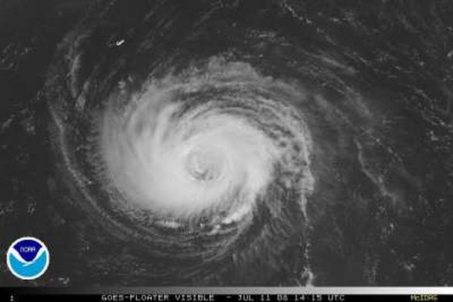
The official forecast track continues to show Bertha’s center passing well east of Bermuda. However, the forecast remains uncertain due to weak upper-level steering currents. Bertha is moving very slowly, and is expected to do so for the next few days.
Moreover, Bertha is a large storm — particularly after the eyewall replacement cycle that occurred yesterday and this morning — so there is a good chance that Bermuda will at least see tropical-storm force winds from her outer bands. Indeed, weatherblogger Alan Sullivan writes that those bands “are not too far from Bermuda now,” and “squalliness could begin there tonight.”
Meteorologist and weatherblogger Dr. Jeff Masters wrote this morning:
There is about a 47% chance the island will experience sustained winds of tropical storm force (40 mph), according to the latest tropical storm wind probability forecast by NHC. None of the computer models currently foresee that hurricane force winds will impact the island, but given the very weak and unpredictable steering currents forecast to affect Bertha by Sunday, the storm could easily approach closer to the island than the current official forecast.
Those “weak and unpredictable” upper-level winds continue to wreak havoc on the forecasters’ ability to forecast Bertha’s path. Sullivan succintly summarizes the divergence among the computer models as follows: “[Most] models still indicate a slow turn to the NNE. Some models make a sharper turn eastward. Some stall the storm right near Bermuda.” The latter scenario would result in a sustained battering for the island, albeit from a weakening storm, as the waters under Bertha would cool due to “upwelling” if she stalls.
Absent upwelling, Bertha could easily strengthen. The eyewall replacement cycle that produced her current, 70-mile-wide eye, is apparently complete, which opens the door for intensification. The 11:00 AM discussion by National Hurricane Center forecaster Lexicon Avila acknoweldges this possibility, even while declining to predict it:
ALTHOUGH IT APPEARS THAT THE OUTER EYEWALL COULD SHRINK RESULTING IN INTENSIFICATION…I AM NOT CONSIDERING IT IN THIS FORECAST BECAUSE I HAVE NO IDEA WHEN OR IF THIS CYCLE WILL OCCUR.
Dr. Masters is bolder, stating that “intensification back to Category 2 status seems probable, and Bertha still has an outside chance at reaching Category 3 status again.”
An additonal wrinkle in the intensity forecast comes from Avila’s observation that Bertha’s “current cloud pattern configuration” is “annular type.” Annular hurricanes are typified by “a large, symmetric eye surrounded by a thick ring of intense convection,” and they are “not prone to the fluctuations in intensity associated with eyewall replacement cycles,” or ERCs. If Avila is correct and Bertha is becoming annular, its just-completed ERC could be its last, which would increase the likelihood of intensification — so long as the water remains warm and shear remains low.
Regardless, Bertha should begin to weaken after 36-48 hours or so, either because the water will cool as she treks northward, or because the water will cool because of “upwelling” after she stalls out. Yet that should be enough time for Bertha to set a new record as the long-lasting July hurricane in recorded history.
In any event, the biggest news regarding Bertha’s intensity today may be one that has nothing to do with atmospheric trends, and everything to do with observational methods. For the first week of this storm’s life, the NHC has been relying on remote measurements of its strength: satellite photos, microwave images, and so forth. However, a reconaissance plane is scheduled to fly into Bertha this afternoon to take more direct measurements. Avila forthrightly acknowledges in the 11:00 AM discussion that “I WILL BE MORE CONFIDENT WITH THE INITIAL INTENSITY WHEN THE PLANE GETS THERE.” Expect some signficant refinements to both the track and intensity forecasts later today, after the data from the recon mission is received and processed.
One final note: Bertha could affect Newfoundland, probably as a tropical storm transitioning into an extratropical system, in about a week.
UPDATE (Jul. 10, 09:10 am PST)
So much for “plateauing.” The wind shear mentioned in my last update has taken its toll, and Bertha has been downgraded as of 11:00 AM EDT to Category 1 status with 90 mph winds — an estimate that “could be a little generous,” as the National Hurricane Center discussion acknowledges. It is not clear what Bertha will do next, and it is becoming increasingly clear that trying to predict this storm’s intensity fluctuations is probably a fool’s errand. NHC forecaster Jack Beven states forthrightly that “THE INTENSITY FORECAST IS A CONUNDRUM.”
Predicting the storm’s track, and possible impact on Bermuda, is similarly challenging. The official track is essentially unchanged, and shows Bertha passing about 200 miles east of Bermuda on Sunday. But, in Beven’s words, “THERE IS A POSSIBILITY THAT BERTHA COULD JOG LEFT OF THE FORECAST TRACK CLOSER TO BERMUDA.”
UPDATE (Jul. 10, 06:51 am PST)
Hurricane Bertha looks increasingly like a potential threat to Bermuda. Weatherblogger Alan Sullivan, in a post this morning titled “Bertha Bermuda-Bound,” writes:
The model consensus projects only a very slow curve to the [north], and continued slow forward motion. It will be several more days before Bertha reaches the immediate vicinity of Bermuda. At this point it does appear possible that the island will be threatened. Typically hurricanes that pass there are accelerating, and the effects are brief. This could be a lot more serious because of the slow forward motion. High pressure is predicted to build very far north in the Atlantic. It may yet turn Bertha due west for a time, at a latitude where such a course would be quite unusual.
The National Hurricane Center’s 5:00 AM discussion says much the same thing, albeit in more wonky terms:
BEYOND [48 HOURS]…THE TRACK FORECAST IS COMPLICATED BY THE FACT THAT THE DYNAMICAL MODELS…IN PARTICULAR THE GFS…SHOW A MID-LEVEL ANTICYCLONE DEVELOPING TO THE NORTH OF BERTHA IN AROUND 72 HOURS. THIS DEVELOPMENT WOULD AT LEAST RETARD THE NORTHWARD PROGRESS OF THE HURRICANE AND…IF THE ANTICYCLONE TURNS OUT TO BE STRONG ENOUGH…COULD EVEN FORCE A TURN TO THE LEFT AS INDICATED BY THE GFS. THE GFDL AND HWRF MODELS RESPOND TO THE INCREASED RIDGING MAINLY BY SLOWING THE TROPICAL CYCLONE AS IT CROSSES 30N LATITUDE. IT IS CERTAINLY POSSIBLE FOR BERTHA TO MOVE ERRATICALLY IN ABOUT 3 DAYS…BUT THE DETAILS OF THAT MOTION ARE OF COURSE UNKNOWN.
In other words: if you’re in Bermuda, or planning a trip there, you definitely need to stay tuned. Although the official forecast track still shows the storm remaining well east of the island, that forecast is very uncertain, and definitely subejct to change.
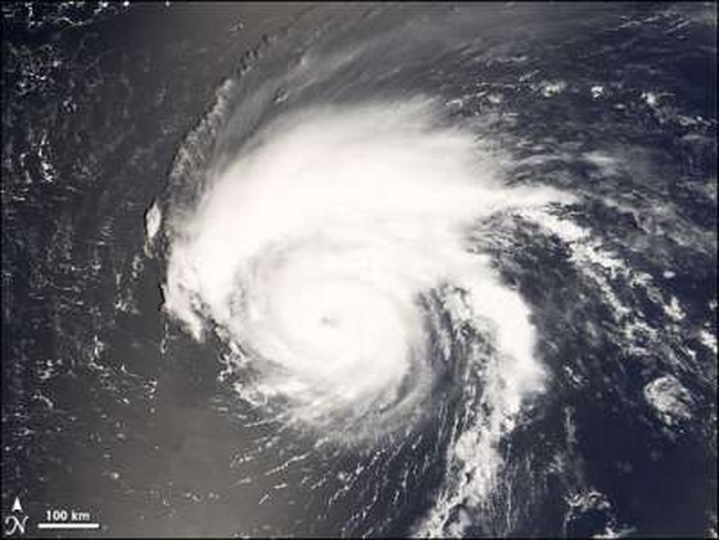
(Photo credit: NASA)
Bertha’s strength, meanwhile, appears to have plateaued — at least for the moment — after several days of rapid, unpredictable, on-again-off-again strengthening and weakening. She’s still a Category 2 hurricane with 105 mph winds, and further intensification is being prevented right now by wind shear and dry-air entrainment. “Continued shear should
prevent Bertha from returning to major hurricane status,” Sullivan writes. But the shear doesn’t appear strong enough yet to weaken Bertha, and she will spend the next 3 to 4 days “over waters warm enough to maintain it at hurricane intensity,” according to Dr. Jeff Masters. That sets up the potential for Bertha to break Hurricane Emily‘s record for longest-lasting July hurricane on record.
After 3-4 days, “wind shear is expected to increase to 30 knots, which should knock Bertha down to tropical storm status,” Masters writes. But that shear prediction is related to the same upper-level steering currents that are giving forecasters headaches in trying to project Bertha’s track, so I’m not sure how reliable it is. In any event, I wouldn’t put much stock in any 3-4 day intensity forecast, particularly with this storm.
Elsewhere in the weather-blogosphere, meteorologist Tim Heller of Houston’s ABC 13 looks at the lessons of Bertha, and AccuWeather’s Jesse Farrell compares Bertha of 2008 with Bertha of 1996.
UPDATE (Jul. 9, 2:15 pm PST)
The National Hurricane Center at 5:00
PM upgraded Hurricane Bertha back to Category 2 status, with 105 mph sustained winds. The official forecast calls for the storm to return to Category 3 strength with 115 mph winds within 12 hours, and stay that way through 36 hours, after which a “slow weakening trend” is expected to begin. In the mean time, however, “BERTHA IS FORECAST TO BE IN A SEEMINGLY FAVORABLE
ENVIRONMENT FOR THE NEXT DAY OR SO,” and she “COULD BECOME A LITTLE STRONGER THAN CURRENTLY FORECAST” during that time.
The official forecast track remains essentially unchanged, but it is still uncertain whether Bertha will impact Bermuda.
UPDATE (Jul. 9, 08:23 am PST)
Reports of Hurricane Bertha’s demise appear to have been somewhat exaggerated. Contrary to my earlier prediction that Bertha might weaken to tropical storm status sooner than expected, the hurricane has reorganized over the last half-day or so, and now appears to be back on an upward trend. Dr. Jeff Masters writes that “further intensification is likely today. None of the models are predicting a return to Category 3 status again” –of course, they didn’t predict it the first time, either– “but Bertha could become a Category 2 hurricane again before wind shear increases once more later this week.”
The National Hurricane Center, for its part, is basically waving the white flag of surrender when it comes to predicting Bertha’s future intensity. Forecaster Rhome, apparently humbled by the unexpected twists and turns of recent days, writes at 11:00 AM Wednesday:
THE INTENSITY FORECAST CONTINUES TO BE CHALLENGING. IN THE SHORT-TERM…THE ATMOSPHERE APPEARS FAVORABLE FOR STRENGTHENING AND THE OCEAN IS PLENTY WARM. HOWEVER…THE VARIOUS INTENSITY MODELS ARE NOT IN GOOD AGREEMENT ON HOW MUCH OR EVEN WHEN REINTENSIFICATION MIGHT OCCUR. GIVEN THE CURRENT TREND IN THE SATELLITE PRESENTATION…THE OFFICIAL FORECAST ASSUMES SOONER RATHER THAN LATER AND SHOWS BERTHA STRENGTHENING DURING THE FIRST 24 HOURS. THEREAFTER…BERTHA WILL BE MOVING OVER WARMER WATERS BUT WITH INCREASING VERTICAL SHEAR MAKING IT UNCLEAR WHETHER INTENSIFICATION WILL CONTINUE. GIVEN THE UNCERTAINTY…THE OFFICIAL FORECAST CONTINUES THE PREVIOUSLY SHOWN TREND OF SLOW WEAKENING. AS THE ABOVE SHOWS…THERE IS CONSIDERABLE UNCERTAINTY IN THE INTENSITY FORECAST.
Translation: “We have no freakin’ clue what’s going to happen.”
The track forecast also remains uncertain. Rhome notes that “TRACK MODELS HAVE NOT DEMONSTRATED GOOD RUN TO RUN CONSISTENCY” — in other words, the computer models can’t make up their minds, and instead keep shifting this way and that. As a result, the NHC emphasizes again that “IT IS STILL TOO EARLY TO KNOW WHETHER BERTHA WILL HAVE AN IMPACT ON BERMUDA.”
ORIGINAL POST (Jul. 8, 1:56 pm PST)
While most Americans were enjoying cookouts and fireworks over the Fourth of July weekend, Mother Nature was cooking up some fireworks of her own, as an historic hurricane formed and unexpectedly intensified over the far eastern Atlantic.
When Tropical Depression Two became Tropical Storm Bertha on July 3, it immediately entered the record books. Bertha, a rare “Cape Verde” storm in early July, formed just 500 miles off the coast of Africa — further east than any other Atlantic storm so early in the season, at least since the satellite era began in 1967.
And Bertha didn’t stop there. As meteorologist and weatherblogger Dr. Jeff Masters noted Tuesday morning, “Bertha now holds the record for farthest east formation as a tropical storm, hurricane, and major hurricane, so early in the season.” Moreover, she is “the sixth strongest early-season Atlantic hurricane on record” — and history may eventually record that she was even stronger than that.
Bertha strengthened only gradually at first, reaching sustained winds of 50 mph by Sunday morning. At that point, however, an unexpected burst of rapid intensification began. The result was another humbling experience for forecasters, whose computer models remain much better at predicting hurricanes’ tracks than at forecasting their intensities.
The National Hurricane Center’s (NHC) public advisory at 11:00 AM Sunday stated that “GRADUAL STRENGTHENING IS FORECAST DURING THE NEXT COUPLE OF DAYS,” and the discussion predicted that Bertha would be a 65 mph tropical storm in 24 hours, a 70 mph tropical storm in 36 hours, and a minimal hurricane with 75 mph winds in 48 hours.
What actually happened was considerably more dramatic. Bertha reached 60 mph strength at 5:00 PM Sunday, then 65 mph at 11:00 PM Sunday; became a Category 1 hurricane with 75 mph winds at 5:00 AM Monday; approached Category 2 strength with 90 mph winds at 11:00 AM Monday; and then, bypassing Category 2 entirely, exploded into a Category 3 major hurricane with 115 mph winds at 5:00 PM Monday. And she may have been even stronger:
Bertha may even have intensified to Category 4 status between [4:00 PM and 8:00 PM Monday]. Satellite estimates of the storm’s intensity…during that period were 115 knots (135 mph), which would have made Bertha a low-end Category 4 hurricane. However, it is unclear what Bertha’s final official intensity maximum will be, since it reached maximum strength in between the official 6-hourly times used by NHC to document a storm’s strength.
Bertha’s peak — whether at 115 mph, 135 mph, or somewhere in between — happened just 30 or so hours after she was a weak tropical storm with 50 mph winds. And it was “somewhat surprising,” given that “environmental conditions for intensification were good, but not great.” The water was only lukewarm, and wind shear was only mildly calm, yet Bertha deepened as if she were sitting over a perfectly calm, Gulf of Mexico-like bathtub. Chalk up another victory for the mysteriousness of hurricanes.
“BERTHA’S INTENSIFICATION TO MAJOR HURRICANE TODAY HIGHLIGHTS THE DIFFICULTIES OF FORECASTING RAPID INTENSITY CHANGES,” National Hurricane Center forecaster Jamie Rhome wrote at 5:00 PM Monday. Weatherblogger Alan Sullivan was more blunt, writing at 3:46 PM Monday, in a post titled “Throw Out the Models“:
Bertha has strengthened explosively today. … Throw out the models. None of them foresaw this. Although models rightly foresaw the storm’s formation – I was skeptical about that – they consistently underestimated this cyclone once it got going.
Bertha has since weakened, dropping back to Category 1 status as of 5:00 PM Tuesday. The official forecast now calls for Bertha to be downgraded to a tropical storm in 72 hours, and it wouldn’t be terribly surprising if that happens sooner.
As Sullivan wrote Tuesday morning: “Southwesterly shear is now degrading Bertha as fas as yesterday’s windlessness strengthened it. Hurricanes are fickle. Their energies are vast, but the least disturbance of their symmetry sometimes tears them apart.” Forecaster Rhome made a similar observation in the 5:00 PM discussion, and once again emphasized the degree to which Bertha has humbled the forecasters:
BERTHA’S RAPID INTENSIFICATION YESTERDAY HAS BEEN EQUALED BY ITS RAPID WEAKENING TODAY. SUCH INTENSITY FLUCTUATIONS REMAIN A FORECASTING CHALLENGE AND SERVE AS AN IMPORTANT REMINDER FOR THE UNCERTAINTIES ASSOCIATED WITH INTENSITY FORECASTS.
There is some indication that Bertha might regain some strength in a few days, but in light of the difficulty forecasting this storm’s intensity, the NHC appears gun-shy about actually predicting such a thing, instead calling for “SLIGHT WEAKENING IN THE SHORT-TERM WITH LITTLE CHANGE THEREAFTER.”
Intensity forecasting snafus aside, the million-dollar question is where Bertha will go — and the storm’s sudden and unexpected fluctuations in strength have had a lot to say about the answer to that question.
Early in Bertha’s life, forecasters predicted that an upper-level trough would pick the storm up and “recurve” it toward a more northerly track, away from the U.S. coast. However, back when Bertha was a weak tropical storm, that consensus evolved and changed. It appeared for a while that Bertha would not be strong enough to “feel” the pull of the trough, and thus she would probably continue trekking westward for at least a while longer. Meteorologist and weatherblogger Dr. Jeff Masters discussed this possibility in a Saturday-morning post titled “Bertha may pose a long-range threat to the U.S.”
Later, when Bertha rapidly strengthened, another concern arose, expressed by Sullivan in his “Throw Out the Models” post:
Now [Bertha] is strong enough to alter the upper level systems in its path, perhaps overwhelming them altogether. While the forward motion has slowed and will probably jog NW for a time, I expect a more westward turn may follow. Bertha has already gained enough latitude that it probably won’t threaten Florida, but risk is increasing for the Carolinas.
The storm’s subsequent weakening, however, has significantly reduced that risk. Sullivan himself acknowledged as much Tuesday morning, writing, “I threw out the models too soon. Bertha has not gotten quite far enough west to tuck itself under the Bermuda high, which is not very strong at present.” Sullivan said he “can now see how the model scenario for slow recurvature might play out,” and that “the original guess for Bertha’s course” appears likely to be correct. In other words, no threat to the U.S. coast, and probably no threat to Bermuda. Bertha “will be out there for many days, making nice, long-period swell for East Coast surfers,” but will most likely never impact land.
There remains some uncertainty in the track, however. The NHC’s most recent discussion notes that changes in the upper-level wind patterns “COULD RESULT IN THE STEERING CURRENTS BECOMING RATHER WEAK BEYOND 72 HOURS…AND BERTHA COULD MOVE SLOWLY AND ERRATICALLY TOWARDS THE END OF THE FORECAST.” For this reason, Bermuda residents should continue to monitor Bertha, lest she throw another unexpected curveball at forecasters.
As Dr. Masters put it Tuesday morning:
All of the computer models turn Bertha northwards east of Bermuda, and it currently appears that the island will feel only peripheral effects of Bertha. However, the trough of low pressure turning Bertha to the north may not be strong enough to fully drag the storm into the far North Atlantic, so Bertha may wander close to Bermuda early next week while it waits for another trough of low pressure to finish the job. It is very unlikely Bertha will threaten the U.S., but it could eventually affect Newfoundland, Canada.
Assuming that Bertha itself remains a concern purely for sailors, surfers and fish — and perhaps Newfoundlanders — the final question of interest is what, if anything, it portends for the remainder of hurricane season. The level of early-season activity generally is not a solid indicator of whether a whole season will be active or inactive, but early-season Cape Verde storms are a different matter.
Dr. Masters discussed this issue in his initial post about Bertha’s formation, writing:
Is the formation of Bertha a harbinger of an active hurricane season?
Probably. According the the Hurricane FAQ, “as shown in (Goldenberg 2000), if one looks only at the June-July Atlantic tropical storms and hurricanes occurring south of 22°N and east of 77°W (the eastern portion of the Main Development Region [MDR] for Atlantic hurricanes), there is a strong association with activity for the remainder of the year. According to the data from 1944-1999, total overall Atlantic activity for years that had a tropical storm or hurricane form in this region during JJ have been at least average and often times above average. So it could be said that a JJ storm in this region is pretty much a ‘sufficient’ condition for a year to produce at least average activity.”
Only time will tell whether Bertha is truly a harbinger of things to come, but at least for now, you can add this unusual early-July monster to the list of reasons why the seasonal forecasters might just be right this time.


Join the conversation as a VIP Member