Major New York City Flood Appears Imminent
[NOTE: Follow me on Twitter for my very latest updates on Hurricane Sandy. To track live data, including tidal gauges, buoys, satellite and radar, go to my "One-Stop Shop" landfall tracking post.]
* * * * *
If my reading of the Battery Park tidal gauges (charts here and here; raw data here) is correct … and if my understanding is right that a water level (i.e., the red line on the charts) higher than 10 to 10.5 feet would cause a major flooding event in New York City that would inundate the subways and swamp low-lying areas of the city … it appears to me that, unless the storm surge (i.e., the green line on the charts) slows down from its current pace of increasing approximately 1 foot per hour, a significant New York City flooding event will begin sometime in the 5:00 to 6:00 PM hour local time, probably closer to 5:30 or 5:40 PM, but in any event well before the 9:00 PM high tide (and thus, presumably, continuing unabated for several hours).
Tidal Gauge at The Battery, New York, NY:
Caveat: I’m neither a meteorologist nor a hydrologist. But I can do arithmetic, and this is what I’m seeing.
If you are in a flood-prone area in New York City, and you are reading this, and you can get safely to higher ground, DO SO IMMEDIATELY!!!
I hope and pray that everyone who needs to be on higher ground is already there, and that this is solely a property damage event, with no loss of life.
The same goes, of course, for New Jersey and Long Island and Connecticut and everywhere else. I’m just focusing on New York City here because, well, it’s New York City. But the suffering is going to be widespread.
UPDATE, 4:21 PM: Literally as I was publishing this, the surge’s acceleration slowed down from ~1 foot of additional surge per hour, to ~1/2 foot of additional surge per hour. (That’s on top of the normal increase in water level due to the tide coming in, i.e., the blue line.) But this deceleration only delays the inevitable. Unless the storm surge (green line) not only slows its increase, but reverses itself and begins going down — which presumably won’t happen until the winds from Sandy shift, which does not appear imminent — the NYC flood will begin no later than 7:00 PM, and likely sooner.
UPDATE, 5:15 PM: Knock furiously on wood, but it appears that the storm surge stopped rising at 4:40 PM, and may now be very slowly decreasing. (The overall water level is still going up, but the storm surge — the difference between a “normal” tide and the surge-driven tide — is now stalling or dropping.) This is probably related to Hurricane Sandy’s acceleration toward the coast; the storm made a further left turn, and is about to make landfall. It is now possible that NYC will be spared the major flood that appeared imminent 90 minutes ago. However, it is going to be a very, VERY close-run thing, and a significant flood is still entirely possible. As it stands now, the current 6.6-foot storm surge would, without any further increase, be enough at high tide (which would be 4.74′ today with no surge) to push total water levels to 11.34′. So we need the surge to drop somewhere between 1 and 1.5 feet in the next few hours.
UPDATE, 5:44 PM: The surge is plateauing, not dropping, so for now, we’re still on course for the water level to reach 10 feet around 6:30 PM, and 10.5 feet around 7:00 PM, peaking at 11.4 feet just before 9:00 PM — if the surge doesn’t start to drop by then. That timing assumes the surge holds steady at 6.7 feet; the projected water level rise is due solely to the “normal” tide coming in.
New York City may well still flood, but at a minimum, if this trend holds, the flood will be less severe and less long-lasting than if the surge had kept accelerating, as it likely would have if Sandy hadn’t taken the left turn and sped up toward the coast.
UPDATE, 6:16 PM: It now appears the surge (green line) has resumed increasing, albeit at a much slower rate: 0.02′ per 6-minute update on the tidal data, or 0.2′ per hour. If that continues, the total water level will top 10′ very shortly — at around 6:20 PM — and will top 10.5′ at around 6:45 PM.
UPDATE, 6:36 PM: The water level at the Battery has topped 10 feet and will soon reach 10.5 feet, with 2 1/2 hours until high tide. I assume that the flood is underway, though I haven’t seen confirmation of that yet.
UPDATE, 7:10 PM: Parts of New York City are, indeed, flooding. Here are two photos by Julian Ehrhardt, apparently in Brooklyn:
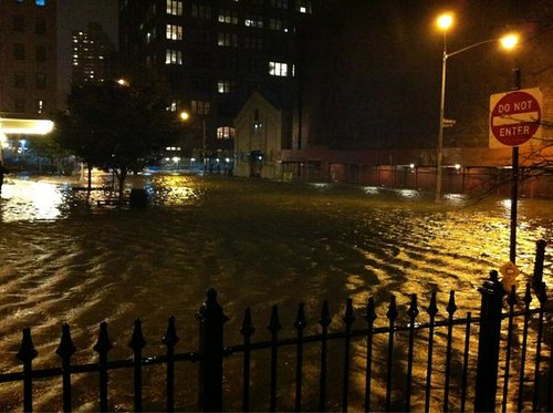
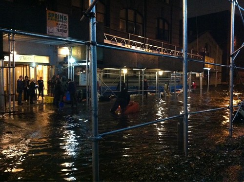
Parts of Lower Manhattan are reportedly flooding, too, and power has been shut off because of the flooding. See my Twitter feed for the latest.
UPDATE, 7:49 PM: The surge is accelerating again, increasing at a pace of more than 1.5 feet per hour over the last 30 minutes. Surge is now 8.41′, water level is 12.75′. If this surge pace continues, the water level will be above 15′ by high tide, more than 10′ of it from the surge alone.
Again, see my Twitter feed for the latest.


This might be a good time to remind people to heed warning signs, like Emergency/Danger tape. The FDNY put up tape shutting down a block and left. The danger, a downed power line, is live. Flames are shooting out sporadically. Anyone out for a stroll is in real danger until the power is cut.
But what should we do about the Big Gulps??
This is something that transcends politics. A disaster like this calls for humanitarian aid and empathy for those who will be adversely affected, and please, political observers, eschew the usual snarky comments.
One can despise the Mayor, and point out where his priorities have been, and still empathize with the victims of his stupidity. In fact, I’d assert that such empathy does, in fact, fill me with anger toward stupid politicians.
In your one-stop shop you have a wave height graph from a bouy at the entrance to NY Harbor. When I just looked it was showing 27 foot wave heights. I expect those are breaking and thus getting lower as they get closer to land. Do you know how much?
Except for the personal tragedies, but I really don’t care what happens to NYC. The arrogant aristocrats have tried to rule over flyover land for too long. Let the ocean “redistribute” NYC’s wealth.
The wind map over NJ looks pretty interesting. This thing really blew up as it sped up (no surprise). It is several hours ahead of schedule.
Hard to tell if this is a wet storm overall. Pretty warm, also. Looks like it.
Winds are now mostly out of the N and NW over much of NJ. Southern NJ and the DelMarVa now are distinctly off shore.
Winds over Manhattan are bucking to the North (hard to picture massive flooding unless there is some giant reservoir around Albany that is going to bust loose.) Maybe the back side winds will push into NY Harbor. We’ll see what the backside will be. High tide at 2100, give or take, East River, Brooklyn Bridge.
This came in a bit north and really blew up to give frontside wind surge to NYC. Back side does look fairly dry.
The eastern approaches to the City are still getting easterlies. There will be, for the time being, a lot of Long Island Sound headed westward. I’d suspect City Island will get it. Also, low lying areas of the Bronx. Love to get a water report out of LGA. Winds there are NW at 45 and swinging against the clock. There are stations on the eastern LI south shore that are still indicating strong due south, if that is not noise then the south shore is getting it also. Montauk might be the story.
Da’ nues likes to put people on the beaches but I think this is going to be far worse inland. I do not have a foliage report but I bet limbs are pretty heavy. Massive power issues.
Zoomed Wondermap out to include Columbus Ohio and the only freezing temps were in So W.VA. I suspect some overnight snow in the highest of hills. We sons of the west can never call what they have on the east coast mountains
Here is the wondermap Zoom in and zoom out to get more/less stations and you can scroll around like with any GoogMap.
The line coming out from the circle is the direction the wind is coming from and the number of bars is the speed.
http://www.wunderground.com/wundermap/?lat=40.08012009&lon=-74.06844330&zoom=8&pin=Point%20Pleasant%20Beach%2c%20NJ
Haha. I love Fox News, except when it comes to science and geography. Bret just had this coming ashore now at Ocean City, MD. Crazy. Janice Dean LOL. If they want sensational video they better head out to the eastern LI south shore or western LI Sound.
At 6:30 it looks like the winds are veering to the south to feed water straight up New York Harbor. The wind will probably continue to pile water into the harbor for a fair bit longer. Added to that is the wind being more easterly in Long Island Sound blocking the water going up the East River.
I am hearing reports of power being cut. Tweet from NYC mayor:
@ConEdison says they may need to shut down underground networks in Lower Manhattan and Brooklyn
Kings Point is at 12 ft above predicted and rising from the minimum low tide. Kings Point is on the Eastern Long Island shore. That water has to be entering the East River trying to flow down to The Battery.
Oops, I confused myself. Kings Point in on the Western end of Long Island’s northern shore. You can see the Chrysler building from the Merchant Marine Academy’s waterfront.
ENE 18 mph @ 1900 Central Park
Let’s see
FDNY via Scanner: “We have about 2 ft of water at 14th St and Ave C
Yep
Western LI gets it when winds out of the east
Bottle neck – funnel effect
Piles up
It is not just speed that piles it up but duration
Flooding at Battery Park
http://twitter.yfrog.com/kemlijraj
BREAKING: The water level at the Battery in #NYC has reached 11.25 feet, surpassing the all-time record of 11.2 feet set in 1821\
Also, hearing that power is going to be cut below 36th street.
The NYC situation is Awful — and not just in Lower Manhattan but also in some swaths of the more-enlightened precincts of Queens & Staten Island :} — but that’s not All. The flooding is also Horrendous all along the north coasts of Nassau & Suffolk Counties on Long Island, and the entire coastline of Connecticut from far-eastern-corner Stonington westward to (gasp!) the shoreline redoubts of Old Greenwich. AND, likewise in coastal Rhode Island. Delaware, New Jersey & Maryland. / And Now it’s to be Onward to more-inland Baltimore & Philadelphia. / Oh, the Aftermath of this goddam thing may make Katrina’s look like the proverbial Picnic.
Hope the blue staters suffer…
I have to say Brendan, you and a few other forecasters called this one right on the nose. Just amazing to us non techies. Very good job, I just wish that the politicos had taken heed of all of your warnings. Seems Christie did, at least I think so from what I know about it.
Seems like there is going to be a terrible after math of this storm. So much damage, I hope and pray the loss of life will be as low as possible.
Again, thanks for a very informative and spot on blog.
I do not even know how I stopped up here, however I thought this submit used to be good. I don’t know who you might be however definitely you are going to a famous blogger should you are not already. Cheers!