

[NOTE: Follow me on Twitter for my very latest updates on Hurricane Sandy. To track live data, including tidal gauges, buoys, satellite and radar, go to my “One-Stop Shop” landfall tracking post.]
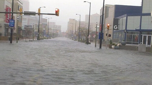
(Photo by christimallia on Instagram.)
It’s looking bad out there, as the above photo of Atlantic City, NJ indicates. Any hopes that Hurricane Sandy had been “overhyped” — that its storm surge would underwhelm, like Irene’s did in many places; that computer models’ forecast of last-minute deepening was implausible and wouldn’t happen; or perhaps that Sandy would simply turn away and go out to sea — have now been dashed. A disaster is underway. The only question is how severe it will end up being.
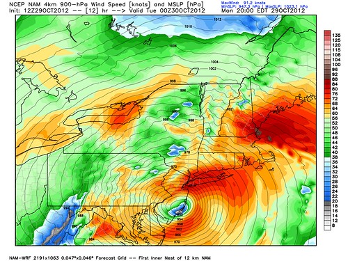
What’s happening is precisely what the computer models have said, consistently for days now, was going to happen. Sandy is strengthening in the hours before landfall — down to an incredible, record-setting 937.5 millibars, according to the most recent reconnaissance data, a drop of 6 millibars in less than 2 hours (!). At least one buoy, about 100 miles south of Montauk, NY, is reporting extreme wind gusts equivalent to Category 3 strength, although I have some doubts about that data. Regardless, the recon planes flying over the storm have measured increasing wind speeds near the center, prompting the NHC to estimate that Sandy now has 90 mph sustained winds at the surface. That suggests we could see a few 100+ mph gusts right on the coast. This is presently closer to a Category 2 hurricane than it is to a tropical storm.
Even more significantly, and also precisely as expected, Sandy is pushing an enormous storm surge toward the heavily populated coastline, well ahead of its center, as it makes the long-forecast sharp left turn that will force the full brunt of this uniquely destructive storm directly into the mid-Atlantic coast. More specifically, it now appears that Sandy will hit South Jersey or Delaware Bay this evening around 8:00 PM local time. Check out the NCEP NAM model forecast from WeatherBell:
8:00 PM is right at high tide, on the button, in Atlantic City — so that’s an extremely destructive scenario. It’s going to get even worse — and it already looks quite bad:
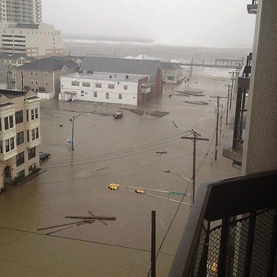
That photo of Atlantic City is by @NNJ_WxAuthority. See also Ken Shane’s photo of Ocean City, NJ (just south of Atlantic City):
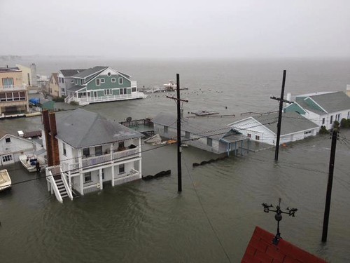
(That’s one of several great pictures Ken Shane has posted.)
As I mentioned, high tide is 8:00 PM in Atlantic City. It’s 9:00 PM at Cape May to the south (particularly relevant if the storm jogs a bit more to the left) and Battery Park to the north. Which brings me to the question of the hour: will New York City flood? It is my understanding the the storm surge in New York needs to reach roughly 5.3 to 5.7 feet at tonight’s high tide in order to cause a serious flood that will swamp the subways and the like. As you can see in my “One-Stop Shop” post, the tidal gauge for Battery Park is showing a surge (the green line) of 4.5 feet as of 1:00 PM, and slowly rising. Live data:
Tidal Gauge at The Battery, New York, NY:
The surge only needs to rise another foot or so from where it stands at 1:00 PM, and then maintain that heightened level until 9:00 PM, to cause a big flood in New York. That seems, to me anyway, highly likely at this point. Even if landfall occurs an hour or two before NYC’s high tide, and even if it happens over South Jersey or Delaware Bay instead of North Jersey, there should be enough onshore wind and water movement into New York harbor in the hours surrounding landfall to keep pushing the surge higher. We’ll see. I hope I’m wrong.
It’ll be bad on the south coast of Long Island, too, and along Long Island Sound. I’m deeply concerned about reports that thousands of people in low-lying areas did not evacuate. I can only hope they are able to seek shelter in higher floors of high rises (although the wind will be stronger there) and ride out the storm safely. It would be doubly tragic if lives are lost in this fashion — first because all such deaths are tragic, but second because these, in particular, would be so completely preventable. It’s not like Sandy caught us by surprise. Many local officials, notably Michael Bloomberg but others too, should have been more decisive in ordering evacuations sooner. The National Hurricane Center should have set aside semantic quibbling and issued Hurricane Warnings instead of “High Wind Warnings.” Above all, residents in flood-prone areas should have taken responsibility for themselves and Gotten The Hell Out. I sincerely hope that lives are not lost because of these failures.
Regarding the storm’s behavior in the next few hours, if you’re looking for something to hope for — now that most of our hopes have been dashed — I can offer two suggestions. First, hope for Sandy to move as quickly as possible toward the shore. Perhaps it could manage to make landfall a few hours before high tide. That’d be good. Second, hope the peak storm surge at the center of Sandy won’t be as severe as might be implied by the remarkably destructive surge hundreds of miles away. This is the “hive, not pimple” effect (© Alan Sullivan, RIP) that you may remember from Hurricane Ike. I don’t think it will be enough to meaningfully spare the threatened areas in this case, but we can always hope. So, hope for that. And watch those tidal gauges.
One last note. I want to put down a marker here. Actually, I put it down yesterday on Twitter, and reaffirmed it this morning, but let’s reiterate it here, because this is important: I do not want to hear ANY government official saying, post-storm, that Sandy “caught us off guard,” that it was “unexpected,” that its impacts were “worse than we expected,” or anything like that. TO SAY SUCH A THING WOULD BE A COMPLETE LIE. What’s happening right now is precisely what has been forecast for days. So, I would view any such statement by any public official as, effectively, a letter of resignation.
Again, follow me on Twitter for my very latest updates, and go to my “One-Stop Shop” post for live landfall tracking data.
P.S. Some live video streams to follow the storm:
• The Weather Channel
• CNN
• News 12 (Long Island, NY)
• NBC 4 (New York, NY)
• ABC 7 (New York, NY)
• WTNH (New Haven, CT)
• WFSB (Hartford, CT)
• WVIT (New Britain, CT)
NOTE: This post briefly included a stirring photo by Henry Mack III, now going viral on Twitter, of soldiers guarding the Tomb of the Unknown Soldier in the Sandy’s pouring rain. It’s a great picture — but it’s not from today, and has nothing to do with Sandy. I apologize for propagating the error. I should have checked more closely.


Join the conversation as a VIP Member