

Hurricane Isaac has continued to struggle with its inner core disorganization today, and the NHC now does not believe it will attain hurricane strength before reaching Hispaniola tomorrow. The 45 mph storm “is a long way from being a hurricane,” as Dr. Jeff Masters put it earlier today.
But Isaac’s long-term prospects of becoming a hurricane — perhaps even a major hurricane — have probably improved today, not because of any change to the conduciveness of its atmospheric or oceanic environment for strengthening, but because of changes to its predicted track, which would result in Isaac having more time to restrengthen over the bathtub-like Gulf of Mexico Sunday and next week. Here’s the current NHC forecast, as of 11pm EDT Thursday:
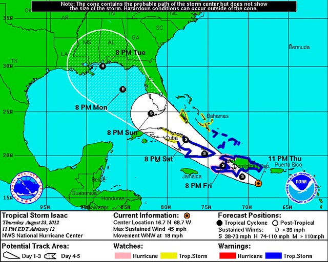
The westward shift is also reflected by the “spaghetti” computer model map. The models have almost uniformly shifted west, decreasing the threat to Tampa and the Republican National Convention — and increasing the threat to the central Gulf, including flood-prone Mobile Bay and über-vulnerable New Orleans, right around the seventh anniversary of Hurricane Katrina.
Mind you, Tampa and the RNC are not completely out of the woods yet. But, remembering that “the trend is your friend,” this is looking more and more like a potentialy Florida Panhandle or Alabama/Mississippi/Louisiana issue than a problem for Florida’s West Coast.
More broadly, the new track also means Isaac could be over water for 48 to 72 hours after popping off Cuba, instead of the 24 to 36 hours it’d have if it followed a more Tampa-bound track. That gives the storm much more time to “get its act together” after the imminent land interaction with Cuba and Hispaniola. Even if, after exiting Cuba, it takes a day or more for the storm’s inner core to become more structurally sound, this new track means there would still be ample time for rapid intensification over water once that process finishes. That, of course, would be bad news for wherever Isaac is headed, but most especially if New Orleans is the landfall target.
We should start to get a clearer idea of Isaac’s path tomorrow morning. NOAA and the Air Force have been throwing all sorts of equipment at the storm and its surrounding atmospheric environs today, trying to get the best data possible for the forecast models. In particular, the NOAA G-IV jet has completed a mission, and its data will be fed into the next set of computer models. So, with any luck, things will start to look a lot clearer overnight. Watch @RyanMaue for the latest computer model information as it comes in (the GFS and ECMWF are the most important), and check the NHC for the critical 5:00 AM EST advisory.


Join the conversation as a VIP Member