

First things first, the official 11:00 AM EDT forecast track:
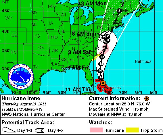
Remember, this is the National Hurricane Center’s interpretation of a bunch of computer models, some of which think Irene will go to the left, some to the right. Nobody knows for sure what the storm’s precise course will be. So don’t focus on the track line. Focus on the “cone.” If you’re inside it, assume you’ll be getting a direct hit from a hurricane of Category 2 strength of greater, with adverse effects starting 12 to 24 hours before the track “line” gets closest to you. Prepare accordingly. Start now. The end.
Okay… not quite “the end.” Before I get to the “misconceptions” referenced in the title of this post, I’m going to quote extensively from Dr. Jeff Masters, who has an excellent, thorough post this morning on the threat all up and down the coast:
Back in 1938, long before satellites, radar, the hurricane hunters, and the modern weather forecasting system, the great New England hurricane of 1938 roared northwards into Long Island, New York at 60 mph, pushing a 15-foot storm surge to the coast. Hundreds of Americans died in this greatest Northeast U.S. hurricane on record, the only Category 3 storm to hit the Northeast since the Great Hurricane of 1815. Since 1938, there have been a number of significant hurricanes in the Northeast–the Great Atlantic hurricane of 1944, Hazel of 1954, Diane of 1955, Donna of 1960, Gloria of 1985, Bob of 1991, and Floyd of 1999–but none of these were as formidable as the great 1938 storm. Today, we have a hurricane over the Bahamas–Hurricane Irene–that threatens to be the Northeast’s most dangerous storm since the 1938 hurricane. We’ve all been watching the computer models, which have been steadily moving their forecast tracks for Irene more to the east–first into Florida, then Georgia, then South Carolina, then North Carolina, then offshore of North Carolina–and it seemed that this storm would do what so many many storms have done in the past, brush the Outer Banks of North Carolina, then head out to sea. Irene will not do that. Irene will likely hit Eastern North Carolina, but the storm is going northwards after that, and may deliver an extremely destructive blow to the mid-Atlantic and New England states. I am most concerned about the storm surge danger to North Carolina, Virginia, Maryland, Delaware, New Jersey, New York, and the rest of the New England coast. Irene is capable of inundating portions of the coast under 10 – 15 feet of water, to the highest storm surge depths ever recorded. I strongly recommend that all residents of the mid-Atlantic and New England coast familiarize themselves with their storm surge risk. The best source of that information is the National Hurricane Center’s Interactive Storm Surge Risk Map, which allows one to pick a particular Category hurricane and zoom in to see the height above ground level a worst-case storm surge may go. If you prefer static images, use wunderground’s Storm Surge Inundation Maps. If these tools indicate you may be at risk, consult your local or state emergency management office to determine if you are in a hurricane evacuation zone. Mass evacuations of low-lying areas along the entire coast of New Jersey, Delaware, Maryland, and Virginia are at least 30% likely to be ordered by Saturday. The threat to the coasts of New York, Connecticut, Rhode Island, Massachusetts, New Hampshire, and Maine is less certain, but evacuations may be ordered in those states, as well. Irene is an extremely dangerous storm for an area that has no experience with hurricanes, and I strongly urge you to evacuate from the coast if an evacuation is ordered by local officials. My area of greatest concern is the coast from Ocean City, Maryland, to Atlantic City, New Jersey. It is possible that this stretch of coast will receive a direct hit from a slow-moving Category 2 hurricane hitting during the highest tide of the month, bringing a 10 – 15 foot storm surge. …
The models have edged their tracks westwards in the last cycle of runs, and there are no longer any models suggesting that Irene will miss hitting the U.S. The threat to eastern North Carolina has increased, with several of our top models now suggesting a landfall slightly west of the Outer Banks is likely, near Morehead City. After making landfall on the North Carolina coast Saturday afternoon or evening, Irene is likely to continue almost due north, bringing hurricane conditions to the entire mid-Atlantic coast, from North Carolina to Long Island, New York. This makes for a difficult forecast, since a slight change in Irene’s track will make a huge difference in where hurricane conditions will be felt. If Irene stays inland over eastern North Carolina, like the ECMWF and GFDL models are predicting, this will knock down the storm’s strength enough so that it may no longer be a hurricane once it reaches New Jersey. On the other hand, if Irene grazes the Outer Banks and continues northwards into New Jersey, like the GFS model is predicting, this could easily be a Category 2 hurricane for New Jersey and Category 1 hurricane for New York City. A more easterly track into Long Island would likely mean a Category 2 landfall there.
Category 2 landfalls may not sound that significant, since Hurricane Bob of 1991 made landfall over Rhode Island as a Category 2, and did only $1.5 billion in damage (1991 dollars), killing 17. But Irene is a far larger and more dangerous storm than Bob. The latest wind analysis from NOAA/HRD puts Irene’s storm surge danger at 4.8 on a scale of 0 to 6, equivalent to a borderline Category 3 or 4 hurricane’s storm surge. Bob had a much lower surge potential, due to its smaller size, and the fact it was moving at 32 mph when it hit land. Irene will be moving much slower, near 18 mph, which will give it more time to pile up a big storm surge. The slower motion also means Irene’s surge will last longer, and be more likely to be around during high tide. Sunday is a new moon, and tides will be at their highest levels of the month during Sunday night’s high tide cycle.
There’s lots and lots more good information in Masters’s post. I urge you to read the whole thing.
Now, on to the main substance of this post. From some comments on my previous post, tweets on Twitter, and even conversations with co-workers here in Denver, I get the sense that a number of misconceptions — some fairly benign but still frustratingly inaccurate, others downright dangerous — are floating out there regarding Irene. I’m going to try to clear some of them up. Here goes:
• Cool waters offshore will protect the Mid-Atlantic / New Jersey / New York / New England from a major hit. Not necessarily. The computer models and weather forecasters are well aware of the cooler water temps north of the Carolinas, and they already predict the storm will weaken as a result. So you shouldn’t view the forecasts and then mentally subtract a category or two off the storm because of the cold water — that effect is already factored in. The reason Irene might still be a Cat. 2, or even conceivably a Cat. 3, when it reaches New Jersey/NYC/Long Island/New England, is because it may get strong enough beforehand that it has a long way down from its peak, and takes a while to get there. Also, because it’s a geographically large storm, it will take longer to “wind down” and weaken. Moreover, even if the storm does weaken substantially as it approaches the northeast, it could (depending on its track) be pushing a big hulking wall of water ahead of it built up when it was stronger. That wall of water won’t instantly diminish when the storm’s winds do. So we could, for instance, see a Category 1 hurricane with a “Category 3” type surge (much like Katrina hit Mississippi as a Category 3 with a Category 5 surge, for the same reason).
 • Irene doesn’t look that bad; what’s the big deal? The hurricane doesn’t yet have the classic appearance of a monster storm on satellite, because she probably just went through, or is going through, an eyewall replacement cycle (the details are a bit murky at the moment). But it’s quite likely she will develop that classic appearance in the next 24 hours or so. When she does, people will suddenly start to panic, just as they did in 2005 when Hurricane Katrina developed overnight into a Category Five — precisely as had been predicted, yet many folks ignored those predictions until they could see the result with their own eyes. That’s foolish. The day to begin worrying, and more importantly, preparing, is not tomorrow. It’s today.
• These models are all over the place. The forecasters have no idea what they’re doing. Hurricane track forecasting has improved drastically in recent years. When I was a kid watching these storms, 3-day forecasts were hopelessly uncertain, and 5-day forecasts were a pipe dream. Now, the 5-day forecasts are where the 3-day forecasts used to be. The computer models have gotten better and better, and the human forecasters have gotten better at interpreting them. But this stuff is hard. It’s extremely complex — we’re talking about “modeling” the entire Earth’s atmosphere using equations, and then trying to pinpoint exact locations and times of short-period atmospheric events. (Leave your global warmings arguments at home here, please, both sides of the debate. Totally different type of modeling, totally different goals.) This is why the National Hurricane Center is very cautious, loads up its forecasts with caveats about uncertainties, and reminds everyone to focus on the track “cone,” not the track “line.” The responsible weathermen and reporters do the same. Some don’t, but that’s their fault, not the models’ or the hurricane forecasters’. Anyone who tells you they know exactly where this storm will go is lying. But that’s no excuse not to take the possibilities seriously, if you live in the “cone.”
• Irene is only a threat to coastal areas. Admittedly, I probably inadvertently contribute to this one; I tend not to focus as much as I should on inland flooding. But inland flooding is a big deal, a huge killer and property-destroyer, often causing more damage than the “sexier” coastal effects. It’s a particular threat in this instance because Irene is expected to move more slowly through the mid-Atlantic and northeast than most storms do at this latitude. And the ground in many places is already saturated. So it’s going to be a major, major, major rain event, and potentially a major flooding event. If you live in an area prone to river flooding or flash flooding, even well inland, be prepared!
• Irene is only a threat to the NYC area. My focus has been on NYC because of the unique nature of the threat there, and the number of people affected, but the primary threat zone may now be further south — not only North Carolina, which is looking more and more likely to get a severe direct hit, but the Virginia / Chesapeake / Maryland / Delmarva / Delaware / New Jersey stretch of the coast. Again, go read Dr. Masters’s post for more on that.
• New York City can’t possibly evacuate 8 million people! It’s already too late! They’re DOOMED! New York doesn’t need to evacuate 8 million people. It needs, potentially, if the track still looks like a threat this evening, to evacuate folks in low-lying areas, as defined by this evacuation-zone map. High-rise buildings, or at least certain types of high rises, are also a concern, because the winds are stronger as you go higher up, and the canyons of Manhattan could enhance the winds further. (I’m not a building engineer, so I can’t speak to which high-rise buildings are safe and which are not. I assume local officials and media will be on top of this.) But much of the city is safe from the water, and safe enough from the wind to hunker in place. The old saying goes: “Run from the water, hide from the wind.” If everyone tried to evacuate, all at once, it would be an unmitigated disaster, and the folks who actually need to get out, wouldn’t be able to. When I said the “‘Get the Hell Out’ moment” might be coming tonight, I meant for people in vulnerable areas, not for the entire city. New York isn’t New Orleans, the vast majority of which would have flooded in the worst case scenario (which Katrina actually was not). It was always understood that a major hurricane strike would turn New Orleans into a post-apocalyptic hellhole in the immediate aftermath, which is why I thought it was prudent for everyone, even on higher ground, to get out. The same is not likely true for New York — the aftermath would be bad and traumatic, but not like New Orleans. So, in terms of evacuation, listen to the local authorities and media, and to your common sense. But don’t panic. If you’re in a well-constructed building, well above sea level, there is likely no reason for you to leave.
• I, Brendan Loy, should be your primary source for information about this. I really shouldn’t. I’ll do my best to keep this blog updated — also check my Twitter feed — but unlike during Katrina, when I was a second-year law student who could basically take a week off from life to blog, I’ve got a full-time job, a wife and three kids now. And I live in Denver, Colorado — safely outside of the “cone.” :) So I’ll be following the storm closely from afar, but please don’t treat what I say as gospel. In particular, I get lots of questions that, while I’m happy to try my best to answer them if I can, would be better directed at local folks — government officials, civic leaders, local media, whomever — in your particular area with knowledge of the issues specific to that locale.
For updates on the storm itself, your primary source should be the National Hurricane Center, which publishes major updates, including new forecast tracks, at 5:00 and 11:00 EDT (AM and PM), and minor updates at 2:00 and 8:00 (again, AM and PM). For computer model graphics, I highly recommend Ryan Maue’s Twitter feed. (You can also check my feed, as I’ve been tweeting a lot of links to model images — including RTs of many of Ryan’s tweets.) For more detailed/technical model data, go here, or to Ryan’s excellent site here. Be very cautious, though, about putting too much stock in any one computer model. Trust the NHC and its track “cone” for guidance, as well as your local National Weather Service, local officials and media. As for images, you can view satellites here and, when the storm gets closer, radar here. Other good weatherbloggers to follow: Dr. Jeff Masters, Eric Berger and FLhurricane.com.
On with the misconceptions…
• I’m “predicting” a catastrophe. No, I’m not. I’m saying a catastrophe is possible. I told a friend last night that Irene might ultimately be remembered as anything from a mild inconvenience to a world-historical disaster. Most likely, it will be somewhere in between those two. We simply don’t know exactly what the storm will do, but there are some very bad scenarios which are plausible, and I’m focusing on those because, well, didn’t we learn in kindgergarten to “hope for the best, prepare for the worst”? Which brings me to my next (related) set of misconceptions…
• Because [Storm X] didn’t cause the predicted/feared destruction in [Location Y], Irene won’t either. This one is an absolute classic in the “misinformed statements about hurricanes” genre. Every single time a storm hits land, anywhere, some locals insist on some variation of this. It’s insanely frustrating for those of us who follow these storms, because it’s complete and utter nonsense. People don’t seem to understand that every hurricane is different, and their impacts can be drastically divergent for reasons that aren’t always obvious. For instance, 1985’s Hurricane Gloria not only stayed well east of New York City, it also hit Long Island at low tide, limiting the storm surge damage even at its ground zero. But, as should be obvious but seemingly isn’t, Gloria’s track 26 years ago provides us with zero evidence — none, nada, zilch — that Irene will do the same thing. Sure, Irene might stay east (or west) of NYC, and sure, it could come in at low tide. Or it could wallop NYC directly at high tide! We just don’t know yet, and it’s foolish and dangerous to presume that there’s some magical force in the ether that will ensure Irene is no worse than various randomly selected prior storms. Speaking of which, our next misconception…
• Irene will turn away from [Location Y] at the last possible moment. They always do that. This is another classic, and it, too, is complete bunk. Yes, hurricanes often make last-minute turns and wobbles, but there’s no iron law that requires them to always steer clear of utter disaster. The reason it might feel like hurricanes “usually” do this is because it generally takes a pretty precise “threading of the needle” to produce a worst-case scenario track; the majority of possible scenarios are not “worst-case.” So the odds are nearly always against a worst-case scenario, right up until the last possible moment. That means you’ve got to prepare for the worst case, even knowing it probably won’t happen, because if you wait until it’s likely (still less certain) to happen, it’s too late to prepare! Which is why our next misconception is so deeply wrong…
• If the worst-case scenario doesn’t happen, this was all a bunch of unwarranted hype. No, no, no, a thousand times no. As I just said, the worst-case scenario is never going to be likely at 2 or 3 or 4 days out, because NO individual scenario is “likely” at that point (there are always multiple plausible scenarios when landfall is days away), and the majority of scenarios are non-worst-case. So, at least 9 times out of 10, when you prepare for the worst, you’ll be pleasantly surprised as the worst doesn’t happen. And yet somehow, in every single one of those nine cases, some people feel justified in crowing about how the “experts were wrong again!” as they “overhyped another storm!” and local media figures and government officials were fools to make everyone unnecessarily prepare and/or evacuate. Some even start this crowing in advance, preemptively, arguing that it’s somehow irresponsible to emphasize a worst-case scenario (or even a second-worst or third-worst case) that’s a less than 50% shot to happen. This attitude betrays a complete misunderstanding of the situation. Imagine if someone told you there was a 10% chance of a devastating terrorist attack in your city in a few days. Would you take precautions? Would you consider altering your plans for the day in question, at least if those plans put you in a particularly vulnerable spot? Or would you simply ignore the threat altogether, because, hey, no worries, there’s a 90% chance it won’t happen! I submit that you’re a fool if you choose Option B, and I think few folks would pick that option. A ten percent chance of a devastating, potentially mass-casualty event is a very large chance, given the nature of the event. People seem to understand this with events like terrorist attacks, but for some reason, the same standard is not applied to weather, perhaps because many folks just don’t understand the uncertainties inherent in meteorology, and thus wrongly expect perfection from forecasters. Whatever the reason, this attitude is just wrong. Forecasters and media types should make clear that nothing is certain, and they should not “hype” the storm in the sense of being cartoonishly sensationalistic, but they are absolutely right to emphasize the severe nature of the worst-case threat, and people absolutely need to prepare as if the worst will happen.
P.S. To be clear… the “10 percent” number has no scientific basis, and does not refer to any particular scenario being 10% likely to happen. I’m just articulating the general concept that worst-case scenarios that are “unlikely” — but plausible, realistic, and far too likely for comfort — must be taken seriously, and prepared for as if they were definitely going to happen, even though that’s not the case. There’s really no other choice.


Join the conversation as a VIP Member