
[NOTE: check the blog homepage and follow me on Twitter for the latest all weekend.]
* * * * *
I find myself feeling a profound sense of déjà vu this evening. One day short of exactly seven years ago, on August 26, 2005, this post by weatherblogger Charles Fenwick about Hurricane Katrina — “Every global model plus the GFDL shifted its track to the west its forecast to the west in its 12Z run. Forecasts are now in a fairly tight cluster between eastern Louisana and Mississippi.” — led to my blog post that I’d eventually read aloud in a Spike Lee movie, “New Orleans in peril,” in which I wrote that an “unprecedented cataclysm” could be in the cards for America’s most hurricane-vulnerable city.
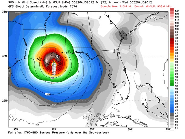
Something similar happened today. Around noon Eastern Time, the 12Z run of the GFS computer model — the model which had previously favored a more easterly track for Tropical Storm Isaac, with landfall consistently somewhere in Florida — showed a significant shift to the west, with a direct hit on Mobile, AL. It also showed intensification to a strong Category 3 hurricane en route to Louisiana — a “hell-storm scenario,” as Dr. Ryan Maue put it. Then the 18Z GFS run came out. It continued the westward shift, but now, the “hell-storm” was aiming at New Orleans. The trend has now continued with the newly released 00Z GFS, depicted above. With the right-front quadrant aiming at the Mississippi Delta, it’s pretty much a worst-case scenario for the Big Easy, short of a Category 4 or 5 on the same track. If that track were to verify, it would be an utter calamity. It might well be worse, meteorologically at least, than Katrina, which was of course primarily a man-made disaster caused by shoddy levees. (Katrina peaked at Category 5, yes, but she was Category 2 at landfall and Category 1 in New Orleans, and her epic, Cat. 5-esque storm surge primarily hit Mississippi, not Louisiana.)
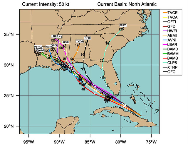
That doesn’t mean the 00Z GFS is necessarily going to happen. Not by a long shot. We’re talking about a 72-hour forecast by a single model. Its details can and will change. But other models have followed suit, and the “consensus,” at present, does seem to be around a landfall in the same region targeted by Katrina:
Back on August 26, 2005, the sudden westward shift in the models was not immediately acknowledged by the National Hurricane Center, which consciously avoids “chasing” the latest hot computer model trend, precisely because models so often reverse themselves, and the NHC doesn’t want its official track ping-ponging around wildly. So they generally wait for confirmation from additional models, and additional model runs, before buying into a new track reasoning. Thus, as I recall, the NHC forecast track shifted west from the Florida panhandle to Mobile, Alabama at 5:00 PM — splitting the difference between the “old” and “new” forecasts — and completed the shift at 11:00 PM, pointing a beeline at the New Orleans area that would remain basically unchanged for the next three days.
The NHC did something similar tonight in its 11:00 PM discussion, stating: “THE UPDATED TRACK IS VERY CLOSE TO THE PREVIOUS ADVISORY THROUGH 36 HOURS. AFTER THAT TIME…THE TRACK HAS BEEN ADJUSTED WESTWARD…BUT IT REMAINS EAST OF THE DYNAMICAL MODEL CONSENSUS TO RETAIN SOME CONTINUITY WITH THE PREVIOUS FORECAST.” In other words, if things continue as they are, the new “consensus” would mandate pushing the track further west. But the NHC is going to wait and see.
(In fairness to the NHC, they also express some substantive reason to question the forecast of the GFS, basically portraying it as falling into one of two camps about what Isaac will do. More on that later.)
Thinking back to that Friday in August 2005 again, it was apparent to weather buffs all day long what was happening with Katrina — that New Orleans, not Florida or Alabama, was now the real issue. Yet the lazy media stuck with its prefabricated storyline: Florida, which had been hit by 6 hurricanes in the preceding 14 months, was at risk again! This time around, the prefabricated storyline is the Republican National Convention, but the result is the same: all the attention remains on Florida, even as New Orleans has become the bigger story.

Even the local newspaper does not seem to realize yet, judging by its website’s story selection and placement, that New Orleans could have a major problem on its hands:

And so, yeah. It feels like August 26, 2005 — a defining day of my decade — all over again.
There are some key differences, though. First and foremost, as Maue notes, there’s a lot more uncertainty this time around. On that night in 2005, aside from generic statements about the inherent vagaries of forecasting, there wasn’t really any specific reason to disbelieve that Katrina would move along the projected path toward doomsday for New Orleans. With Isaac, that’s not the case. The steering patterns guiding Isaac are complex and, in the case of the GFS scenario, are expected to become weak closer to the end of the forecast period, which is always a recipe for an uncertain forecast. (With Katrina, the steering currents were strong and easy to identify, which is why the forecast was so accurate.) Also, the computer models, although they are scientifically much improved since 2005, have yet to demonstrate that they have a good handle on Isaac in particular. Isaac itself is still getting its act together after crossing Hispaniola and Cuba (whereas Katrina barely weakened at all in its passage over Florida the night before), which both makes the track forecast harder and the predicted intensity blowup harder to fully embrace.
Another difference is the likely intensity. Katrina, as I mentioned, was already well-formed when it popped off south Florida into the Gulf, so there was nothing to slow its intensification. It was also already a hurricane. Isaac has yet to become a hurricane, and has thus far failed to realize its potential even when computer models have called for significant intensification at earlier stages. Thus, there’s a certain “I’ll believe it when I see it” quality to these forecasts. That wasn’t really present with Katrina. In Katrina’s case, it was obvious, given the bathtub-like waters of the Gulf of Mexico, and in particular the “heat content” (which factors in the depth of the warm water, which is critical for rapid intensification), that putting a hurricane in that Gulf would be like throwing gasoline on a fire — rapid deepening to a monster storm was pretty much inevitable. With Isaac, while a number of models are predicting rapid deepening, it’s harder to understand why, both for the reasons just stated and because the heat content is mediocre in much of the Gulf. That means, HWRF model notwithstanding, I suspect Isaac’s ceiling is probably closer to Category 3 than Category 5.
Yet another difference is the insane anticipation as we await — in the next 45 minutes or so — the latest forecast from the ECWMF (Euro) model, which hasn’t weighed in since midday, before all these massive track shifts started happening. The Euro, which I don’t even think was considered a reliable hurricane model at all in 2005, has become the most accurate model in existence, outpacing even the GFS, so everyone is waiting with bated breath to see if it agrees with the GFS. I can’t ever recall such anticipation for a single model run. We’ll find out what the Euro thinks within the hour, and the answer will clearly have a great deal of impact on the NHC’s thinking, judging from the 11:00 PM discussion:
IN ABOUT 48 HOURS…ISAAC WILL BE NEARING THE WESTERN PORTION OF THE RIDGE AND SHOULD MOVE IN A GENERAL NORTHWESTWARD HEADING OVER THE EASTERN GULF OF MEXICO…BUT LARGE DIFFERENCES EXIST BETWEEN THE LATEST ECMWF AND GFS MODELS AFTER THAT TIME. THE ECMWF RECURVES ISAAC AHEAD OF A MID-LATITUDE TROUGH OVER THE EASTERN UNITED STATES…WHILE THE GFS SLOWS ISAAC DOWN AS THE TROUGH BYPASSES THE SYSTEM AND THE MODEL THEN TURNS THE CYCLONE WESTWARD TO THE SOUTH OF A DEVELOPING MID- TO UPPER-LEVEL RIDGE. THIS BIFURCATION IS ALSO SEEN IN THE MOST RECENT ECMWF AND GFS ENSEMBLES WITH ABOUT AN EQUAL NUMBER OF MEMBERS SHOWING RECURVATURE VERSUS A CONTINUE NORTHWESTERLY TRACK TOWARD THE NORTHERN GULF COAST.
If the Euro changes course and agrees with the GFS, we’ll be looking at a fairly high-confidence Louisiana-aimed forecast in the 5:00 AM advisory, I would imagine. If not, the uncertainty would persist.
Either way, I would think that Mayor Mitch Landrieu will need to make decisions tomorrow about evacuation. Ray Nagin foolishly waited until 24 hours before Katrina to order mandatory evacuations, but all the studies and reports I read, pre-Katrina, indicated that it would take 48 to 72 hours to fully evacuate the city. By midday Sunday, we’ll be looking at 48 hours until conditions begin to deterioriate ahead of a late-Tuesday or early-Wednesday landfall. So tomorrow will be a very, very important day in many respects.
(By the way, my focus on New Orleans doesn’t imply that it’s the only likely, or most likely, landfall target, nor that it’s the only place that matters. It’s just that the potential consequences of a direct hit on New Orleans are so much more dire than elsewhere, it automatically becomes the central focus of attention anytime it’s a realistic possibility.)
I’ll try to post something else briefly after the European model comes out within the hour.


Join the conversation as a VIP Member