
Let’s get this out of the way first: There’s nothing funny about Australia’s wildfire season. People are dead or homeless, millions upon millions of animals have been killed, and everything is just awful.
But we must also say this: ABC News is so stupid it’s funny.
This a story so dumb and wrong that it’s unthinkable that the American network’s news division hasn’t deleted or corrected it — and yet as I write these words, it still stands for all to see and mock.

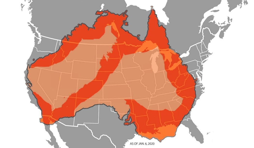
(This is a screencap in case someone at ABC News finally wakes up and does their damn job.)
ZOMG! A THIRD OF AUSTRALIA is on FIRE!
ABC’s Matt Zarrell, apparently stupid, shameless, or both, wrote a whole story (with help from three more reporters — Samara Lynn, Christine Theodorou, and Maggie Rulli — not one of whom apparently knows any better) using this fake map.
I want you to read from that report these two paragraphs republished here exactly as they appear at the ABC News website:
The size of the fires across the country are twice as large as the state of Maryland and bigger than several other states, including Vermont, New Hampshire, Massachusetts and New Jersey.
A superimposed map of Australia over the United States shows the scale of the regions affected by the massive wildfires that have spread Down Under.
I live in Colorado, and Vermont, New Hampshire, Massachusetts, and New Jersey are what we westerners call “tiny little states.” Tiny little states that in no way, not even when doubled in size, cover anything close to the area indicated by the superimposed map. So you literally cannot put those two paragraphs — one claiming something like a third of a big continent is on fire, the other stating (correctly) that the fire is about twice the size of Vermont — in the same story, one after the other, without looking like a total idiot.
But readers will remember the scary (but wrong) map much better than they’ll remember the not-so-scary (but correct) words.
Here’s a better and much more accurate representation of the fires, courtesy of Alexei T on Twitter:

To be clear: Those are bad fires. They’re huge and they’re killing people. But they’re not a third of Australia, either. A third of Australia isn’t even “affected” by the fires, whatever that means, and which the ABC News report never explained.
So where’d the map come from?
According to Alexei, ABC News editor Matt Zarrell “Appears [to have] used Himawari-8 🛰️ thermal anomalies (‘hotspots’) from Jan 2 … so anything hot (cars in full sun, industry)+ fire used in land mgmt.” In other words, that’s not a map of stuff on fire, but a map of virtually anything in Australia that gets hot enough in direct sunlight to get picked up by a very sensitive Japanese weather satellite. Layers of editors and fact-checkers or whatevs.
The replies on Twitter at least have at least been spot-on — and enjoyably so.


Why indeed?
Three more questions: How did ABC News editor Matt Zarrell ever think for one moment that a third of Australia was on fire? How did three other reporters get their names on something so wrong? How has no one (as of this writing) at ABC News deleted or corrected this mess?
Although I suspect the answer to all four questions is the same: ABC “News” is in the business of pushing narratives, rather than reporting actual news.
Unless you have a better explanation?


Join the conversation as a VIP Member