

[NOTE: Follow me on Twitter for the very latest on Isaac.]
* * * * *
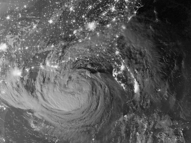
Before we get into the ugliness of conditions in Louisiana and Mississippi right now, let’s start with something beautiful — a NASA image of a moonlit Tropical Storm Isaac early Tuesday as it approached the Gulf coast:
On to the ugliness. Isaac — now a tropical storm again as it gradually weakens over land — has sloooooooowly crawled northwestward through Louisiana all day, taking 28 hours and counting to complete the journey from the mouth of Mississippi River in Plaquemines Parish to the city of Baton Rouge, which takes 3 hours by car.
Along the way, Isaac has dumped relentless rains — Audubon Park in New Orleans recorded an incredible 19.30″ of rain, 18.70″ of it within a 24-hour period — and pummeled the region with seemingly endless wind and surge. The vast bulk of southeastern Louisiana is without power, and people are stuck in their homes with nothing to do but watch and wait for the storm to finally move out of the area. Listening to WWL radio today, the overwhelming sentiment was simply frustration that the storm wouldn’t get gone.
New Orleans proper appears to have done quite well, as the levees have remained intact and the pumps have worked as planned, both passing their biggest test since Hurricane Katrina. But to the south in Plaquemines Parish, the locally constructed levee did not fare so well. Massive flooding created scenes of devastation that locals, including local officials, described as worse than anything they suffered in Katrina — a symptom of Isaac’s worst-case track, angle of approach, and horrifically slow movement trumping its comparatively lower intensity. The images from Plaquemines are heartbreaking:


Those pictures are, to my mind, a helpful reminder of what the true “worst-case scenario” for New Orleans — which Katrina emphatically was not — would look like, but across a much broader area. As opposed to being trapped in attics or on rooftops hours after the storm, folks are trapped and threatened while the storm is still raging. As opposed to a slow leak, caused by breached levees, which gradually fills the “bowl” to regular sea level (finishing long after the storm leaves), what Plaquemines Parish is experiencing is a rapid, in-storm flash-surge-flood caused by overtopping of the levees, which fills the “bowl” up to, in essence, the level of the storm surge at or near its peak, and then leaves the water there, hemmed in by the very levees that were originally there to keep it out. For this reason, officials are considering deliberately blowing holes in the levees to assist with drainage. That is precisely the sort of scenario envisioned in the pre-Katrina literature about the worst-case possibilities for New Orleans. In NOLA’s case, it would take a Category 3 or 4 storm to do it, but someday it will happen. Folks need to understand that, and not treat “Katrina” as synonymous with “The Worst Thing That Can Possibly Happen,” because that just isn’t so.
Plaquemines’ situation is also an object lesson in why, when authorities order you to evacuate, you evacuate. You don’t sit there and carp about “hype” and “hysteria,” and about how “it’s just a tropical storm” or “it’s just a Category 1” or “we survived [insert previous storm here], we’ll be fine.” You don’t make up your own amateur weather forecast, in contradiction to the actual experts, based on gut instinct and life experience, and then make life-or-death decisions based on that self-forecast. No. You know what you do? YOU LEAVE. If you’re in a low-lying area vulnerable to surge flooding and the authorities tell you an evacuation is necessary, you get the Hell out of dodge. Period.
The people who stayed behind, despite mandatory evacuation orders, and then ended up predictably needing to be rescued, are endangering not only their own lives, but also the lives of the heroes — first responders, yes, but regular private citizens too — who came to their rescue. That’s inexcusable. However, I’m not saying this to berate them; they’ve suffered enough, and have undoubtedly learned their lesson. I’m saying it to the next group of people who might be tempted to do the same thing when the next storm threatens. Don’t. Do. It.
The disaster in Plaquemines occurred because of storm surge, which was almost as bad as Katrina’s for the area — not surprising, considering that Katrina, although more intense with a much bigger surge, made landfall to the east and kept its right-front quadrant away. This storm took a worst-case track, as I keep saying, and only its relative weakness spared the region a much more widespread catastrophe. Can you imagine if Isaac had managed to spin up to a Category 3, and then had done this? Good lord. Thank God for dry air.
Over in Mississippi, Biloxi was hit hard by flooding too, with the mayor confessing he wishes now he had ordered a mandatory evacuation. “I really didn’t anticipate this,” Mayor A.J. Holloway told The New York Times. “There’s a lot more water than I would have thought.” That attitude appears to be common among elected officials in several of the harder-hit areas, and I find it extremely irritating: Isaac’s effects should not have surprised anyone, as they were largely predicted in advance. Anyone who “didn’t anticipate this” was either not paying attention, was ignoring the worst case in favor of more desirable scenarios, or was disregarding the forecast in favor of their own instinct about what a Tropical Storm or Category 1 was likely to be capable of. Not a good plan.
Flooding has also occurred along Lake Pontchartrain, where the combination of storm surge and drenching rain has flooded various communities and subdivisions to varying degrees of severity. That appears to be improving now, but watch out for river flooding as the incredible rainfall totals work their way into the tributaries. This storm isn’t over yet. The National Hurricane Center predicts that it will take about another day to exit Louisiana completely. Ugh. Get the Hell out, Isaac!
Again, for the latest news on conditions in and around New Orleans, check NOLA.com and the local TV station websites. Here are the links to their livestreams:
Another great resource is the awesome WWL radio, which did amazing work during Hurricane Katrina and is doing so again. For Mississippi, check the Sun-Herald; for Baton Rouge, The Advocate.


Join the conversation as a VIP Member