

[NOTE: check the blog homepage and follow me on Twitter for the very latest.]
* * * * *
Isaac remains a tropical storm this morning, still suffering some of the inner core disorganization that has plagued it for days. And while the odds of a direct hit, or near-direct hit, on the New Orleans area are increasing, the odds of a “worst-case scenario” appear to be decreasing, as both the computer models and the official NHC forecast have downgraded their intensity forecasts a bit. Officially, the NHC is now calling for a Category 1 strike, although Category 2 remains very much in play. Category 3+? Still definitely possible, but probably a bit less likely than yesterday.
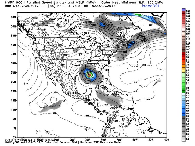
It’s still way too early for New Orleanians or others in Isaac’s path to let down their guard, though. Intensity is unpredictable, and at least one of the better models, the HWRF, is still calling for major hurricane at landfall:
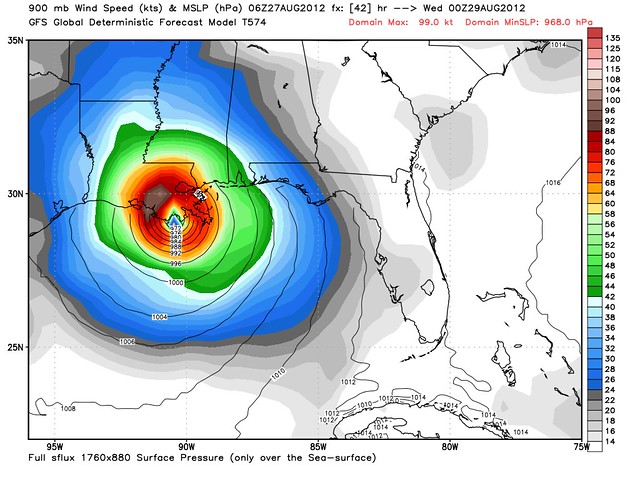
But the most accurate (on average) American model, the GFS — which has been driving the grave concern for New Orleans since Saturday afternoon, when it began predicting a Category 3 or 4 landfall there — is now calling for a somewhat less fearsome-looking Isaac, albeit still a low-end Cat. 3, coming in just west of the Mouth of the Mississippi River:
That scenario would still drive a ton of water into the New Orleans area, especially with the amount of time Isaac will have over the Gulf to push the Gulf waters toward shore ahead of landfall. Perhaps just as important, the possibility of rapid deepening remains frighteningly present, if Isaac could ever manage to get its inner core issues worked out. If that were to happen, say, 12 or 18 hours before landfall, it’d be really, really bad news. That’s why folks in harm’s way should continue to prepare for the worst.
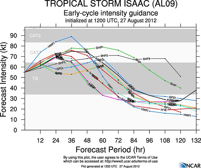
Still, there is increasingly reason to hope that Isaac will be something less than worst-case. Indeed, most of the intensity models don’t foresee it getting stronger than Category 1:
If the Cat. 1 scenario verifies, that’d be great news (though the surge would still potentially be a big problem, due to the storm’s size and duration). But it would also bring out the cries of “OVERHYPE!!!1!” in force, from folks contending myopically that the entire threat of something worse than Cat. 1 was dreamed up in the fevered imaginations of TV pundits and weatherbloggers. People who are tempted to make this argument would do well to remember what the computer model forecasts looked like Saturday afternoon, and Saturday night, and much of Sunday. I would suggest that those individuals take their unimpeachable 20-20 hindsight and go place a bet on the winner of last year’s Kentucky Derby. Weather forecasting is a difficult and inherently uncertain endeavor, and just because a scenario doesn’t occur, doesn’t mean it wasn’t a realistic concern at the time. If the phrase “prepare for the worst” means anything at all, it makes no sense whatsoever to argue that every worst-case scenario which doesn’t verify was therefore some sort of fraud. Most worst-case scenarios don’t happen. That’s in their nature. But since we don’t know in advance which ones will happen and which won’t, we still have to prepare for each one, in order to ready for the small percentage of them that do happen.
But I’m getting ahead of myself. Isaac remains a real, live threat to life and property, in the here and now. The odds of a total disaster may have dropped somewhat. But there is still plenty of reason to be concerned, especially about the biggest killer, storm surge — and folks in the storm’s path, particularly in New Orleans, need to continue to take it very, very seriously, and prepare accordingly.


Join the conversation as a VIP Member