

[NOTE: check the blog homepage and follow me on Twitter for the very latest.]
* * * * *
The official National Hurricane Center forecast as of 11:00 PM EDT calls for a near-worst-case track for New Orleans: a direct hit from the southeast.
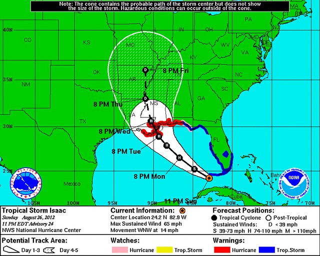
The predicted intensity, 100 mph (Category 2) at landfall, isn’t “worst-case,” though it’s not a walk in the park, either. But there’s a good deal of “downside risk,” if you will, that the intensity could be substantially more severe — possibly due to late, pre-landfall intensification, which is the worst kind (both for preparedness reasons and because, holding their stated intensity constant, intensifying storms are more dynamic and more damaging).
A Category 2 hurricane following the above track would be bad enough. A Category 3 or greater hurricane following the above track would be an absolute disaster.
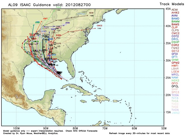
That said, this official track isn’t some sort of gospel truth. The computer models remain decidedly split, with some taking the storm well west of New Orleans, and some well east of it:
New Orleans is the NHC’s landfall point basically because it’s the midpoint of this uneasy model non-consensus right now. But it’s entirely possible that either the western “camp” or the eastern “camp” will be proven right, largely sparing the Big Easy. (New Orleans would prefer an error to the east vis a vis the NHC track. An error to the west would have to be quite substantial to be helpful, since the right-front quadrant is the most dangerous part of the storm, and would bring a massive surge into the NOLA area even if the storm’s center were a ways off to the west.)
Here’s how the 11pm discussion describes the track thinking:
THE MODELS SHOW ISAAC TURNING TOWARD THE NORTHWEST INTO A BREAK IN THE SUBTROPICAL RIDGE. ALTHOUGH THE MODELS AGREE ON THIS TURN…THERE IS AN UNUSUALLY LARGE SPREAD IN THE TRACK GUIDANCE AFTER 24 HOURS. THE SPREAD OF LANDFALL LOCATIONS ALONG THE NORTHERN GULF COAST RANGES FROM THE TEXAS/LOUISIANA BORDER EASTWARD TO THE ALABAMA/FLORIDA BORDER WITH THE HWRF…GFDL…AND GFS NEAR THE WESTERN EDGE AND THE UKMET AND ECMWF ALONG THE EASTERN EDGE OF THE ENVELOPE. OVERALL…THE CONSENSUS HAS SHIFTED A LITTLE WESTWARD AND THE OFFICIAL FORECAST AS BEEN MOVED IN THAT DIRECTION. THE NHC FORECAST IS BETWEEN THE ECMWF AND GFS ENSEMBLE MEANS AND NEAR THE HFIP MULTI-MODEL CONSENSUS. BECAUSE OF THE VERY LARGE SPREAD IN THE GUIDANCE…THERE CONTINUES TO BE GREATER THAN USUAL TRACK FORECAST UNCERTAINTY.
The next big event in the evolution of the track forecast will be the release of the 00z GFS around midnight EDT. Less important but still worth watching: the 00z HWRF and GFDL, around 1:30 and 1:45 AM EDT, respectively. Finally, the big one: the ECWMF (Euro) at around 2:10 AM EDT. (Links will cease being broken when the models go live.) If the twice-daily Euro shifts west toward the other models, the NHC’s hair will be on fire about New Orleans by the 5am advisory. If not, we’re probably looking at 12 more excruciating hours of track uncertainty.
The uncertainty can’t go on much longer, though. The divergent model tracks “split” within the next 24 hours. At some point Monday, Isaac will have to choose which way to go. Still, it would be nice to have a clearer idea by morning, so government officials and residents in New Orleans — and elsewhere — can make well-informed decisions first thing. (It would also be nice if Isaac would go ahead and strengthen to a hurricane. It’s psychologically difficult, I think, for people to take a “Tropical Storm” seriously. Isaac being upgraded is just a matter of time, so I think the sooner the better at this point, for the sake of preparedness.)
On the bright side, Isaac’s slight slowdown today has bought them a little more time. This is now looking more like a Wednesday event, rather than a Tuesday-night event, except maybe in Plaquemines Parish. Of course, conversely, a slowdown also potentially means more time to strengthen over the Gulf.
Speaking of which… what about intensity? On satellite, Isaac looks better organized tonight…
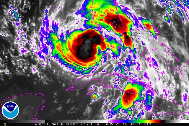
…but the strongest thunderstorms remain displaced from the center due to dry air on the storm’s south side. The pressure actually went up a millibar since the last advisory, though weatherblogger and author Mike Smith is skeptical: “The latest Hurricane Hunter aircraft was not able to get the dropsonde instrument exactly where it needed to be. It showed a slight rise in pressure, but that seems doubtful to me as the ‘central dense overcast’ for Isaac — a necessary component of a hurricane — now seems to be developing.”
On Twitter, Joe Bastardi mused that the center may re-form under the convection — which, it strikes me, would have big implications for the track, too, shifting everything to the right because of the center re-forming to the north. It would basically turn those LA/TX models into NOLA models, and the MS/AL models into Florida panhandle models (roughly speaking). But now I’m speculating. The NHC hasn’t said anything about center re-formation.
There’s also the fact that Isaac is a large system, so it can take a longer time to “wind up,” see pressure drops and eventually wind speed increases. One theory is that this process has begun, but is simply going to take a while because of the size of Isaac’s wind field.
Anyway, back to the dry air from the cut-off low southwest of Isaac. The computer models have been expecting that to abate for a while now, and yet it hasn’t, so who knows? Maybe Isaac will continue to be held back. We can hope. Here’s what the NHC writes about the intensity forecast:
THE LARGE SCALE ENVIRONMENTAL FACTORS…WARM WATERS…AND A CONDUCIVE UPPER-AIR PATTERN FAVOR STRENGTHENING DURING THE NEXT COUPLE OF DAYS. HOWEVER…THE LACK OF AN INNER CORE AND LARGE WIND FIELD COULD CONTINUE TO BE IMPEDING FACTORS FOR SIGNIFICANT STRENGTHENING IN THE SHORT TERM. THE NHC INTENSITY FORECAST SHOWS A GRADUAL INCREASE IN WIND SPEED DURING THE NEXT 12 HOURS OR SO…FOLLOWED BY MORE STEADY STRENGTHENING.
The bottom line is that Isaac may strengthen into a major hurricane, or it may continue to struggle a bit. As with the track, NHC basically splits the difference between these two scenarios. So don’t be fooled by the 100 mph peak forecast — it could get worse than that. (Or it could be a Cat. 1.) We just have to keep watching and waiting. Folks in the storm’s path should assume the worst, which would be a major hurricane.


Join the conversation as a VIP Member