

[NOTE: check the blog homepage and follow me on Twitter for the latest all weekend.]
* * * * *
So much for computer model consensus.
Last night, I wrote that, after days of warring over Tropical Storm Isaac’s track, the two most important and reliable computer models — the American “GFS” and the European “ECMWF” (or “Euro”) — had seemingly reached a consensus about where the storm is headed. The GFS, which had previously predicted a more easterly or rightward track, and the Euro, which had previously predicted a more westerly or leftward track, agreed in their “00Z” runs that Isaac would make landfall near Fort Walton Beach, Florida.
I wrote that the models’ newfound agreement “could prove to be an important development.” I added, however, that “we’ll have to wait 12 hours to see if this new consensus remains intact, or if the models diverge again.”
Well, it’s now 12 hours later, and survey says… no consensus. In fact, the GFS and the Euro have switched places. Suddenly the Europeans are the “righties,” while the GFS “leans left.” They never reached a consensus at all — they were just two ships passing in the night.
The Euro now favors a more easterly landfall on Florida’s Big Bend, while the GFS is predicting a scenario that would be quite disastrous if it happened: a 125 mph Category 3 hurricane making a direct hit on storm surge-prone Mobile, Alabama:
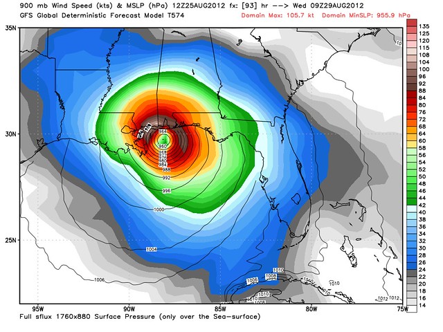
To be clear, that scary-looking GFS forecast is nothing to #PANIC about. It’s just one “run,” of one computer model, four days before predicted landfall. The GFS’s 18Z run will probably say something different, to say nothing of the 00Z runs, other models’ runs, tomorrow’s runs, etc. There’s a reason the National Hurricane Center is conservative about “chasing” the latest model runs with its official forecasts: they don’t want to give people whiplash as the track swerves back and forth. Only when you see “run to run” consistency within a model’s successive forecasts, and consensus among the various reliable models, do you begin to gain more confidence that a predicted track is likely to occur.
We’re just not at that point yet with Isaac. I thought last night, when I saw the GFS and Euro converging, that we might be getting there, but it’s clear now that we’re not. It may take until the storm is definitively finished with its passage over Cuba, or maybe even later than that, before we can get a clearer idea of where this thing is going. It will certainly take a bit longer before we have a good sense of how strong it’s going to get. (GFS thinks strong Category 3; Euro thinks borderline Cat. 1-2.)
To give you an idea of how divergent the models are, not only is the GFS aiming Isaac at Mobile while the Euro points it almost at Tallahassee, but another pretty good model, the HWRF, still thinks Isaac will be a big problem for Tampa:
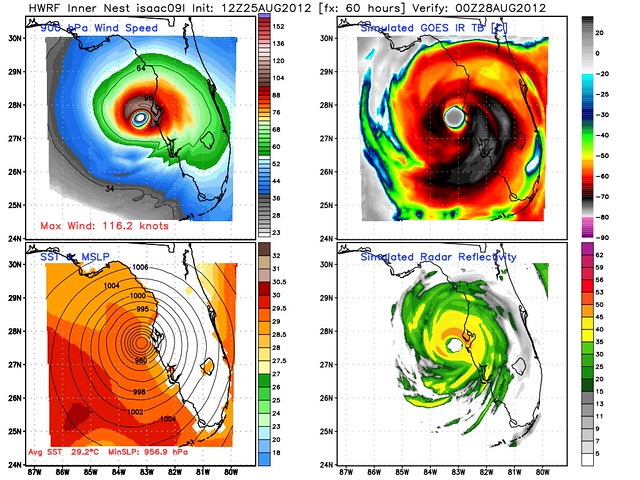
Now, I want to emphasize again, DON’T #PANIC, Tampa/RNC folks. In particular with regard to this Tampa map, the intensity forecast is very likely overdone; the HRWF has a tendency to do that. From a common-sense perspective, it seems highly unlikely, given the eastern Gulf’s decent-but-not-spectacular oceanic heat content, that Isaac would strengthen that much — to a Category 4! — if it were Tampa-bound. Limited time over water, post-Cuba, and proximity to land in Florida make such a scenario seem like a stretch.
The point is, though, that the computer models aren’t remotely in agreement yet. Some still think southeastern Louisiana is in play; others, as you can see, still see a threat to Tampa. To give you a further idea of the range, take a look at this graphic showing the conclusions of 20 different “GFS ensemble” models:
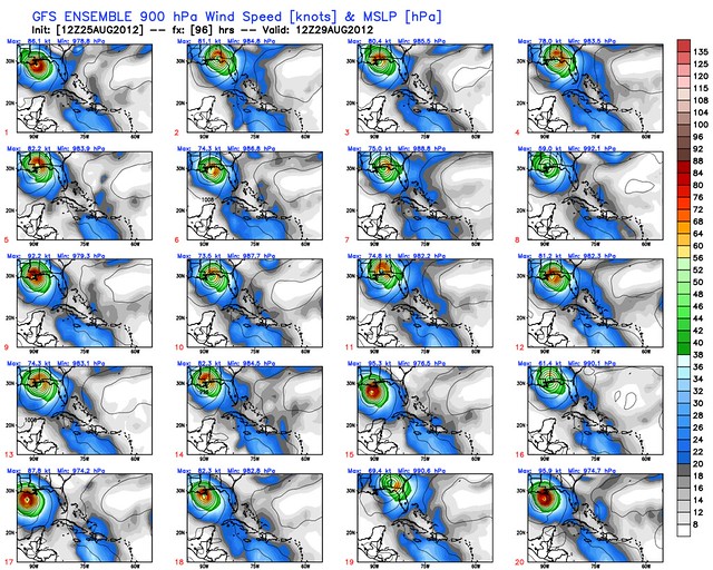
As you can see, the landfall points are all over the map, literally. As are the intensities.
For those of us who are “weather nerds,” things like the daily GFS vs. Euro battle are high drama; we can’t resist chasing down the latest computer model runs and trends. And, to be sure, those trends can yield valuable information at times. But at other times, the wildly vacillating back-and-forth of the models serves mostly as a helpful reminder of why the NHC is conservative about these things — and why, at season’s end, the NHC forecast performs better on average than any of the individual models.
So, stay tuned, here and on Twitter, where I tweet and retweet a lot about computer models. But don’t be fooled. A single computer model forecast shouldn’t cause you to either #PANIC or let your guard down. When a consensus finally develops and becomes clear, we’ll know — and the NHC forecast will follow it. In the mean time, we’ve just got to keep watching. And, if you live anywhere along the Gulf Coast from Louisiana to the Florida Keys, preparing.
(All model maps from Dr. Ryan Maue‘s Weather Bell Models; republished with permission.)


Join the conversation as a VIP Member