

[First, a PSA: check the blog homepage and follow me on Twitter for the latest all weekend.]
Another quick update before I go to bed, as a significant development has happened in the last few minutes.
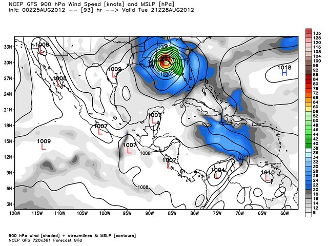
First, a bit of background: the two most reliable computer models are the GFS, run by the National Weather Service, and the ECMWF, more commonly known as the “European” model or simply the “Euro.” (This can be a little confusing for those who follow geopolitics — the Euro is reliable?)
Well, one of the reasons for the forecast uncertainty surrounding Isaac is that the GFS and the Euro have been at war for days, with the GFS suggesting a more easterly or rightward track, and the Euro suggesting more westerly or leftward track. (Typical lefty Europeans! Heh.)
But, in what could prove to be an important development, the 00z runs of the GFS and the Euro are now in good agreement. GFS has Isaac making landfall as a Category 3 (around 120 mph), while the Euro, which just came out, pegs it as a Category 2 (around 108 mph). But what’s more important is the track. Both models now have Isaac coming ashore around the Fort Walton Beach, FL area.
I already showed you the GFS landfall forecast:
Well, here’s the Euro forecast, which just came out:
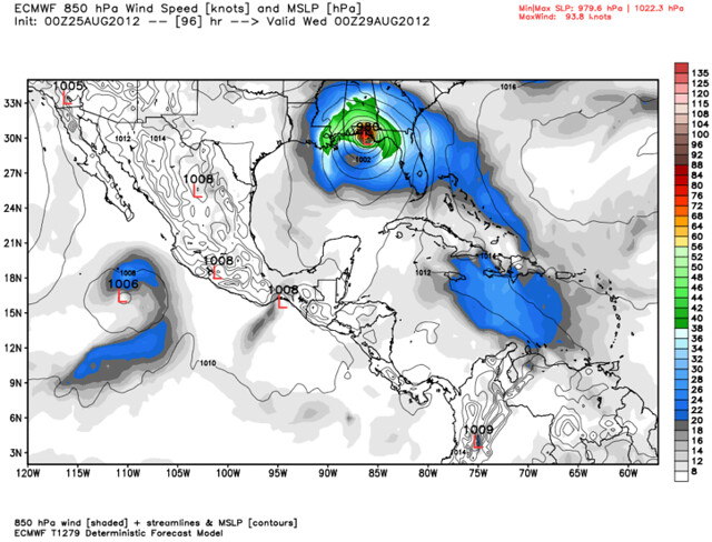
(Both maps courtesy of Weather Bell Models.)
The Euro is a twice-a-day model, unlike the four-times-a-day GFS, so we’ll have to wait 12 hours to see if this new consensus remains intact, or if the models diverge again. But for now, this at least tends to suggest a greater confidence in Isaac’s track. I suspect the National Hurricane Center will say something to that effect in its 5am EDT discussion (but I’m not going to stay up for that — you can check here).
This isn’t over yet — we’re still talking about almost a 4-day forecast, so errors are very, very possible — but folks in the western Florida Panhandle really need to start preparing; this hurricane is looking more and more like it’s probably going to be yours.


Join the conversation as a VIP Member