

[LATE WEDNESDAY UPDATE: Here’s my latest post.. Or just go to the Weather Nerd homepage.]
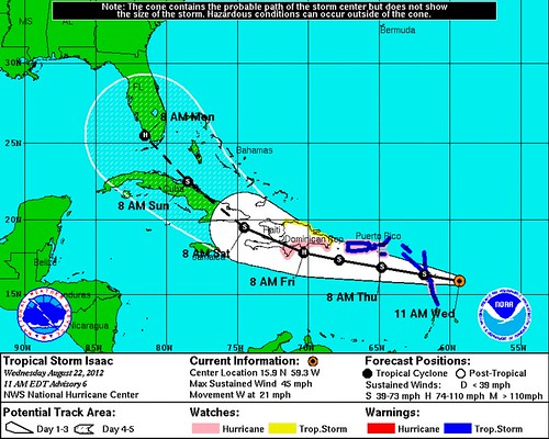
Let me begin with the standard caveats about uncertainty. 5-day track forecasts from the National Hurricane Center, while steadily improving year by year, still have an average error of around 250 miles. (That means, of course, that sometimes they’re even more wrong than that.) 5-day intensity forecasts are even shakier. That said, take a look at where the NHC believes a Category 1 hurricane named Isaac will be next Monday, which happens to be the first day of the Republican National Convention in Tampa, Florida:
Yikes.
Isaac is presently a Tropical Storm with winds of 45 miles per hour, and its inner core actually seems to have weakened overnight. But “the overall structure of the storm is improving,” according to the NHC’s 11am EDT discussion, which suggests its long-term prospects may be improving.
But with Tampa on everyone’s mind, the focus is on the track. The NHC sounds pretty confident about the first 48-72 hours of the forecast, bringing the storm into or near Hispaniola. After that, despite the relative consistency of the NHC forecast tracks since Isaac formed yesterday morning, there is more uncertainty — indeed, an increasing amount of uncertainty this morning, according to the NHC:
AFTER [48-72 HOURS]…THE [RIDGE OF UPPER-LEVEL HIGH PRESSURE SITTING ACROSS FLORIDA AND THE SOUTHEASTERN U.S. TO ISAAC’S NORTH] IS EXPECTED TO WEAKEN SOMEWHAT AS A MID/UPPER-LEVEL TROUGH MOVES ONTO THE EASTERN UNITED STATES. THE MODELS DIVERGE ON THEIR FORECASTS OF THE RIDGE. THE ECMWF [EUROPEAN COMPUTER MODEL] DOES NOT BREAK THE RIDGE…AND THUS FORECASTS A MORE WESTWARD MOTION NEAR OR SOUTH OF CUBA. THE CANADIAN AND NOGAPS HAVE A LARGE BREAK IN THE RIDGE AND TURN ISAAC NORTHWARD EAST OF FLORIDA. THE UKMET HAS A BREAK IN THE RIDGE OVER THE NORTHERN GULF COAST AND MOVES THE CYCLONE OVER THE FLORIDA PENINSULA. THE GFS SHOWS A BREAK IN THE RIDGE EAST OF FLORIDA…BUT FORECASTS ISAAC TO BYPASS THE BREAK AND MOVE NEAR THE SOUTHWEST COAST OF FLORIDA. THIS DECREASED-CONFIDENCE PORTION OF THE FORECAST TRACK IS SHIFTED A LITTLE WEST OF THE PREVIOUS TRACK TO LIE NEAR THE CONSENSUS MODELS.
A “little to the west of the previous track” means directly aimed at Tampa, at least for the moment. But more important is that “decreased confidence” language. Forecasters really aren’t sure what’s going to happen after Isaac hits, or brushes, Hispaniola on Friday. This thing could wind up staying south of Cuba, and perhaps eventually slamming the Yucatan Peninsula of Mexico. Or it could come up the Eastern Seaboard… or head out to sea. A lot of possibilities remain on the table. “From Mexico to Maine,” as I keep saying.
The next couple of days will be critical in firming up the forecast track. By the end of the week, we should have a much better idea where Isaac is likely headed, and whether the RNC needs to seriously think about activating its contingency plans. (I, for one, hope that if there’s a need for an evacuation, Governor Chris Christie is the one to announce it. “Delegates, get the Hell off the floor!“)
In the mean time, my advice would be for everyone to watch closely, but certainly do not #PANIC. There’s a lot of time yet, and many miles between Isaac and the coast. That said, Tampa-bound “Occupy” protesters may want to invest in some raincoats and umbrellas, purchased from the evil multinational corporation of their choice. :)
I’ll update this blog as often as I can (i.e., as often as my day job permits) in the next few days. For more frequent updates, you may also want to follow me on Twitter, @brendanloy, and check my timeline for the latest. I tweet a lot about non-hurricane-related topics, too — WARNING: my politics are center-left… though some of my best Twitter friends are conservatives! (heh) — but the more Isaac becomes an imminent threat to the U.S. mainland, the more Isaac-focused my tweeting is likely to be.
Of course, you should check the National Hurricane Center website for the latest official information. Full advisories, with updated forecast tracks, come out at 5am, 11am, 5pm and 11pm Eastern Time.
Also keep an eye on Dr. Jeff Masters’s blog. He usually only updates once or twice a day, but his updates are thorough and excellent. Here’s some of what he wrote this morning:
Florida, Cuba, Jamaica, and the Bahamas are all at high risk of receiving hurricane conditions from Isaac. The latest set of 06Z (2 am EDT) model runs for Isaac are fairly unified for the coming three days, showing a westward track to a point on the south coast of Hispaniola. All of the models then predict a more west-northwest track across the island and into eastern Cuba, as Isaac responds to a trough of low pressure over the Southeast U.S. Most of the models then predict a path for Isaac along the spine of Cuba, then into the Florida Straits off the coast of Miami by five days from now.
A notable exception is our best-performing model, the ECMWF, which keeps Isaac just south of Cuba, and takes the storm more to the west between Jamaica and Cuba on Saturday, then into the Yucatan Channel between Mexico and Cuba by Monday. However, this model is keeping Isaac weaker than the other models, and thus predicts the storm will have a weaker response to the trough of low pressure over the Southeast U.S. If the official NHC intensity forecast is right and Isaac becomes a hurricane on Thursday, the more southerly track of the ECMWF is not going to verify, and Isaac will spend considerable time over Cuba on Saturday and Sunday. Where Isaac pops off the coast of Cuba will be critical in determining its future path and intensity. Some models predict a more easterly exit point, allowing Isaac to move up the east coast of Florida, and potentially make landfall in the Southeast U.S. The latest 06Z GFS model run predicts a more westerly track, which would potentially allow Isaac to move up the west coast of Florida towards Tampa.
Here’s what that 06Z GFS model looks like as of early Wednesday morning, per the excellent Weather Bell Models by Dr. Ryan Maue, who you should also follow on Twitter:

Gulp. Okay, back to Dr. Masters:
Keep in mind that the average error in a 5-day forecast is 260 miles. The two most recent runs of the GFS model, at 00Z and 06Z (8 pm and 2 am EDT), gave positions for Isaac that were about 250 miles apart–the earlier run putting the center near West Palm Beach, and the more recent run giving a location between Key West and Havana, Cuba. While passage over the high mountains of Hispaniola and then Cuba will substantially disrupt Isaac and probably reduce it below hurricane strength, the storm is quite large, and should be able to re-intensify once it emerges over the Florida Straits. Waters will be very warm, near 30°C, wind shear is predicted to be light, and forecasts of the upper-level winds show the possibility of an upper-level outflow pattern very favorable for intensification. If Isaac spends a day over water, that should be enough time for it to intensify into a Category 1 hurricane, and if the storm takes a longer 2-day track over water up either the east or west coast of Florida, a Category 2 or stronger storm is possible.
Isaac is a threat to affect Tampa during the Republican National Convention, August 27 – 30, and the official NHC forecast now has Tampa in the 5-day cone of uncertainly. The latest 11 am EDT wind probability forecast from NHC gives Tampa a 9% chance of receiving tropical storm-force winds for the 24-hour period ending on the morning of first day of the convention (Monday). I blogged about the climatological chances of a hurricane causing an evacuation of Tampa during the convention in a post last week, putting the odds at 0.2%. I put the odds of an evacuation occurring during the convention in the current situation at 3%.
P.S. Oh — and Tropical Depression Ten has formed behind Isaac in the central Atlantic. It’s likely to become Tropical Storm Joyce soon. Could proto-Joyce become the second half of a one-two punch, hitting Florida near the beginning and the end of the GOP convention? At the moment, that looks unlikely. T.D. Ten is presently forecast to stay safely out at sea.


Join the conversation as a VIP Member