

[NOTE: For the very latest information, check my Twitter feed.]
* * * * *
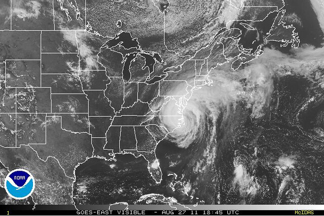
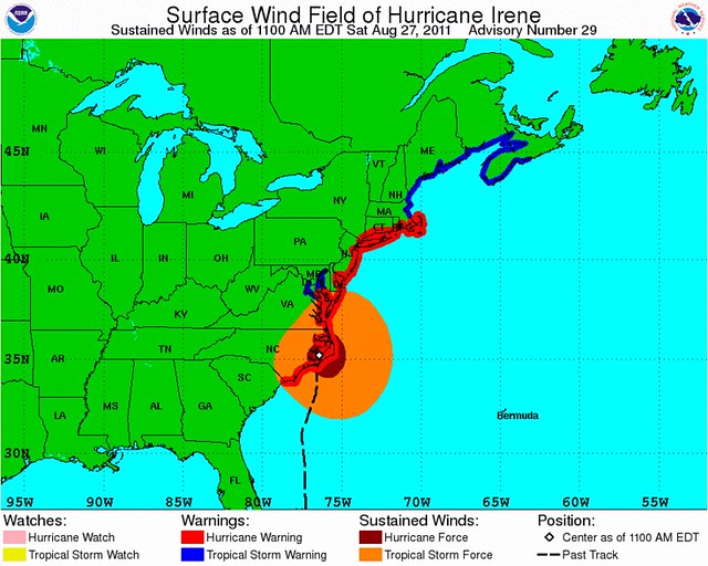
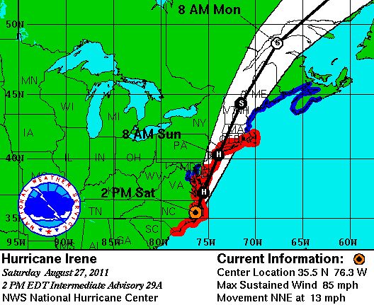
After wobbling a bit to the “left” after landfall at Cape Lookout, North Carolina — seeming to perhaps imply, for a few hours, the possibility of a track further inland than expected — Hurricane Irene has wobbled back to the “right,” and is about to emerge back over open waters:
Mind you, hurricanes always wobble, so this doesn’t mean that it’s suddenly going to go out to sea or anything. Think of it as a correction to the previous wobble, putting the storm back on track. I’d say Irene is still very much on course for the expected grazing/raking of basically the entire mid-Atlantic coast.
Speaking of which, check out this tidal gauge chart from Yorktown, VA, near the mouth of Chesapeake Bay:
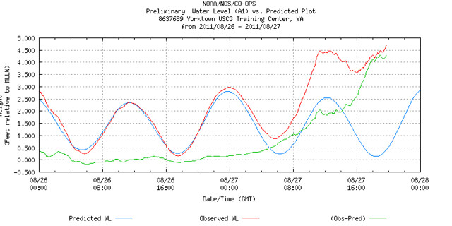
The blue line is the expected, “normal” water level, as the tides come in and out. The red line is the actual water level. The green line is the “residual” water level, showing how much above normal it is. The concerning part is how, since the last high tide around 8am local time (12:00 GMT on the chart), the tide has been unable to go out. This is a consequence of Irene being so large and slow-moving, so its winds pile water onto the same shorelines (and into the same bays) for hours and hours and hours, throughout an entire tidal cycle or even multiple cycles. Anyway, although Yorktown is presently at low tide, the water is just as high as it was at the last high tide — and rising. The next high tide is four hours away, give or take, and so is the center of Irene. With onshore winds pounding the bay as the storm approaches, both the red and green lines are about to start really climbing.
A similar problem is expected to occur at the next tide cycle in the New Jersey and New York area. Hence those evacuations. It’s not about the wind, folks, it’s about the water. More tidal gauges here and here.
Worth watching: The Battery, NY tidal gauge. Next high tide is at 7:30 PM local time, and then critically, the next low tide is at 2:14 AM. Watch how much the tide goes out (or doesn’t) between 7:30pm and 2:14am. Then comes the critical high tide, at 8:07 AM, when the storm’s center is forecast to be very, very nearby. If New York is going to flood, that’s when it will happen. Just 4 or 5 feet above the “normal” high tide (i.e., the blue line) — which is actually already elevated due to the New Moon — might do it.
As long as I’m geeking out with charts and graphs (hey, they don’t call me the “Weather Nerd” for nothing), here’s another fun chart, showing pressure and wind at Cape Lookout as the storm made landfall:
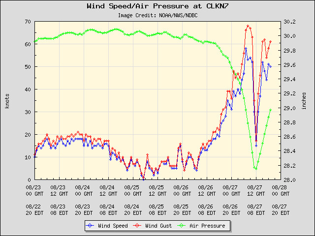
The wind speeds do not actually reach hurricane force (74+ mph), instead topping out around 67 mph. That might lead one to believe that Irene was actually a strong tropical storm at landfall in North Carolina… but that’s hard to believe, with such a low pressure reading (952 mb is usually more associated with a Category 3 hurricane), and in any event, there are wind reports from elsewhere in the Outer Banks that are stronger. For instance:
The Cedar Island Ferry Terminal measured sustained winds of 90 mph, gusting to 110 mph at 7:19am, and a trained spotter on Atlantic Beach measured sustained winds of 85 mph, gusting to 101 mph at 10:35 am. The Hurricane Hunters measured 80 mph winds over water at the time of landfall.
Interestingly, and perhaps somewhat relatedly, the previously linked radar animation seems to show Irene at its strongest several hours after landfall. The after-the-fact meteorological analysis of this storm will be very interesting.
For now, looking forward, nothing has really changed. Irene is still headed toward the northeast megalopolises, still a Category 1 hurricane(-ish), still a moderate wind threat, still a major storm surge and inland flooding threat. On the latter point, here’s a predicted rainfall map:
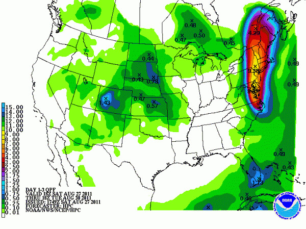
And, per Dr. Jeff Masters, radar verifies huge rain totals falling in the storm’s path. That’s going to be a big, big deal.
Everyone should be pretty well done with preparations by now. Time to hunker down and hope for the best!


Join the conversation as a VIP Member