

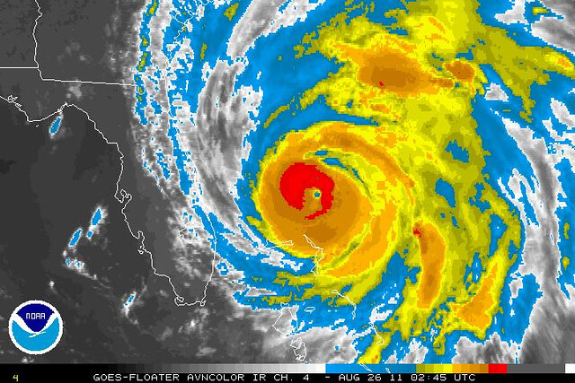
Hurricane Irene is “still” a minimal Category 3 — really, she’s back up to true Cat. 3 status after an unacknowledged weakening to Cat. 2 strength that lasted most of the day — and her barometric pressure is down to 942 MB (or, according to one recon report, 936 MB). Such pressure readings are usually associated with a Category 4 hurricane, i.e. with winds of 131 mph or greater, yet Irene is stuck on 115 mph. This means one of three things. Either:
1. Irene’s winds are about to “catch up” with her pressure. We see this all the time. She’ll ramp up overnight, and we’ll wake up to a terrifying-looking monster storm menacing the coast, with a perfect eye and 135+ mph winds. Or:
2. Irene isn’t getting stronger, in terms of wind speed. Instead, she’s getting bigger. Her wind field is spreading out, and the low pressure is basically supporting that expansion instead of supporting much strengthening. We’ve seen this before, e.g., with enormous Ike, which was a 944 mb Category 2 with 100 mph winds at one point. Or:
3. Some combination of the two.
We’ll find out soon enough which it is. Meanwhile, the storm’s track remains completely uncertain. North Carolina is clearly going to get walloped, but after that, Irene could go just about anywhere along the I-95 corridor. She could track inland, over Virginia and the Chesapeake region, then come at the northeastern corridor cities with its center over land; she could hug the coastline and deliver heavy blows to Delaware Bay and the New Jersey shore; or she could track right over NYC, or Long Island; or she could go further east toward Cape Cod & environs. And she could be a Category 2, a Category 1, or even a tropical storm. We just don’t know yet.
Meanwhile, regardless of Irene’s exact position and strength at landfall, inland flooding is going to be a huge problem. We’re talking about a foot or more of rain on already saturated ground.


Join the conversation as a VIP Member