10:43 AM EDT: A local National Weather Service official confirms what I reported earlier, based on the tidal gauges: Galveston experienced a “less severe storm surge” than anticipated, “only” 9 to 12 feet. And Eric Berger quotes UT engineer Gordon Wells as saying:
Damage from inundation caused by storm surge will be widespread across the region, but should not reach the catastrophic level that would have occurred, if several model predictions materialized. Heavy rains continue across the Houston metropolitan region, and bayou flooding may replace the storm surge threat, but if Ike exits the region on schedule, Southeast Texas will have escaped the worst.
Nevertheless, according to commenter Trent Telenko, local TV reports state that “most of Galveston Island is underwater, in some places 10-15 feet” — though Wells says the surge levels should translate to only “6-7 feet of water in the bayside area of the city, including UTMB and The Strand.” Whatever the exact amount, Houston Chronicle‘s Lindsay Wise confirms significant flooding:
The view from the 12th floor of the San Luis Hotel on the Galveston Seawall at 7:30 a.m. [CDT] was ominous. To the west, literally, was a lake.
Roofs were visible, and the the tops of trees. It looked like the Gulf had come on in.
Behind the hotel, to the northwest, most of the streets and parking lots were clear, and a car even drove by. But only the nearby area behind the wall could be seen; the continued rain and overcast cut visibility to less than a mile.
Seawall Boulevard was covered with broken glass and other debris, but was not under water, although tall waves continued to crash along it.
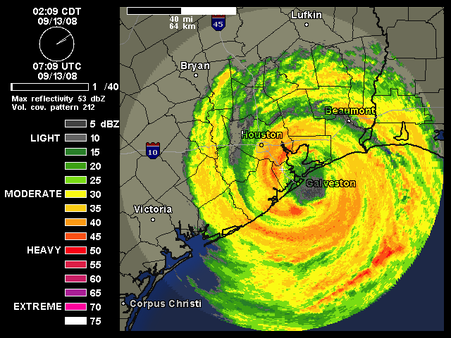
Meanwhile, although the surge was less severe than expected, it sounds like wind damage in Houston may have been worse than expected. The same NWS official mentioned earlier also said that “[a]s the hurricane approached the island, the winds were not as dramatic as earlier predicted… [but as] the eye of the storm moved further inland, the winds became more intense.” This is likely because of the circulation “tightening” due to interaction with land. And, as you can see in this archived radar loop, the western portion of the storm’s intense, tightening eyewall went right over downtown Houston.
Telenko has been watching local TV stations, and posting damage reports in comments. Among them:
There are trees down everywhere. More than 90% of Centerpoint Energy’s 2 million Houston area customers are without power. They are saying it will be weeks before all power is restored. . . . .
Channel 11 Houston just showed the east side of the JP Morgan tower — a 75 story sky scraper — and every window on the east side of the building has been blown out by wind.
Harris County also just briefed that only under ground power lines in Down Town Houston and the Texas Medical center survived the storm. All above ground electrical power lines are heavily damaged and inoperative in the Houston Area. . . .
Channel 11 Houston reports several square blocks of down town Houston are impassable to vehicles due to broken glass and other debris accumulated by winds between sky scrapers.
Alan Sullivan writes, “If Houston sustained this much damage in a cat 2 direct hit, imagine cat 4. It sounds as though local infrastructure needs review and upgrade. Maybe the city without zoning also lacks a building code, or fails to enforce the one it has.”
P.S. About that “bayou flooding” Wells mentioned, Berger has more detail:
White Oak Bayou: At 6 a.m. this morning White Oak Bayou had overtopped its banks. The bayou’s stage at Heights Boulevard was 37.6 feet, well above the flood stage of 32 feet. Forecasters say the bayou is expected to rise to 38 or 39 feet. That’s the level at which major lowland flooding occurs.
Buffalo Bayou: At 6 a.m. the stage was 23.1 feet, below the flood stage of 28 feet. Forecasters said the bayou should rise to near 29.5 feet this morning, a level which should produce moderate lowland flooding.
Greens Bayou: The bayou’s stage near U.S. 59 was at 52.1 feet on Saturday morning, below the flood stage of 55 feet. But the bayou was forecast to rise to near 56.2 feet this afternoon, which should produce some moderate lowland flooding.
UPDATE, 11:11 AM: The National Hurricane Center’s 11:00 AM EDT advisory is out. The discussion says:
ALTHOUGH IKE IS SPINNING DOWN AS A HURRICANE IN TERMS OF MAXIMUM WINDS…UNFORTUNATELY…ATMOSPHERIC CONDITIONS WILL GRADUALLY BECOME MORE FAVORABLE FOR TORNADOES TO DEVELOP ACROSS MUCH OF EASTERN TEXAS…WESTERN LOUISIANA…AND ARKANSAS THROUGH TONIGHT. LOCALLY HEAVY RAINFALL WILL ALSO BE A THREAT…AS WILL CONTINUED HIGHER THAN NORMAL TIDE LEVELS ALONG MUCH OF THE WESTERN LOUISIANA AND UPPER TEXAS COASTAL AREAS THROUGH AT LEAST THIS AFTERNOON.


I would’ve thought that the storm surge was a directly measurable event (by buoys or whatever), as for example is wind speed. Now, I don’t know anything about this stuff (I’m not a meteorologist), but I just would’ve thought that the movement of water was directly measurable, as opposed to just being modeled…
The winds and rising water damages the tide gauges and weather buoys. Even if the gauges are not washed out their transmitters will be down due to wind damage or power outage. Once they can be accessed physically, we may get specific measurements. But remember that shoreline topography and beach bathymetry will affect the local height of tidal surge, so some areas will experience more than the measured surge at the gauge, which is in the port or harbor.
In other words, you guys blew it.
You hyped a minor storm into a major catastrophe and freaked people out. I hope you’re happy.
In Bastrop County, just NE Of Houston we did not even get 1 drop of rain.
Next time guess who we’re going to listen to? Right.
Paul, yes actually, I am happy that Ike turned out not to be a catastrophe. Aren’t you?
Beyond that, your “argument” is deeply unserious. It fails to grapple with any of the difficult issues raised by this sort of situation. As I always say in response to comments like these, you simply cannot judge pre-storm forecasts on the basis of post-storm hindsight. Hindsight is always 20/20. You can only judge pre-storm forecasts on the basis of the best information available at the time the forecasts were made. Forecasts are never perfectly accurate; that is their nature. In this case, the inevitable margin of error in the forecast (re: Ike’s exact track, which wobbled just east of Galveston Island in the final hours before landfall) was compounded by an unexpected error in the computer modeling. But the best information available as of yesterday strongly suggested that Ike could — nay, would — have a catastrophic storm surge. And by nightfall, it appeared very probable that this catastrophic surge would hit Galveston and Galveston Bay extremely hard. As it turns out, the computer models were wrong about the surge’s strength, and also, the track deviated slightly from the forecast, sparing Galveston Island and Galveston Bay the worst of even the reduced surge. Alan Sullivan predicted the models’ error, and all credit to him for that, but it wasn’t unreasonable or ridiculous for others, myself included, to trust the models and the experts. The raw data favored the solution we all predicted. That isn’t “hype.” That was the reality, as of yesterday.
For you to swoop in now, after hindsight has proven yesterday’s fully-supported conventional wisdom wrong, and condemn us for “hyping a minor storm into a major catastrophe,” is just incredibly obnoxious. If you’d said this 24 hours ago (like Alan), then you’d at least have some credibility. As it is, you have none. Moreover, regardless of your timing, the fact remains that the forecasts of catastrophe were honest and, based on contemporaneously available information, 100% reasonable.
As always, I challenge you to quote a specific statement I made that was unreasonable when uttered, based on the information then available, and not merely incorrect in hindsight. I don’t think you’ll find any.
Paul’s a troll. Bastrop County is NW of Houston, just E of Austin, and hasn’t been in a projected storm path for days. Crawl back in your hole, troll.
Heh.
I know I shouldn’t feed the trolls. But this particular criticism constantly gets leveled, sometimes even intelligently and articulately, and it is a real belief that desperately needs to be rebutted.
maybe that snarky #$*(&!@# Alan Sullivan needs to stop using natural disasters to score political points and notice that the damage in downtown Houston and surrounding areas is not mass structural failures (that could be attributed to failure of building codes) but from flying debris and ripped up trees, water damage, downed power lines, etc.
Does anyone know the status of the Goose Creek Rehab residents? They were transported to George R Brown convention center on Thursday afternoon, but were refused admittance due to liability concerns. They were supposed to be transported to Dallas. No updates since KHOU’s report on their plight early Friday morning. Any new information will be greatly appreciated. Many thanks!
More Houston TV channel coverage:
Additional light has shown more of the damage to the JP Morgan-Chase building. It appears that the window blow outs stop at about the 45th floor of the 75 floor building.
My guess is we are looking at an interaction between tall buildings that accelerated hurricane winds enough to suck out the windows and office equipment & furniture behind them.
All Houston area water is under a one minute boil water request (not order) to make sure it is potable.
Houston water supply pressures are low due to a pump in the system losing it’s electric power. This means that while the water may be potable, local officials cannot guarantee it. Hence the request.
Pictures from Galveston show that the huge stone memorial to the victims of the 1900 hurricane has been reduced to scattered rubble.
More pictures from Galveston show at least a half dozen single story homes burned to the ground.
Oh my gosh. It’s a mid CAT 2 storm. Before Katina it’d have rated a couple hours of coverage.
Everyone, including you, built it up to be more than it was. Cat 2-3 you stay inside unless you live directly on the ocean front. This from a guy that’s gone through worse.
At least it takes trashing Gov. Palin off the front page.
From Houston Channel 11:
Federal Superhighway I-10 in Houston, in the TC Jester exit area, is under 4-6 feet of water. This is the part of I-10 that went under water during Tropical Storm Allison.
From Dallas Channel 5:
Texas Department of Transportation (TexDOT) highway clearance equipment is staging from Mesquite, Texas to go down US Highway I-59 and other East Texas roads to clear fallen trees.
They are waiting for hurricane force winds and rain to subside enough for it to be safe to move in.
The first rain bands of Hurricane Ike are now arriving in the DFW metroplex.
From Houston Channel 11:
It appears that the majority of traffic lights in the greater Houston metroplex have been destroyed or heavily damaged. Every intersection shown by Channel 11 so far has been in that condition.
Katy, Texas is reported to be without electric power.
More sections of Galveston have been shown. All have heavy wind damage and flood damage. Part of one Galveston Holiday Inn’s outer brick/stone decorative wall about 50 wide at the base and three stories tall has been ripped away. Galveston streets shown that are not under water are covered with major debris fields.
There has been a heavy rotation of a shot of Houston area Motel 6 that lost it’s roof at about 2:30 am this morning.
“The National Weather Service warns anyone that staying in low-lying coastal areas “may face certain death” if they refuse to evacuate. Ike is expected to hit with a 20- to 25- storm surge and winds of perhaps 115 miles per hour.”
The “may face certain death” warning was very unfortunate. Every time the NWS overplays the severity of a storm it is decreasing its credibility for the next dangerous storm. I am not a meteorologist but it amazes me that we can invest so much money in probing, tracking and analyzing gulf hurricanes for so many years and still be off in our storm surge projections by such a large magnitude. The event was right on top of us, moving rather slowly, with scads of measuring instruments and devices, and we STILL got it wrong. I understand that there is no correlation, but it sure makes you wonder how anyone can have confidence in decade-out global climate projections.
FYI your first link to Eric Berger in this post is broken.
>The “may face certain death” warning was very
>unfortunate.
Given the rescues on the Bolivar pennisula and the night people who stayed in Galveston suffered, you will not hear many South Texas residents complaining.
More from Houston Channel 11:
The National Guard and FEMA convoys left their San Antonio staging areas for Houston.
Down town Beaumont Texas went under 7-9 feet of water. Emergency management officials there are urging people who evacuated there not to come back for several days at least.
Downed trees have taken out electric power and phone service. The sewer system is inoperative and the water system is compromised.
General message from multiple emergency management sources:
Debris is puncturing the tires of civilian vehicles venturing out and they are also pulling downed cables (power and phone) into their suspension when they drive over them.
This stops the vehicle, causes further damage to infrastructure, and results in additional pressure on the emergency management folks to take care of the folks doing this.
Paul, Paul, dey down dehr in GALVesSTON. Dey are inuh bad wayyyyyy. But you right, dey alllllllllllways turn! Dem ole ‘caines …. dey alllllllways turn!
(FYI – I was flipping my “Prudhome” switch on, similarly, during Ivan in 2004. Many I made fun of at that time, ended up being really sorry during Katrina. My meanness here has a good purpose)
BTW – I wrote “Prudhome” (sic) but was really thinking about Justin Wilson. Make that, Justaaaahn WilSONNNN.