

[UPDATE: Welcome, InstaPundit readers! For the very latest information, please visit the Weather Nerd homepage. In particular, you may be interested in my new post about the potential threat to Tampa Bay from a “worst-case scenario” storm.]
* * * * *
An exceptional amount of uncertainty surrounds Tropical Storm Fay as she barrels toward Cuba and threatens an eventual landfall in Florida next week.
Where will the storm go? How strong will she get? These questions are very difficult to answer in Fay’s case — even moreso than usual, as compared to other tropical cyclones — and yet the answers are crucial to residents all up and down the Florida coast, who could be staring down a significant hurricane in just over 48 hours. Or maybe not.
Hurricanes, of course, strengthen over warm water and weaken over land, especially mountainous land. Thus, the spectre of land interaction with Cuba and Florida means that tiny in variations Fay’s track, particularly in the next day or so, could have massive significance down the road. As the National Hurricane Center’s 5:00 PM EDT discussion puts it:
FAY COULD STRENGTHEN RAPIDLY IF IT BECOMES WELL ORGANIZED OVER WATER…SUCH AS WHILE PASSING SOUTH OF CUBA OR OVER THE STRAITS OF FLORIDA. ON THE OTHER HAND…IT MIGHT NOT STRENGTHEN MUCH AT ALL IF LAND INTERACTION PREVENTS ORGANIZATION.
This means the precise track over Cuba, the degree of interference by that island’s mountains, and the amount of time between Fay’s exit from Cuba and its landfall in Florida, are all incredibly significant. Yet all of those things are very difficult to forecast with any precision, in part because, as Dr. Jeff Masters notes, unpredictable “wobbles” and center relocations are more likely than usual:
Fay may clip the rugged southeast tip of the island Sunday morning, then traverse the width of Cuba Sunday night over another region of high mountains. Both of these encounters may force sudden jumps in the center position as the storm reforms closer to its heaviest thunderstorm activity. As a result, the track forecast for Fay has a high level of uncertainty.
And, as noted already, the track-forecast uncertainty leads directly to intensity-forecast uncertainty, which is why the NHC discussion — which calls for a Category 1, 85 mph hurricane at landfall — candidly acknowledges, “THIS IS A LOW CONFIDENCE INTENSITY FORECAST.” At this point, Florida could be hit by a weak tropical storm or by a Category 3 hurricane, and these scenarios are about equally plausible.
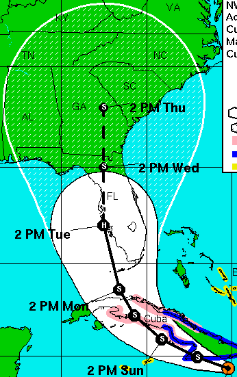
Moreover, just about anywhere in Florida is equally likely to get hit, according to the discussion:
EVERYONE IN THE FLORIDA PENINSULA SHOULD MONITOR THE PROGRESS OF FAY…AS MOST LOCATIONS THERE HAVE ABOUT THE SAME CHANCES OF EXPERIENCING HURRICANE-FORCE WINDS ACCORDING TO THE NHC WIND SPEED PROBABILITY PRODUCT.
For what it’s worth, the official forecast track has Fay coming ashore near Sarasota, just south of the highly storm-surge-vulnerable Tampa Bay. But if there was ever an occasion to truly heed the NHC’s oft-repeated mantra of focusing on the “cone,” not the “black line,” this is it. And the “cone” encompasses the entire state of Florida:
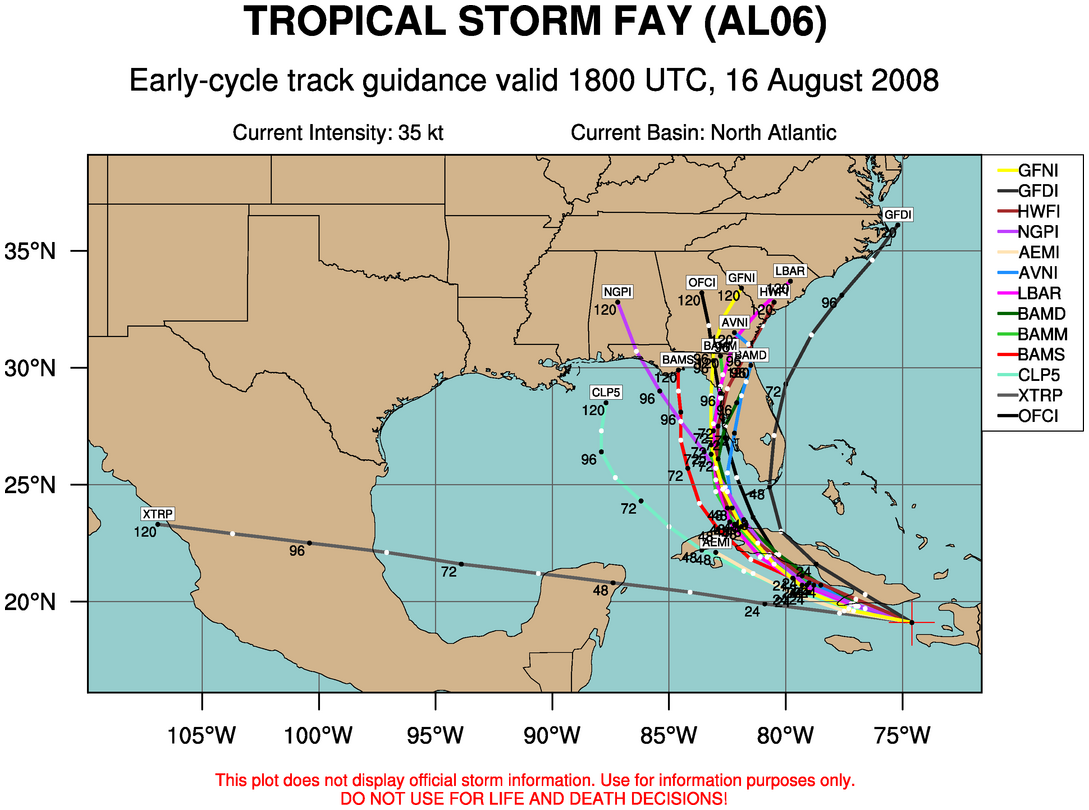
The track uncertainty is expressed well by the “spaghetti” computer-model summary from Colorado State University:
Bottom line, a lot could change in the next 24 hours, depending on where Fay goes and how quickly she strengthens. Stay tuned.
P.S. Eric Berger wrote this morning:
At this time none of the intensity models bring Fay to anything more than a Category 1 hurricane prior to landfall, and the hurricane center’s 90-mph forecast is on the high side of the models.
However there are so many variables at work here it’s difficult to make a guess about Fay’s intensity. The biggest questions are: How long will the storm remain over Cuba? Will Fay stay to the west of the Florida peninsula, rather than hitting the state’s southern edge?
If Fay does stay west of Florida it should move into a low-shear environment during the next couple of days as well as traverse some of the Gulf’s warmest waters.
Because of these factors we cannot discount the possibility of Fay striking the Florida Panhandle as a major hurricane.
Indeed not. Dr. Masters gives a 20% chance of Fay reaching major-hurricane status (Cat. 3 or higher). But as I said, it’s also quite possible Fay could fail to intensify much at all. Everything depends on the track, land interaction, and resulting disruptions to the storm’s organization. And none of that can be predicted with any confidence yet. It’s a perfect storm of nerve-wracking uncertainty.


Join the conversation as a VIP Member