
(In the first half of this essay, Gerrymandering 101, I explained how gerrymandering works and why it’s so ubiquitous. Here in the exciting conclusion I name and shame the ten most gerrymandered districts of the current 111th Congress — plus 20 bizarre bonus districts not mentioned in the title.)
10. North Carolina-12

This is what most people imagine when they think of a gerrymandered district — what I call “Gerrymander Classic.” NC-12 looks very much like the gerrymandered districts of the 19th century, but taken to extremes. As bad as it is, NC-12 at least looks like a congressional district, with meandering lines, consistent width, and hand-drawn appearance. As we’ll soon see, modern gerrymandering is often another animal altogether, with jarring shapes and artificial boundaries that are not just offensive to the eye but somehow feel like an insult to rationality.
9. Florida-20

This is what gerrymandering looks like in the modern era: ugly. Gone are any attempts at aesthetics. In the old days, redistricters at least tried to disguise their gerrymandering by drawing district lines that looked almost kinda sorta reasonable. No more. Nowadays many districts, with FL-20 being a good example, seem to be the result of computer algorithms with no regard whatsoever for human or natural boundaries. Needless to say, all sense of “community” within a congressional is out the window altogether when it is shaped like this, with jagged tendrils reaching out every which way to gobble up the desired demographic.
8. Pennsylvania-12

PA-12 is a rare example of “packing” (jamming as many opposition voters as possible into one district) that backfired. This district was created to be a Democratic stronghold formerly held by Congressman Jack Murtha, who was assumed to have a lock on the district. At the last redistricting in 2000, the Republicans in charge gave up on the area, which is solidly unionized, and decided to “pack” Murtha’s new district with as many Democrats as possible, to allow the remaining districts in the region a chance to have slim Republican majorities. But in the intervening ten years everything has changed: the area grew more and more conservative, and the locally popular Murtha died, opening up the seat to possible challengers. In the 2010 election, PA-12 barely remained Democratic with Mark Critz winning by a hairsbreadth 50.8%-49.2% margin — while most of the surrounding districts overwhelmingly went Republican. Thus, if the foolish 2000 Republican redistricters had not consciously set out to create a “packed” Democratic district, and had instead just drawn the boundaries at random, they could have easily won all the races in the area, instead of losing this one (and the adjacent PA-4) by the slimmest of margins. Note to gerrymanderers: THINGS CHANGE. What may appear to be a wise gerrymander maneuver today may blow up in your face sometime in the future.
7. North Carolina-6

I have included NC-6 as a perfect example of “inverse gerrymandering,” a district that is partly hollowed out internally by a different gerrymandered district — in this case, the northern end of NC-12, our first example above. NC-6 is a stark reminder that no gerrymander is freestanding: all congressional districts are interlocked like jigsaw puzzle pieces, and every time you enclose any area by some outrageous boundary line, you are disincluding that same area from some surrounding district. So for every gerrymander you create, you are likely to also have a less-noticeable but just as offensive inverse gerrymander next door.
6. Florida-3

Florida has more than its fair share of gerrymandering nightmares. But while many of the state’s districts were admittedly drawn to favor Republican candidates, FL-3 is instead a federally mandated “minority-majority” district gerrymandered to give black voters a voice:
[FL-3] was drawn in 1992 to be North Florida’s black-majority seat and Democrats were shifted from the surrounding districts to make the surrounding districts more Republican. It currently stretches from Jacksonville’s downtown in the north to Orlando’s in the south, and stretches east and west to include other largely minority and Democratic areas such as Gainesville, Sanford and Eatonville. As a result of this gerrymandering, the district is strongly Democratic with a Cook Partisan Voting Index of D +18 and gave Obama 73% of its vote in the 2008 election. It is 50.9% black and 35.4% white. … The 3rd District is at the center of the debate over the potential impact of the FairDistricts initiative. Due to its shape, the 3rd is one of several districts that violate restrictions in the initiative which require compact districts that conform to geographical and political boundaries. On the other hand, the 3rd District is protected by the Voting Rights Act and a non-compact shape may be necessary to ensure it remains an effective African-American seat.
The “FairDistricts Initiative,” ballot proposals designed to finally make Florida’s redistricting theoretically nonpartisan, was finally approved by voters this year on November 2 — but was immediately challenged in court not by the Republicans as you might imagine but by none other than Corrine Brown, the representative of FL-3! Why? Because the new law stipulates that districts be geographically compact, which would eliminate her voting bloc and most likely her seat in Congress, when FL-3 is totally reconfigured next year. Which is ironic, because Republicans also view the new law with disdain, seeing it as a plot to swing the redistricting advantage back to the Democrats. Sigh. Can’t we all just get along? (Answer: NO!)
5. Illinois-17

Political scientists love to cite IL-17 as the prototypical gerrymandered district, and you are likely to see IL-17 used as the illustration in many academic treatises about redistricting. And we can see why here. Its shape has often been described as “a rabbit on a skateboard,” though to me it looks more like an embryonic ichneumon wasp with a pancreatic cyst. We saw above how PA-12 was a gerrymandering blunder by the Republicans; IL-17 is the opposite, a gerrymandered district created by Democrats to ensure themselves a seat in western Illinois — but which this year was snatched from their grasp by Tea Party candidate and now congressman-elect Bobby Schilling. Ooops! The Democrats went out on a limb when drawing IL-17 — several limbs, by the looks of it — but the wave election of 2010 changed the electoral landscape. Let me repeat my warning to over-confident redistricters next year: THINGS CHANGE. Gerrymander at your own risk.
4. Florida-22

Florida-22 isn’t a congressional district: it’s series of random lines generated by a malfunctioning dot-matrix printer. What else could explain the sheer purposelessness of the innumerable jagged ins and outs of a district so thin that in a few places you could run across it in under a minute? All of this to achieve — what? A district that is almost perfectly balanced between Democrats and Republicans. Couldn’t the same result have been effected a little more simply, perhaps by circling some random part of a Florida map with a felt pen? But all is forgiven, Florida-22, because on November 2 you elected as your representative Allen West MFC (My Favorite Congressman), quite obviously the next President of the United States.
3. Arizona-2

Arizona’s second district is the one most likely to make people burst out laughing. I mean, c’mon. And the explanation for this atrocity only makes it seem worse:
The odd shape of the district is indicative of the use of gerrymandering in its construction. The unusual division was not, however, drawn to favor politicians. Owing to historic tensions between the Hopi and the Navajo Native American tribes and since tribal boundary disputes are a federal matter, it was thought inappropriate that both tribes should be represented in the U.S. House of Representatives by the same member. Since the Hopi reservation is completely surrounded by the Navajo reservation, and in order to comply with current Arizona redistricting laws, some means of connection was required that avoided including large portions of Navajo land, hence the narrow riverine connection.
So, the district was drawn this way so that Hopis and Navajos don’t give each other “electoral cooties” by having to vote for the same congressman? What — is America now a 3rd-grade playground? Imagine how Republicans in Nancy Pelosi’s district feel, or Democrats in rural Texas. All across America people have to line up at polling places alongside people whom they despise. Get over it.
2. Maryland-3

Maryland-3 is the poster child for the lunacy that is gerrymandering. And the funniest part? The Democratic politicians who created it deny that it’s gerrymandered at all:
The new district was concocted after the 2000 Census when Maryland, like all states, drew up new congressional and state legislative district boundaries to reflect changes in the population.
Former Secretary of State John T. Willis, who was in charge of the redistricting as chairman of the Governor’s Redistricting Advisory Committee, said the committee did not mean for the 3rd District to look like it does. That’s just how the numbers worked out, he said.
“It’s a very complex situation, and population is the No. 1 driving characteristic,” Willis said.
…
The final plan, Willis noted proudly, created eight congressional districts that had almost exactly the same number of people in them.
“All of our congressional districts don’t deviate by more than one person,” he said.
But Rascovar said that no matter how the committee “painted it”, the new boundaries were drawn to favor Democratic candidates in the 2nd District.
“They needed ‘x’ number of votes . . . what you end up doing is juggling these neighborhood votes, and it becomes absurd,” Rascovar said.
“The most absurd is that the politicians drawing up these districts are no longer concerned with the neighborhoods,” he said. “All they care is, ‘How many loyal Democrats can I get in this district?’ ”
Willis disagreed. Although the interests of incumbent representatives were taken into consideration, he said, no single district was favored.
We didn’t draw the district that way on purpose. It was an accident! Honest!
1. Illinois-4

Here it is: The most ridiculous congressional district in the entire country. No, you’re not looking at two districts; IL-4 has two absurdly gerrymandered halves held together by a thin strip of land at its western edge that is nothing more than the median strip along Interstate Highway 294. The end result is a gerrymandered gerrymander, a complete mockery of what congressional representation is even supposed to be. As with AZ-2, the intention behind IL-4 was to create an ethnic enclave, in this case an Hispanic-majority district within an otherwise overwhelmingly non-Hispanic Chicago. Problem is, Chicago has two completely distinct and geographically separate Hispanic neighborhoods — one Puerto Rican, the other Mexican — but neither is large enough to constitute a district majority on its own. Solution? Lump all Hispanics together into a supposedly coherent cultural grouping, and then carefully draw a line surrounding every single Hispanic household in Chicago, linking the two distant neighborhoods by means of an uninhabited highway margin. Voila! One Hispanic congressperson, by design. And as a side-effect, the most preposterous congressional district in the United States.
**************
But wait — our gerrymander tour isn’t over. If you think those ten were bad, you ain’t seen nothin’ yet. While they may have indeed been the ten most gerrymandered districts in the nation, at least they shared something admirable in common: They were legal. The same cannot be said about our next ten districts, which may not be as crazily shaped as the ones above, but which are in one crucial aspect far worse: they’re noncontiguous.
The whole reason gerrymandering even exists as a practice in the first place is to overcome the requirement that each congressional district be contiguous — in other words, a unified single enclosed area, however strangely shaped it may be. This self-evident need to create contiguous districts is the whole reason why gerrymandered district boundaries wander all over the landscape, so as to enclose certain sought-after voters while still keeping them geographically connected to the rest of the district. Without the requirement to have each district be contiguous, politicians could easily have created a new level of fantasmagorial gerrymandering in which demographic groupings are enclosed without any regard to where they might be located on a map, forging “districts” out of disconnected topological islands.
Thank heavens that can never happen, right? Right?
Wrong.
The politicians in charge of redistricting are so brazen in some states that they seem to have gotten drunk on gerrymander wine, tossing caution to the wind and cavalierly creating noncontiguous congressional districts with portions completely cut off from the rest of the voters. How in the world they got away with this, I have no idea — apparently, if you have the hubris to create gerrymandered districts in the first place, it’s not so big a step to cross the invisible boundary between unethical and illegal.
That said, I am unaware of any federal law stipulating that districts be contiguous; it seems to be legislated on a state-by-state basis. And it could very well be that certain states intentionally fail to pass or enforce such a law, if it serves a political purpose to violate it. After all, who’s going to prosecute the redistricters? Themselves?
If this trend continues, perhaps the time has come to enact nationwide guidelines expressly prohibiting noncontiguous congressional districts. Until that time, we’ll have…
The Top Ten Most Blatantly Illegal Noncontiguous Congressional Districts…
10. New York-12

OK, somebody’s got to go to jail for this crime against common sense. NY-12 isn’t just noncontiguous — it’s composed of four completely separate geographical enclaves, scattered across Brooklyn, Manhattan and Queens. Talk about brazen. This is the step beyond mere partisan bias — I hereby dub it “cherrymandering,” a combination of cherrypicking and gerrymandering.
9. New York-8

New York apparently has no ethical guidelines or laws against cheating, because here they are at it again: NY-8, like its neighbor NY-12, is utterly, laughably noncontiguous. It may have only two separate components (as opposed to four), but they’re not even close to each other. How in the world did the redistricters get away with this? It’s not like the district is off in the backwoods somehwere, with no one around to notice: NY-8 covers much of central Manhattan, with many world-famous landmarks. Hellooooo???
8. North Carolina-3

NC-3 may be more noncontiguous than any other district in the nation. As far as I can tell, it’s composed of at least five different coastal enclaves, none of which actually touch each other. Their excuse? They’re all “connected” by the islands of the Outer Banks offshore, even though the connection is only theoretical, not physical.
7. Maryland-2

MD-2 was in the running for the most gerymandered district in the U.S., but its noncontiguity moved it into a category all its own. For not only is the northern part of the district hilariously gerrymandered in the extreme, but the southern part has not just one but two completely disconnected components sitting off all by themselves. Seriously: How did they get away with this?
6. Florida-11

Another strong contender for “Most Illegal Congressional District in the Country,” FL-6 has, under close inspection, at least six separate noncontiguous outposts (although three of them are quite small). Apparently, the Florida redistricters think that if a road connects two areas widely separated by water, then they count as being adjacent.
5. Florida-10

FL-10 is FL-11’s northern twin, once more with a patently noncontiguous outpost around Palm Harbor.
4. Florida-18

And finally we have FL-18, the last of the Florida Quartet of Noncontiguous Districts. The map above doesn’t show it, but other maps, such as this one produced for the election by the New York Times, indicate that FL-18 includes isolated shoreline enclaves scattered across the southern tip of the Florida peninsula:

I’ve found several other maps confirming the inclusion of these noncontiguous enclaves, so FL-18 earns a spot on this list of shame.
3. Texas-14

TX-14, like NC-3 above, is a series of noncontiguous mainland outposts “connected” by a series of freestanding offshore islands. But could you walk from one end of the district to the other, without crossing other districts? No.
2. Maryland-1

Maryland also apparently subscribes to the “a bridge counts as land” theory of congressional redistricting: two areas on opposite sides of Chesapeake Bay are fused into a single district, connected only by a highway bridge.
1. New Jersey-13

And lastly, NJ-13. New Jersey has only one entry on this page, but it’s a doozy: the state’s 13th district consists of two almost equal halves, separated by several miles of open land (part of a different district). It’s like they didn’t even try to make it contiguous. Couldn’t they have at least made a pro forma gesture, like running a thin strip along the beach or underwater or something?
Dishonorable Mention: Ten More Notable Gerrymandered Districts…
10. Tennessee-7

I hereby nominate the nickname “Isadora Duncan’s scarf fluttering dangerously close to the back wheel” to decribe TN-7’s shape.
9. Maryland-4

Yes, a gerrymandered district even surrounds Washington, DC itself. It’d be ironic if it wasn’t so predictable.
8. Massachusetts-4

Barney Frank’s MA-4 wins the award for District That Most Resembles the Original Gerry-Mander.
7. Florida-16

Spanish gold from shipwrecked 18th-century galleons isn’t the only treasure to be found in Florida; gerrymander-hunters know that Florida is the Mother Lode for ridiculous congressional districts, with glittering examples to be found all across the state. A prime example is Florida-16, perhaps one of the ugliest districts in the nation. It starts on Florida’s west coast with a series of soulless rectangles, traverses the entire peninsula and seems to peter out at the Atlantic shoreline…until you notice that the district seems to be leaking out of a tiny fissure on the beach and then drips down the eastern coast, before terminating inland once again. No human could have possibly conceived of such a monstrosity; only a software algorithm could be so unconcerned with proportion or harmony.
6. Florida-23

Florida-23 doesn’t look so bad at first glance, until you notice something screwy with its eastern edge. A seemingly sensible district degenerates into a series of apparently purposeless microscopic zigzags, so miniscule that this map doesn’t really capture their intricacy. Needless to say, this is the obvious handiwork of the computer that Florida politicians used to maximize their redistricting manipulation.
5. Florida-19

Florida-19 isn’t so much a congressional district as it is a glob of “gerrymandering leftovers.” Trapped between the computer-generated hyper-precise boundaries of Florida’s 22nd and 23rd districts, each of which was designed to encompass very specific electorates, FL-19 is little more than the area that didn’t match the required demographic profile of the other two districts. The orphaned territory was geographically cut off from the rest of the state, and so was necessarily designated as a district of its own, one with no cultural, geological or political coherence.
4. California-38

Despite being the most populous state, and thus having the most districts available for abuse, California is surprisingly only mildly afflicted with the gerrymandering bug. CA-38 is one of the very few districts in the state which can compete with the severe gerrymandering found elsewhere in the country. Since California’s political process is corrupt in the extreme, the only explanation for the lack of gerrymandering is that the state’s residents already self-segregate into crisply defined political zones. California may be ethnically integrated, but the state’s political camps don’t mix; Most Democrats wouldn’t be caught dead living withing five miles of a Republican, and vice versa. Politically mixed neighborhoods or areas are a rarity. Thus, there’s little need for gerrymandering, and on those few occasions where it would come in handy, it’s fairly easy to draw district boundaries to include the sought-after voters without creating a map-monster.
3. Illinois-19

IL-19 goes by the name “Water-Skier Checking His iPad for Emails.”
2. North Carolina-1

The entire coastline of North Carolina is egregiously gerrymandered, NC-1 being no exception.
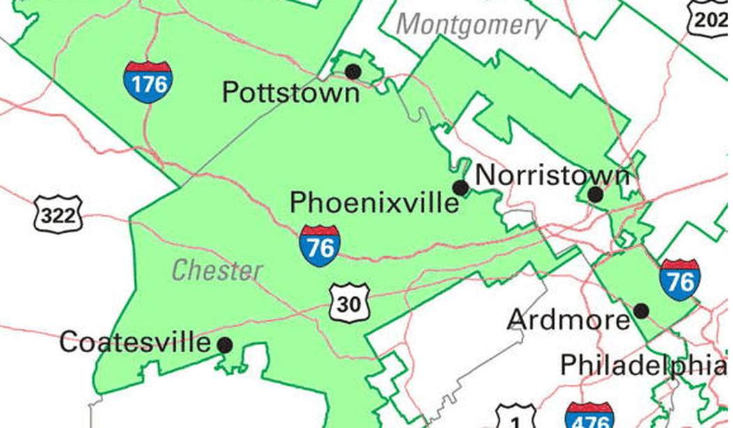
1. Pennsylvania-6

And bringing up the rear we have PA-6, which would have won the award for butt-ugliest district if it didn’t have so much brutal competition.
*********
Curious to learn more about gerrymandering? Check out the first half of this essay, Gerrymandering 101.
More gerrymander-themed links:
– If you want to find out who won each of these gerrymandered districts in the 2010 elections, the New York Times election results page has a complete rundown of the winners and losers.
– All of the images in this report were derived from the official maps found at the National Atlas.
– A 2002 article in The Economist called “How to rig an election” is out-of-date but does give a good overview of gerrymandering, and explains how computer-assisted redistricting has made things much worse in the modern era.
– The Gerrymander Mojo Index gives a visual overview of district boundary complexity across the whole country, district-by-district.


Join the conversation as a VIP Member