

Tropical Storm Sandy was upgraded to a hurricane at 11:00 AM Eastern Time, and its central pressure has dropped another 5 millibars in the 90 minutes since the last reading, indicating a rapidly strengthening storm. Thankfully, Sandy will soon run out of time to strengthen further. Unfortunately, the reason for this is that Hurricane Sandy is nearing landfall in Jamaica, where the impact will be worsened by the storm’s ongoing intensification — all else being equal, strengthening hurricanes are more damaging than weakening or steady-state hurricanes of the same stated intensity at landfall.
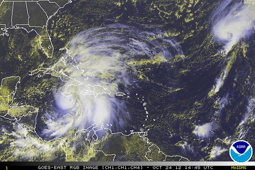
After Jamaica, Sandy will briefly re-emerge over water, but will then hit eastern Cuba. By the time it emerges from its passage over Cuba, the upper-level wind shear will have increased, likely preventing much further strengthening — at least as a pure warm-core tropical system. (More in a moment on what I mean by that.) All things considered, it is unlikely Sandy will, in its purely tropical phase, ever be worse than a Category 1 hurricane.
However, after Sandy crosses Jamaica and Cuba, things get really interesting — and dangerous — because the atmospheric setup is uniquely conducive for Sandy to become a bizarre and, possibly, extremely destructive hybrid storm, injecting its tropical moisture, warm core, and low barometric pressure into a dynamic atmospheric situation involving a diving upper-level trough, driven by the jet stream, and the resulting clash between warm and very cold air. We could end up with a “subtropical hurricane” — a category that isn’t even supposed to be able to exist — bashing the U.S. East Coast with fierce wind, rain and surge, while its back side produces extremely heavy snow over the northern Appalachians. It would be like a nor’easter on steroids.
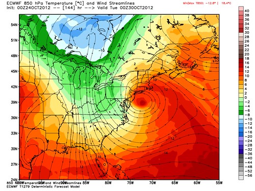
This computer model forecast map tweeted by Dr. Ryan Maue, shows the temperature contrast well. This is not something you would see with a typical hurricane.
Dr. Jeff Masters believes Sandy has the potential to be a billion-dollar disaster for the Northeast and Mid-Atlantic:
On Friday, a very complicated meteorological situation unfolds, as Sandy interacts with a trough of low pressure approaching the U.S. East Coast and trough of low pressure over the Central Atlantic. The Central Atlantic trough may be strong enough to pull Sandy northeastwards, out to sea, as predicted by the official NHC forecast, and the 06Z GFS, 00Z UKMET, 00Z Canadian, and 06Z HWRF models (00Z is 8 pm EDT, and 06Z is 2 am EDT.) However, an alternative solution, shown by the 00Z ECMWF, 06Z GFDL, and 06Z NOGAPS models, is for Sandy to get caught up by the trough approaching the Eastern U.S., which will inject a large amount of energy into Sandy, converting it to a powerful subtropical storm that hits the mid-Atlantic or New England early next week with a central pressure below 960 mb and sustained winds of 60 – 70 mph. Such a storm would likely cause massive power outages and over a billion dollars in damage, as trees still in leaf take out power grids, and heavy rains and coastal storm surges create damaging flooding. The full moon is on Monday, which means astronomical tides will be at their peak for the month, increasing potential storm surge flooding. A similar meteorological situation occurred in October 1991, when Hurricane Grace became absorbed by a Nor’easter, becoming the so-called “Perfect Storm” that killed 13 people and did over $200 million in damage in the Northeast U.S.
Depending on Sandy’s eventual track, strength and structure — all of which are very much in flux right now — there is some potential for this storm to bring a real nightmare scenario to the highly vulnerable New York City region, with storm surge and extremely high surf getting funneled into the harbor (at astronomical high tide, no less!). This is just a hypothetical at this point, and it probably won’t happen precisely that way, but it’s concerning to me that the scenario is on the table, and is one of many reasons that Sandy bears watching.
Not to get all Nate Silver on you, but it’s important to recognize and articulate the vast uncertainties here. There are a variety of scenarios in play, ranging from good (out to sea!) to bad to very bad to potentially catastrophic, but there are also an enormous number of variables, particularly in a dynamic and highly unusual atmospheric environment like this. Geoff Fox, an excellent TV meteorologist at Connecticut’s one major news station based on the coastline, WTNH Fox affiliate, WTIC, gets at this in his latest blog post:
Here’s my problem with Sandy. I can look at all the computer runs and sense something’s wrong. Too many things are happening I’ve never seen before. You’d think in nearly 30 years here I’d seen it all.
I spoke to Bob Hart on my way home. He’s a professor at FSU. No one knows more about tropical weather. … Bob said there were some storms in the 1800s that produced what is Sandy’s worst case scenario.
There’s a reason stuff like this happens infrequently. A huge number of conditions must come into alignment. If one or two aren’t as forecast it all goes to hell! With Sandy this far away in time and distance there’s no parameter that’s not suspect. …
We talked about the weaknesses of models. … Tropical systems are really small compared to the weather we most often see. The computer models are often too coarse to understand the complexity of these tightly wound storms that mathematically can fall between the cracks.
Dr. Masters thinks, or at least hopes, the computer models will start to get a better handle on Sandy soon:
The models vary significantly in their predictions of when Sandy might arrive along the U.S. coast. The 06Z NOGAPS model predicts Sandy’s heavy rains will arrive on North Carolina’s Outer Banks on Saturday, then spread into the mid-Atlantic and New England on Sunday. The 00Z ECMWF model predicts that Sandy’s rains won’t affect North Carolina until Sunday, with the storm making landfall in New Jersey on Monday night. The GFDL model is in-between these extremes, taking Sandy ashore in Delaware on Monday morning. The trough of low pressure that Sandy will be interacting with just moved ashore over the Western U.S. this morning, and got sampled by the 12Z (8 am EDT) set of land-based balloon-borne radiosondes for the first time. One of the reasons the models have been in such poor agreement on the long-term fate of Sandy is that the strength of this trough has not been very well known, since it has been over the ocean where we have limited data. Now that the trough is over land, it will be better sampled, and the next set of 12Z model runs, due out this afternoon between 2 pm – 4pm EDT, will hopefully begin to converge on a common solution.
Stay tuned. I’ll be tweeting about Sandy as well at @brendanloy. (Fair warning: most PJM readers may not care for my political tweets. If so, just ignore those, and look for the hurricane-related tweets. :))
AFTER THE JUMP: Sandy’s potential impact on the presidential election.
P.S. Speaking of politics, it’s worth noting that two major swing states — Virginia and New Hampshire — plus North Carolina and Pennsylvania, if you consider those genuine swing states (I never have; I’ve always said Obama would only win NC if he’s comfortably ahead nationally, and the same in reverse for Romney in PA), and to a lesser extent Florida, could be impacted by this storm in the week before the election. Heck, the eastern part of Ohio, the swing state to end all swing states, may get some snow from it. Campaign travel planners, be alert.
P.P.S. If Sandy does strike the northeast a week before the election, and does cause massive, widespread and long-lasting power outages, as well as enormous damage to trees and such — not to mention crippling snow over the Appalachians (and maybe parts of Ohio???) — it might affect more than campaign travel. We could well see depressed voter turnout throughout the affected region, if the infrastructural damage is still being significantly felt a week later, which seems possible. That might not affect the outcome of the presidential race (unless Ohio really is hard-hit), but, as my father points out via e-mail, it could harm President Obama’s popular vote totals, if folks in Democratic strongholds — particularly New York — don’t vote because the storm’s aftermath makes it too inconvenient (and besides, they know they aren’t in a swing state, so why go to all the extra trouble?). There’s been a lot of talk about Obama winning the electoral vote but losing the popular vote, like Bush in 2000; in a worst-case scenario, Sandy’s effects could made that more likely. Sandy could also impact some key congressional races, notably the U.S. Senate battles in Connecticut and Massachusetts.
This is all highly speculative, of course, but an interesting possibility to consider, and probably more worthy of your attention today than anything Donald Trump or Gloria Allred might have to say.
IMPORTANT NOTE: Most states in the region potentially affected by Sandy – including New Hampshire, Virginia and Pennsylvania, and the Senate battlegrounds of Connecticut and Massachusetts – do not permit routine early voting. You can vote absentee, but only with a specific allowable excuse. So almost everyone must vote on Election Day.
Ohio, of course, does have early voting. The campaigns may want to put an even greater emphasis on encouraging it now, just in case Sandy’s western reaches have a significant impact in the Buckeye State. (I frankly have no real idea how realistic that possibility is, though Joe Bastardi does have far eastern Ohio on the boundary of his “damaging snow threat” zone.)
UPDATE: Harold Ambler, a fellow weatherblogger and a climate-change skeptic (lest anyone think that this storm is some sort of AGW hype invention), sums things up nicely. He actually criticizes the National Weather Service, gently, for not hyping the storm enough, noting that the NWS is still describing this as a “low” probability event:
Top-of-the-line computer models have been forecasting a devastating blow delivered by Hurricane Sandy to the Northeast early next week for several days now. In the computer model scenarios, Sandy could come ashore anywhere from Maryland to Cape Cod and would do damage to a wide swath of coastline and many inland locations as well. …
That the NWS wants to avoid worrying the public over a “fish storm” made perfect sense for the initial two or three days that Sandy began to be seen by the computer models. However, as of this writing, the great majority of members of NOAA’s Global Forecast System climate model are indicating a curve toward New York City and the densely populated I-95 corridor.
With Arctic air rushing south on the western edge of Sandy as it makes landfall, the potential exists for an unusual (though not unprecedented) one-two punch, with the dire effects of a hurricane on the coast (and well inland) and a crippling snowstorm 250 miles to the west.
A full moon early next week, and its attendant astronomic high tides, stands to increase the effects of beach erosion and storm surge.
In this observer’s opinion, preliminary preparations for the tens of millions living in the region that would be affected by Sandy should be begun before the weekend, with unusually long power outages among the risks posed by the storm.
There’s a reason that the NWS avoids making forecasts too soon: It can’t afford to cry wolf. But it’s time to let the public know that something is in the offing here.
The situation is that serious.
This observer would tend to agree, though I’d say we probably have one more day to watch and wait. If the model forecasts still look dire tomorrow, it’s time to begin really preparing in earnest for the worst.
On Twitter, Ambler adds:
Hurricane Sandy has the potential to make people forget Irene and Halloween snow from 2011. May it instead turn out to sea…
Possible effects of Hurricane Sandy:
1. SEVERE coastal erosion
2. damaging storm surge
3. flooding rains
4. crippling snows on western edge
5. people without electricity for a long time
6. voting turnout affected the next week
7. President Obama having to tend to a national emergency in the run-up to the election
I might add, “8. Mitt Romney needing to blunt harsh criticisms of President Obama in the final days of the campaign because of the perception that it’s unseemly to attack the president when he’s tending to a national emergency.” Unless of course the Obama Administration’s response is perceived as inadequate or incompetent, in which case all bets are off. Likewise, in this scenario, Obama would need to cool it with the attacks on Romney during the final week of the campaign, and with campaigning generally, in order to appear focused on addressing the national emergency. Joe Biden and perhaps Bill Clinton would probably become Obama’s major campaign-trail surrogates in such a scenario, and their message would need to be less hard-edged because of the sensitivities of the moment.
I suspect, if Sandy continues to look like a big potential problem — a “big f***ing deal,” as someone once said — we’ll soon start to see conspiracy theories suggesting that Obama will try to delay the election because of the storm. That won’t happen. But, in a worst-case scenario, Sandy and its aftermath could definitely become a big part of the story of the election.
ANOTHER UPDATE: More from Geoff Fox:
I just took a look at the European (ECMWF) and GFS models. They’re our best predictors for medium range weather. Both are now predicting an East Coast strike for Hurricane Sandy. Obviously that is not good news.
The GFS brings landfall to Maine while the Euro hits New Jersey just south of New York City.
Let’s get real for a moment. Both of these models have varied greatly over the last few days. They have changed trajectories by hundreds of miles. There’s a big difference between striking Cape Cod and Asbury Park as the European model has suggested over the last day.
I am more concerned than I was yesterday. Both of today’s scenarios would affect Connecticut and, of course, we’re the compromise position between the two.
It’s still too early to go nuts, but it is the time to start thinking about what you wish you’d had on hand during Irene.
Do you use rechargeable batteries? Are they charged?
Do you have food in your freezer you’d like to start using now?
Are your prescriptions up-to-date?
New England is nothing more than a potential target for Hurricane Sandy. It is still too early to think its post-weekend location can be accurately forecast.
As we get closer we’ll know more.
Yup.


Join the conversation as a VIP Member