
Tropical Storm Karen continues to move north-northwest toward a weekend date with the northern Gulf coast of the United States, somewhere between Louisiana and Florida (exact location TBD). But, as expected, Karen is struggling with upper-level wind shear, and it looks increasingly unlikely that she will ever become a hurricane.
Via @JeffBaskinFOX16, a satellite/radar map of disorganized #Karen also showing NHC track points thru Saturday PM: pic.twitter.com/EakfqLchOo
— Brendan Loy (@brendanloy) October 4, 2013
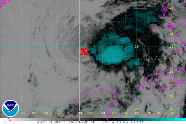
Here’s the current water-vapor satellite loop:

A couple of things to note about the above map. First, the brown stuff over the western Gulf, Texas, Louisiana, and Mississippi is dry air. That will likely become an issue for Karen as it gets closer to shore, and its circulation potentially sucks some of that in. Second, the wind shear — i.e., those strong winds from southwest to northeast across the system, pushing the high clouds and thunderstorms away from the center of circulation, which is exposed off to the southwest of the main area of overcast and rain. That’s not a sign of a healthy, strengthening tropical cyclone — and it’s not likely to improve. In fact, conditions are only expected to get less favorable, which is why this 65 mph tropical storm seems unlikely to gain the last 9 mph needed to become a hurricane.
Here’s what the official 11pm EDT discussion had to say about Karen’s intensity prospects:
KAREN CONTINUES TO BE A SHEARED CYCLONE WITH A VIGOROUS CIRCULATION…AND WITH MOST OF THE THUNDERSTORM ACTIVITY TO THE NORTH AND EAST OF THE CENTER. … THE SHEAR AFFECTING KAREN IS FORECAST TO INCREASE AND THIS WOULD SUGGEST WEAKENING. IT IS BECOMING LESS REALISTIC THAT KAREN WILL BECOME A HURRICANE IN A DAY OR TWO…BUT GIVING CREDIT TO SOME DYNAMICAL MODELS…LIKE THE HWRF…WHICH DO [FORECAST INTENSIFICATION TO HURRICANE STRENGTH]…THE NHC FORECAST CALLS FOR A SLIGHT STRENGTHENING. IT IS ANTICIPATED THAT KAREN WILL BE ON A WEAKENING TREND BEYOND 48 HOURS…AND BECOME EXTRATROPICAL BY DAY 4.
Translation: “The human forecasters ain’t buying it, but some of the computers still think Karen will become a hurricane, so we’ll split the difference and forecast mild strengthening to 70 mph, followed by weakening. But we don’t really believe even that.”
As for Karen’s track, there isn’t much more clarity tonight than there was 11 hours ago. The most reliable American global model (GFS) continues to be a far-right outlier [INSERT GOVERNMENT SHUTDOWN JOKE HERE], forecasting a landfall near the Big Bend of Florida, followed by re-emergence off the Carolinas!
GFS – Landfall on FL Big Bend Monday morning strong TS/CAT 1…more time over water in this run & slower pic.twitter.com/2LXAPzWO6l
— HurricaneTracker App (@hurrtrackerapp) October 4, 2013
GFS 00z has #Karen on a NE track off Carolina coast early next week. Very far right outlier model solution. pic.twitter.com/4CHSP2djNj
— Ryan Maue (@RyanMaue) October 4, 2013
But that seems pretty unlikely to most observers. The model consensus calls instead for a landfall point somewhere between southeastern Louisiana and the western Florida panhandle, in the vicinity of Destin, where my family vacationed earlier this year. (Very glad we picked May over October, which we also considered!) That’s still a wide range, though. Hopefully the models will get a better handle on the track tomorrow.
In the mean time, folks in Hurricane or Tropical Storm Watch areas should make prudent precautions now. Friday is really the last full day to prepare; the storm will hit on Saturday or early Sunday. Heaviest impacts will be to the east of wherever the center makes landfall. This isn’t going to be any sort of catastrophe — as I wrote earlier, there’s no reason whatsoever to hype it as some sort of Hellstorm — but if you’re in it’s path, please take it seriously, prepare prudently, and heed the advice of trusted local authorities.
UPDATE: A helpful summary from 28storms.com:
Karen’s Low-level circulation is continuing to get further displaced from the Mid-level circulation due to strong wind shear. IF this trend continues a much more westerly/weaker track would verify (similar to the EURO).
If convection can re-develop near the center, however, in the next 12 hours, Karen could still track towards the north followed by a turn towards the NE.
Bottomline: The next 12 hours will be key.
I’ll be tweeting and RT-ing updates as feasible tomorrow on Twitter at @brendanloy, and will also update this blog as conditions warrant.
In addition, here’s a reading list of helpful sources. A good one-stop shop on Twitter is Amy Sweezey’s “Wx Tweeps” Twitter list. Another good blog source is Mike Smith’s site.
Worth noting: Friday may also be a big day for severe thunderstorms and tornadoes in the Plains and Midwest, a blizzard in Wyoming and South Dakota, and wildfires in Southern California — so there will be a lot to watch! (And all of it being monitored by NOAA folks working without pay, and without the help of furloughed “non-essential” support staff.)
Threat area for severe storms & tornadoes Friday afternoon/evening, per http://t.co/td08SB3Krf by @usweatherexpert: pic.twitter.com/TBLnEIcR0I
— Brendan Loy (@brendanloy) October 4, 2013
Looking for some early winter? #Blizzard warnings posted in South Dakota for Friday. pic.twitter.com/ZsG4LkjJ44
— CNN Weather Center (@CNNweather) October 3, 2013
It's not every day Blizzard Warnings and Tropical Storm Warnings show up on the same map. Details on CBS 13 at 11:00 pic.twitter.com/Q4mxnF9tyO
— Charlie Lopresti (@CharlieWGME) October 4, 2013
Strong #SantaAnaWinds with extreme fire danger Fri-Sun for #Socal. Highest fire threat in past 5 years. #cawx pic.twitter.com/0EIby3ztZl
— NWS Los Angeles (@NWSLosAngeles) October 3, 2013
Wildfires in SoCal, a tropical storm in the Gulf, a blizzard on the Plains & tornadoes in the Midwest. [REDACTED #SHUTDOWN-RELATED REMARK]
— Brendan Loy (@brendanloy) October 4, 2013


Join the conversation as a VIP Member