
[NOTE: check the blog homepage and follow me on Twitter for the latest all weekend.
For an overview of the situation with Tropical Storm Isaac as of tonight, including specifically the significant threat to New Orleans, please see my main Saturday-evening post, “Déjà Vu: Isaac’s Katrina Moment?“]
* * * * *
The much-anticipated 00Z ECWMF (Euro) model has just come out, and it doesn’t push Tropical Storm Isaac as far west as the GFS, HWRF, and a number of other models. It does show a major westward shift compared to the previous Euro run, from a landfall in Florida’s Big Bend to a landfall near Mobile, Alabama:
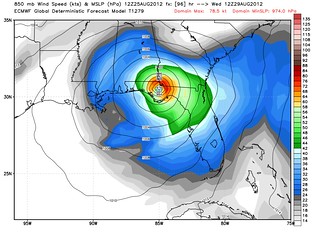
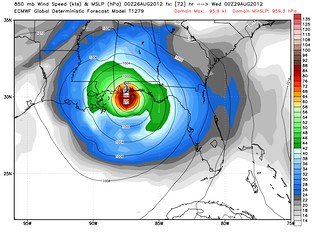
But because the GFS and the Euro — the two best-performing computer models — continue to disagree, with the GFS taking Isaac catastrophically into New Orleans while the Euro takes it to Mobile, substantial uncertainty will remain about Isaac’s track. Dr. Ryan Maue predicts the Euro’s projected landfall in Mobile “will prevent NHC from taking track any further west than that” until after another Euro run, which in turn means “it won’t be until [the] 5 pm advisory tomorrow before NHC expresses certainty on Landfall point — after ECMWF 12z at 2:15 PM.” In the mean time, New Orleans will almost certainly come to be in the “cone” by Sunday morning, but likely won’t be on the official track “line” until later, even if the GFS continues to predict a landfall there.
(To be clear: a disastrous strike on New Orleans is only one among many scenarios that could occur. Mobile, Pensacola, Panama City — you are all still in play. Heck, if the GFS’s westward drift continues, it’s conceivable that points in central or western Louisiana could end up being in play too. My focus on New Orleans doesn’t imply that New Orleans is the likeliest landfall spot, but only that it’d be the most catastrophic by far, and thus warrants a great deal of attention.)
Major uncertainty also remains about Isaac’s intensity. While the computer models insist on this storm blowing up into a major hurricane, Isaac is thus far being uncooperative. Observations from a recon plane indicate the storm has yet to begin strengthening since popping off the Cuban coast. Will it start soon, as expected? Perhaps, but Isaac has consistently failed to live up to the models’ expectations thus far, in terms of intensity. Maybe that will continue. We can hope.
Sunday will be a huge day in Isaac’s history, both in terms of “facts on the ground” (or in the atmosphere, I suppose) with respect to its real-time development, and in terms of the forecast models. I’ll be watching closely, tweeting, and blogging a few times during the day, as often as I can. That said, you can also view some of the raw data yourself. Here’s a timeline of events to watch (all times Eastern). I’ve put double asterisks (**) next to the particularly important events. The model links will be broken until the event occurs, or begins to occur.
5:00 AM: Full NHC advisory, discussion & forecast**
6:00 AM: GFS 06z run**
7:30 AM: HWRF 06z run
7:45 AM: GFDL 06z run
8:00 AM: Intermediate NHC advisory
11:00 AM: Full NHC advisory, discussion & forecast**
12:00 noon: GFS 12z run**
1:30 PM: HWRF 12z run
1:45 PM: GFDL 12z run
2:00 PM: Intermediate NHC advisory
2:10 PM: ECMWF (Euro) 12z run**
5:00 PM: Full NHC advisory, discussion & forecast**
6:00 PM: GFS 18z run**
7:30 PM: HWRF 18z run
7:45 PM: GFDL 18z run
8:00 PM: Intermediate NHC advisory
11:00 PM: Full NHC advisory, discussion & forecast**
12:00 midnight (Monday): GFS 00z run**
1:30 AM: HWRF 00z run
1:45 AM: GFDL 00z run
2:00 AM: Intermediate NHC advisory
2:10 AM: ECMWF (Euro) 00z run**
Other links to watch:
Wide View Water Vapor Loop (helpful for viewing steering currents)


Join the conversation as a VIP Member