
First things first. Today will be an important day in Isaac’s forecast history, as the computer models hopefully coalesce around a consensus track. This weekend will be even more important. I’ll update this blog as often as I can, but for the very latest updates, follow me on Twitter — @brendanloy.
Isaac’s wind speed is up to 60 mph as of 11:00 AM EDT, and its inner core is finally getting a bit better organized — though the window for further organization will end soon, as it reaches Haiti, and won’t really begin again until it pops off Cuba on Sunday. From the NHC’s discussion:
RECONNAISSANCE AIRCRAFT DATA AND SATELLITE IMAGERY INDICATE THAT ISAAC HAS BECOME BETTER ORGANIZED DURING THE PAST SEVERAL HOURS. WHILE THE CIRCULATION CENTER REMAINS ELONGATED EAST-TO-WEST WITH MULTIPLE EMBEDDED VORTICITY MAXIMA…THE LARGE CENTRAL AREA OF LIGHT WINDS HAS SHRUNK AS THE STRONGEST WINDS MOVE CLOSER TO THE CENTER. …
WHILE THE ORGANIZATION HAS IMPROVED…THE STRUCTURE OF ISAAC STILL DOES NOT FAVOR RAPID INTENSIFICATION DESPITE A VERY FAVORABLE UPPER-LEVEL WIND PATTERN. THE EARLY PART OF THE INTENSITY FORECAST SHOWS A LITTLE MORE STRENGTHENING THAN EARLIER…AND IT IS POSSIBLE THAT ISAAC COULD BE NEAR HURRICANE STRENGTH WHEN IT REACHES HISPANIOLA. LAND INTERACTION WILL LIMIT THE INTENSITY FROM 24-48 HR…AND THIS PART OF THE FORECAST MAY NEED SOME ADJUSTMENT AFTER IT IS SEEN WHAT STRUCTURE ISAAC HAS AFTER CROSSING HISPANIOLA. ISAAC SHOULD STRENGTHEN OVER THE GULF OF MEXICO…WITH THE FORECAST SHOWING THE CYCLONE BECOMING A HURRICANE BEFORE REACHING THE NORTHERN GULF COAST.
At present, the forecast is for “just” a Category 1 hurricane to hit the northeast Gulf Coast on Tuesday night or Wednesday morning. The NHC believes the roughly 24-30 hours Isaac will have over the Gulf before landfall won’t be enough time to become a major hurricane. They’re probably right, but it’s important to remember that hurricane intensity forecasting is an inexact science, especially in the 4-5 day range. Dr. Jeff Masters thinks a major hurricane Isaac is still not out of the question: “It is possible that Isaac could be approaching Category 3 strength by the time it makes landfall on Tuesday on the Gulf Coast, as suggested by the latest 06Z run of the HWRF model.”
Meanwhile, as I mentioned in a brief post earlier, the computer models’ westward shift yesterday — which had caused some folks, myself included, to fear that the “trend” might result in a New Orleans landfall consensus by today — has instead reversed itself, edging slightly back east. More importantly, the confidence of the forecast has increased somewhat, as the computer models are coming into better agreement. New Orleans is still technically within the NHC’s cone of uncertainty, but no trusted computer model is calling for a landfall west of Mobile, AL:
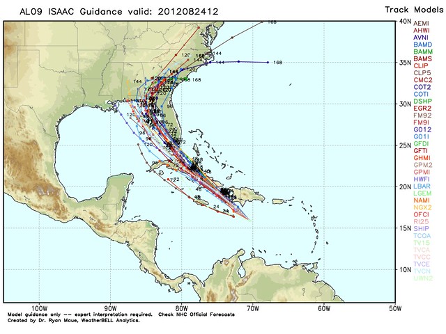
This is good news for New Orleans, which is still America’s most vulnerable city to flooding from a major hurricane, and also good news in general because it means Isaac will have less time over water to restrengthen after exiting Cuba. It’s not such good news, of course, for anyone between Mobile and Tallahassee, which now appears to be the most likely landfall zone. (The Panama City area is where the current official forecast track takes Isaac, though as the NHC reminds us: “IT IS IMPORTANT NOT TO FOCUS ON THE EXACT TRACK DUE TO THE UNCERTAINTIES IN THE FORECAST AND THE FACT THAT ISAAC HAS A LARGE AREA OF TROPICAL STORM FORCE WINDS ASSOCIATED WITH IT.”)
What about Tampa and the Republican National Convention? There, the answer remains a little more complicated. None of the trusted computer models take Isaac into or immediately near Tampa Bay, but several models’ forecast tracks have the storm fairly close to Florida’s West Coast, moving north or north-northwest, which almost parallels the coast. That’s still a plausible scenario, albeit not the NHC’s official forecast track.
Dr. Masters says he would “put the odds of a mass evacuation being ordered for Tampa during the convention at 1%,” in large part because “Isaac is going to be hard-pressed to bring hurricane-force winds to the city…since any path that takes it close to Tampa would keep the storm too close to land for significant intensification to occur.” Dr. Masters — an actual meteorologist, the founder of Weather Underground (the weather site, not the terrorist group), and a top-notch weatherblogger — is infinitely more qualified than me, and I trust his judgment. But, given the inherent uncertainty of intensity forecasting, and Isaac’s possible angle of approach, I’d still be a little nervous if I were Tampa Mayor Bob Buckworth or the Republican National Committee.
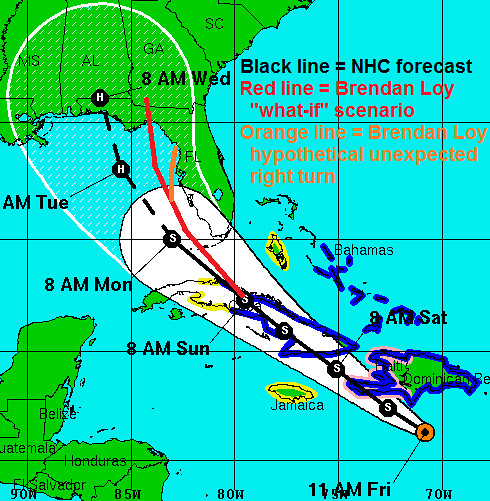
If you imagine Isaac’s path being shifted just a smidge to the right of what the NHC is currently forecasting, you can foresee a scenario where a high-end tropical storm or low-end Category 1 hurricane proceeds along a path Monday that is expected to keep it just offshore of Tampa, bringing only heavy rain, tropical storm-force wind gusts, and minimal storm surge to the city and the RNC. This would be more of a problem for “occupiers” than for convention delegates and city residents. But what if Isaac, after proceeding obediently along such a track (the red line below) for a while, makes an unexpected, last-minute right turn (the orange line) — something that’s been known to happen with Gulf hurricanes? And what if, just before that turn or around the same time, Isaac finally “gets its act together” and begins rapidly deepening — also something that’s been known to happen with Gulf hurricanes, and something that’s very difficult to predict? Tampa could go from a scenario where it looks to have “dodged a bullet,” to one where Isaac’s “right-front quadrant” is headed directly toward its storm surge-vulnerable bay, in a very short time.
Here’s a graphical representation of what I mean. To emphasize, I AM NOT A METEOROLOGIST, AND THIS IS NOT A FORECAST. I’m just pondering the scenario that would keep me up at night if I were Tampa Mayor Bob Buckhorn:
Buckhorn, though, sounds pretty confident:
As thousands of delegates, politicos and journalists prepared to travel to Tampa for the Republican National Convention, Tampa Mayor Bob Buckhorn on Friday downplayed the threat that Tropical Storm Isaac could pose to the event.
“We think the only impact will be some rain, some wind, no tidal surge, if you will,” Buckhorn said on CNN’s “Starting Point.” “So I think we are now more focused on full-steam ahead with the Republican National Convention, all of the preparations, getting ready for all the visitors and guests and members of the media that will be here.”
He’s probably right. But if it were me, I might wait for a few more computer model cycles before sounding the all-clear. Tampa would surely like to see the computer model consensus shift a little to the left again (though Pensacola, Mobile and points west would disagree).
The next set of computer models will be out in the next few hours, so we’ll see how the consensus evolves. Like I said, follow me on Twitter — @brendanloy — for the very latest.


Join the conversation as a VIP Member