
[NOTE: For my latest updates on Hurricane Sandy, follow me on Twitter.]
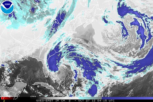
“It’s one of the ugliest looking hurricanes you’ll see,” writes Weather Channel Hurricane Specialist Bryan Norcross, “but Hurricane Hunters and satellite measurements confirm that it’s still tropical enough to be a hurricane… and it’s on track to cause a pile of trouble.”
Sandy is indeed still a hurricane, officially at least, as of 11:00 PM EST Friday. It’s “showing characteristics of a hybrid cyclone,” according to the NHC, and it will probably be temporarily downgraded sometime Saturday to a high-end tropical storm, as upper-level wind shear of 55-60 mph (!!) takes its toll. Again, though, this is not a sign of overhype, nor of Sandy underperforming its forecasts (as Isaac and Irene did). The computer models predicted this bout of weakening. They also predict that Sandy will eventually buck the shear, will move out over the unusually warm Gulf Stream waters, and will begin strengthening again, probably sometime Sunday.
Those models, by the way, also continue to spit out to predict scary forecasts like this and this. So this is no time to get complacent, folks. In fact, if you live in the potentially affected areas, Saturday is your day to really prepare, whatever that means in your specific circumstance. (Preparedness links can be found at the bottom of this post.) By Sunday, things will be getting frantic. BEAT THE RUSH, PREPARE NOW.
Anyway, back to the storm’s ragged appearance, which belies its deadly potential. Norcross explains what’s going on:
Two atmospheric processes are counteracting each other at the moment. Strong upper winds are trying to tear the storm apart, but a split in the upper flow is causing, essentially, a strong suction from above which is helping the storm keep going. This situation will likely result in some weakening… which would mean Sandy would drop below hurricane strength. But then the polar jet stream takes over and re-energizes the storm increasing the winds and growing the size. A sharp dip in the jet stream will pick up the reinvigorated Sandy and swing it toward the East Coast. At least that’s the plan.
There are some ifs and maybes in that scenario, but the best computer forecast models independently insist that this is what’s going to happen… and the not-so-reliable ones say the same thing.
As he put it in a tweet, “Either every model is wrong or this is serious as a heart attack.”
More, from the NHC’s 11pm discussion:
SANDY IS CURRENTLY EXPERIENCING ABOUT 50 KT OF VERTICAL WIND SHEAR WHICH IS DISRUPTING THE CONVECTIVE STRUCTURE. HOWEVER…VERY STRONG UPPER-LEVEL DIVERGENCE ASSOCIATED WITH A TROUGH SOUTHWEST OF THE HURRICANE IS LIKELY SUSTAINING THE CYCLONE. WHILE THESE CONDITIONS ARE FORECAST TO CONTINUE…IT IS LIKELY THAT SANDY WILL CONTINUE TO SLOWLY WEAKEN THROUGH 36 HR. SUBSEQUENTLY…THE DYNAMICAL MODELS FORECAST THAT INTERACTION WITH THE U. S. SHORTWAVE TROUGH WILL CAUSE SANDY TO RE-INTENSIFY PRIMARILY DUE TO BAROCLINIC ENERGY PROCESSES. THE INTENSITY FORECAST SHOWS SANDY REGAINING HURRICANE STRENGTH IN 48-72 HR. HOWEVER…THE CYCLONE WILL BE UNDERGOING EXTRATROPICAL TRANSITION AS THIS HAPPENS…AND WHEN THIS PROCESS WILL BE COMPLETE IS UNCERTAIN. REGARDLESS OF THE EXACT STRUCTURE AT LANDFALL…SANDY IS EXPECTED TO BE A LARGE AND POWERFUL CYCLONE WITH SIGNIFICANT IMPACTS EXTENDING WELL AWAY FROM THE LOCATION OF THE CENTER.
Again: we still aren’t sure exactly where Sandy will go, and a large section of the coastline will be affected regardless. Having said that, Norcross has some additional detail on the potential impact on one uniquely vulnerable city:
The ocean will rise along the coast as Sandy makes its way north, but the biggest coastal problems will come when the center makes landfall. We’re unlikely to know exactly where that will be until Monday, but this is critical. The ocean will be pushed toward the coast north of that point and away to the south. The onshore flow of water is exaggerated where bays, inlets, or the shape of the coastline focus the water to make it rise even higher. The most prominent problem spot is New York City, where Long Island and New Jersey make an “L”.
Raritan Bay and New York Bay and the south end of Manhattan are especially susceptible to rising water if the center of Sandy comes ashore in New Jersey or south. Much as we saw in Irene, it is potentially a monstrous problem due to the threat to NYC infrastructure and transportation. There are tough decisions ahead for the Mayor and his people.
Right now, the odds favor that southern [i.e., NJ/NYC] track. The threat from this situation is serious as a heart attack for anybody near the rising water.
Then there’s the wind which is expected to be MUCH higher than Irene at the skyscraper level. The city will also have to be thinking about the threat to people in tall buildings.
Norcross has more to say about other regions, too. Read the whole thing.
As for New York, if you live in Zone A or B, I’d say it’s time to immediately prepare to Get the Hell Out in the event evacuation orders become necessary, as they well may. I’m not sure about Zone C. I haven’t been able to find out what surge level, in feet, each zone can withstand; they’re based instead on Saffir-Simpson categories, which is fairly useless with a unique storm like this. But we could be looking at a 6-10 foot storm surge in NYC, plus astronomical high tide — as opposed to the 3-5 foot surge in Irene — if Sandy slams New Jersey from the east. So, yeah… significant evacuations are going to be necessary, methinks, unless the forecast changes.
There’s a lot more to say, but I’ve gotta sleep, so I’ll leave it at that for now, and post more tomorrow. In the mean time, check this Twitter list for the latest information, including the new European model run when it comes out in the hour of 2-3am Eastern Time, and the new NHC advisory and forecast track at 5am Eastern.
P.S. Oh, I almost forgot… here’s the me on Omaha radio, on Smash Davis’s show this afternoon. And here I am on NYC radio, talking about possible election impacts.
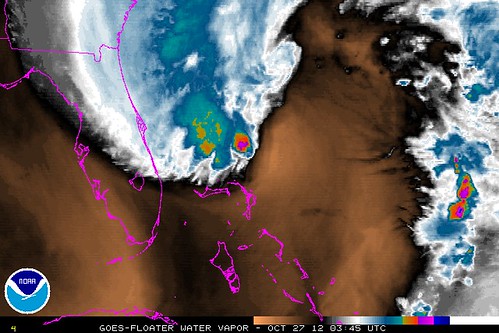
I’ve leave you with a water-vapor satellite image of the storm:
Good night. Sleep tight. Don’t let the tropopause folds bite.


Join the conversation as a VIP Member